
Harrows II
|
Eggen II ( isolated settlement ) village |
|||
|---|---|---|---|
|
|||
| Basic data | |||
| Pole. District , state | Sankt Veit an der Glan (SV), Carinthia | ||
| Judicial district | Sankt Veit an der Glan | ||
| Pole. local community | Liebenfels ( KG Freundsam ) | ||
| Coordinates | 46 ° 46 '16 " N , 14 ° 12' 56" E | ||
| height | 1000 m above sea level A. | ||
| Residents of the village | 4 (January 1, 2020) | ||
| Building status | 1 (January 1, 2011 ) | ||
| Statistical identification | |||
| Locality code | 01679 | ||

|
|||
| Source: STAT : index of places ; BEV : GEONAM ; KAGIS | |||

Eggen II is a village in the municipality of Liebenfels in the Sankt Veit an der Glan district in Carinthia . The village has 4 inhabitants (as of January 1, 2020). It lies entirely in the territory of the cadastral parish Freundsam .
location
The village is located in the southwest of the Sankt Veit an der Glan district, on a southern slope north of the Freundsamer Moos , just a few hundred meters east of the border with the Feldkirchen district .
history
The place was referred to in the Franziszeischen cadastre as Eggen bey Gradenegg . Located in the tax community of Freundsam, it was part of the tax district of Gradenegg and when the local communities were founded after the revolution of 1848/49, it came first to the community of Glantschach and in 1875 to the community of Sörg .
In the 19th century, it still consisted of three courtyards and was known as Rotte , but now there is only one courtyard.
When in 1973 the municipality of Sörg was connected to the municipality of Liebenfels, in whose area there was already another village called Eggen, there would have been two villages with the same name in one municipality. Therefore, since then the name forms Eggen II have been used for the place described here, formerly belonging to the municipality of Sörg, and Eggen I for a place 2 km south, formerly belonging to the municipality of Liemberg.
Population development
The following population figures were counted for the village:
- 1869: 3 houses, 21 inhabitants
- 1880: 5 houses, 21 inhabitants
- 1890: 3 houses, 32 inhabitants
- 1900: 3 houses, 30 inhabitants
- 1910: 3 houses, 17 inhabitants
- 1923: 3 houses, 14 inhabitants
- 1934: 17 inhabitants
- 1961: 1 house, 5 inhabitants
- 2001: 1 building (including 1 with main residence) with 1 apartment and 1 household; 6 residents and 1 secondary residence case
- 2011: 1 building, 5 residents
There are 0 workplaces in the village (status 2011; 2001: 0) and 0 agricultural and forestry operations (status 2001).

South-eastern entrance to Eggen II, house number 2 in the background

Eggen II, house no.1a
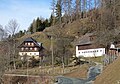
Eggen II, house no.1a and 1


Individual evidence
- ↑ Statistics Austria: Population on January 1st, 2020 by locality (area status on January 1st, 2020) , ( CSV )
- ↑ a b K. K. Central Statistical Commission (ed.): Complete list of localities of the kingdoms and countries represented in the Reichsrathe according to the results of the census of December 31, 1880. Alfred Hölder, Vienna 1882. S. 60.
- ^ Central Statistical Commission: Local Repertory of the Duchy of Carinthia. Based on the census of December 31, 1869. Carl Gerold's Sohn, Vienna 1872. P. 72.
- ↑ KK Statistische Central-Commission (Hrsg.): Local repertories of the kingdoms and countries represented in the Austrian Reichsrathe. Revised based on the results of the census of December 31, 1890. V. Carinthia. Alfred Hölder, Vienna 1894. p. 61.
- ↑ KK Central Statistical Commission (ed.): Community encyclopedia of the kingdoms and countries represented in the Reichsrat. Revised based on the results of the census of December 31, 1900. V. Carinthia. KK Hof- und Staatsdruckerei, Vienna 1905. p. 82.
- ^ Central Statistical Commission (ed.): Special locations repertory of the Austrian countries. Edited on the basis of the results of the census of December 31, 1910. V. Carinthia. Verlag der Staatsdruckerei, Vienna 1918. p. 43.
- ^ Federal Statistical Office (ed.): Directory of Austria. Edited on the basis of the results of the census of March 7, 1923. Österreichische Staatsdruckerei, Vienna 1930. Section Carinthia, p. 18.
- ↑ Handwritten addendum to the 1923 local directory (Federal Statistical Office (Hrsg.): Local directory of Austria. Edited on the basis of the results of the census of March 7, 1923. Österreichische Staatsdruckerei, Vienna 1930.) with the signature II 28238 of the Klagenfurt University Library. Section Carinthia, p. 18.
- ^ Austrian Central Statistical Office: Directory of Austria. Edited on the basis of the results of the census of March 21, 1961. Österreichische Staatsdruckerei, 1965. p. 257.
- ↑ a b c Statistics Austria (Ed.): Local directory 2001 Carinthia. Vienna 2004. 111.
- ^ A b Office of the Carinthian regional government, regional statistical office: Carinthian local directory. Territorial status January 1, 2014. Klagenfurt, 2014.

Cadastral communities: friendly | Glantschach | Gradenegg | Hardegg | Liebenfels | Liemberg | Pflausach | Rosenbichl | Rottschaft Feistritz | Sörg | Soergerberg
Locations: Bärndorf | Beißendorf | Harrows I | Harrows II | Friendly | Gasmai | Glantschach | Gßeberg | Dig | Gradenegg | Grassendorf | Reason | Hardegg | Hard | Hoch-Liebenfels | Hohenstein | Kraindorf | Kulm | Ladein | Lebmach | Liebenfels | Liemberg | Lorberhof | Mailsberg | Metschach | Miedling | Moss | Pflausach | Plowing | Pulse | Puppitsch | Radelsdorf | Rasting | Reidenau | Rohnsdorf | Rosenbichl | Sörg | Sörgerberg | St. Leonhard | Chadam | Waggendorf | Wasai | Weitensfeld | Woitsch | Zmuln | Zojach | Zwattendorf | Two churches
(Former) parts of the village: Grientschach | Undergrowth | Schoberhof | Seidelhof | Divorce
Counting district: Liebenfels-Nord | Liebenfels-Süd | Sörg
Former communities: Community of Glantschach 1850–1875 | Hardegg municipality 1850–1958 | Liemberg municipality 1850–1958 | Municipality of Pulst 1850–1958 (of which 1850–1875 as municipality of Feistritz ) | Municipality of Sörg 1875–1973