
Gradenegg (municipality of Liebenfels)
|
Gradenegg ( Rotte ) locality |
|||
|---|---|---|---|
|
|||
| Basic data | |||
| Pole. District , state | Sankt Veit an der Glan (SV), Carinthia | ||
| Judicial district | Sankt Veit an der Glan | ||
| Pole. local community | Liebenfels ( KG Gradenegg ) | ||
| Coordinates | 46 ° 45 ′ 19 ″ N , 14 ° 14 ′ 46 ″ E | ||
| height | 830 m above sea level A. | ||
| Residents of the village | 98 (January 1, 2020) | ||
| Building status | 44 (January 1, 2011 ) | ||
| Statistical identification | |||
| Locality code | 01683 | ||
 Gradenegg |
|||
| Source: STAT : index of places ; BEV : GEONAM ; KAGIS | |||

Gradenegg is a village in the municipality of Liebenfels in the Sankt Veit an der Glan district in Carinthia . The village has 98 inhabitants (as of January 1, 2020). It lies entirely in the territory of the cadastral community of Gradenegg . The name of the place is derived from the Slovene Gradnice (= Schlossbach village ).
location
The village is located in the southwest of the Sankt Veit an der Glan district, on a slope in the Wimitz Mountains that slopes down to the southwest .
history
The name Gradnich is mentioned in 1192. The Lords of Gradenegg sat at Gradenegg Castle , a little above today's town; the castle, which was inhabited until around 1800, is today considered to be part of the neighborhood Freundsam .
In the first half of the 19th century, the municipality belonging to the Gradenegg tax community was part of the Gradenegg tax district . When the local congregations were formed in the course of the reforms after the revolution in 1848/49, the village first came to the municipality of Glantschach , and in 1875 it was attached to the municipality of Sörg . Since the merger of the communities of Sörg and Liebenfels in 1973, the place has belonged to the community of Liebenfels.
Population development
The following population figures were counted for the village:
- 1869: 12 houses, 82 inhabitants (still without undergrowth)
- 1880: 15 houses, 75 inhabitants
- 1890: 13 houses, 97 inhabitants
- 1900: 15 houses, 87 inhabitants
- 1910: 22 houses, 143 inhabitants (now including undergrowth)
- 1923: 23 houses, 146 inhabitants
- 1934: 149 inhabitants
- 1961: 24 houses, 147 inhabitants
- 2001: 38 buildings (38 of them with main residence) with 39 apartments and 31 households; 94 residents and 9 cases of secondary residence
- 2011: 44 buildings, 108 inhabitants
There are 8 workplaces (as of 2011; 2001: 3) and 13 agricultural and forestry operations (as of 2001) in the village.
Part of the village undergrowth

As part of the locality of Gradenegg, the Rotte Unterholz was temporarily run, which is located in the north of the village, below the castle ruins. Initially, this settlement, although located in the area of the cadastral community of Gradenegg, was counted as part of the Freundsam community without any separate mention.In 1890 it was designated as a part of Freundsam, later as part of Gradenegg.
- 1890: 5 houses, 51 inhabitants (as part of the village of Freundsam)
- 1910: 5 houses, 48 inhabitants (as part of the village of Gradenegg)
- 1923: 5 houses, 31 inhabitants (as part of the village of Gradenegg)
- 1961: 6 houses, 41 inhabitants (as part of the village of Gradenegg)
The undergrowth belonging to Gradenegg is no longer specifically identified in the latest local registers.
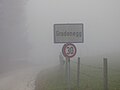
Gradenegg town sign
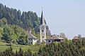
Gradenegg Church

Gradenegg rectory

Gradenegg House No. 4

former elementary school in Gradenegg


Individual evidence
- ↑ Statistics Austria: Population on January 1st, 2020 by locality (area status on January 1st, 2020) , ( CSV )
- ↑ a b Community Liebenfels (ed.): Community chronicle Liebenfels. 1998, p. 373.
- ^ Central Statistical Commission: Local Repertory of the Duchy of Carinthia. Based on the census of December 31, 1869. Carl Gerold's Sohn, Vienna 1872. P. 72.
- ^ KK Statistische Central-Commission (Ed.): Complete list of localities of the kingdoms and countries represented in the Reichsrathe according to the results of the census of December 31, 1880. Alfred Hölder, Vienna 1882. S. 60.
- ↑ a b K. K. Central Statistical Commission (Ed.): Local repertories of the kingdoms and countries represented in the Austrian Reichsrathe. Revised based on the results of the census of December 31, 1890. V. Carinthia. Alfred Hölder, Vienna 1894. p. 61.
- ↑ KK Central Statistical Commission (ed.): Community encyclopedia of the kingdoms and countries represented in the Reichsrat. Revised based on the results of the census of December 31, 1900. V. Carinthia. KK Hof- und Staatsdruckerei, Vienna 1905. p. 82.
- ↑ a b Statistical Central Commission (Ed.): Special locations repertory of the Austrian countries. Edited on the basis of the results of the census of December 31, 1910. V. Carinthia. Verlag der Staatsdruckerei, Vienna 1918. p. 43.
- ↑ a b Federal Statistical Office (ed.): Local directory of Austria. Edited on the basis of the results of the census of March 7, 1923. Österreichische Staatsdruckerei, Vienna 1930. Section Carinthia, p. 18.
- ↑ Handwritten addendum to the 1923 local directory (Federal Statistical Office (Hrsg.): Local directory of Austria. Edited on the basis of the results of the census of March 7, 1923. Österreichische Staatsdruckerei, Vienna 1930.) with the signature II 28238 of the Klagenfurt University Library. Section Carinthia, p. 18.
- ^ A b Austrian Central Statistical Office: Directory of Austria. Edited on the basis of the results of the census of March 21, 1961. Österreichische Staatsdruckerei, 1965. p. 257.
- ↑ a b c Statistics Austria (Ed.): Local directory 2001 Carinthia. Vienna 2004. 112.
- ^ A b Office of the Carinthian regional government, regional statistical office: Carinthian local directory. Territorial status January 1, 2014. Klagenfurt, 2014.

Cadastral communities: friendly | Glantschach | Gradenegg | Hardegg | Liebenfels | Liemberg | Pflausach | Rosenbichl | Rottschaft Feistritz | Sörg | Soergerberg
Locations: Bärndorf | Beißendorf | Harrows I | Harrows II | Friendly | Gasmai | Glantschach | Gßeberg | Dig | Gradenegg | Grassendorf | Reason | Hardegg | Hard | Hoch-Liebenfels | Hohenstein | Kraindorf | Kulm | Ladein | Lebmach | Liebenfels | Liemberg | Lorberhof | Mailsberg | Metschach | Miedling | Moss | Pflausach | Plowing | Pulse | Puppitsch | Radelsdorf | Rasting | Reidenau | Rohnsdorf | Rosenbichl | Sörg | Sörgerberg | St. Leonhard | Chadam | Waggendorf | Wasai | Weitensfeld | Woitsch | Zmuln | Zojach | Zwattendorf | Two churches
(Former) parts of the village: Grientschach | Undergrowth | Schoberhof | Seidelhof | Divorce
Counting district: Liebenfels-Nord | Liebenfels-Süd | Sörg
Former communities: Community of Glantschach 1850–1875 | Hardegg municipality 1850–1958 | Liemberg municipality 1850–1958 | Municipality of Pulst 1850–1958 (of which 1850–1875 as municipality of Feistritz ) | Municipality of Sörg 1875–1973