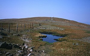
Hard fur (Mardale)
| Hard fur | ||
|---|---|---|
|
Look to the hard fur |
||
| height | 778 m | |
| location | Cumbria , England | |
| Mountains | Cumbrian Mountains | |
| Coordinates | 54 ° 28 '34 " N , 2 ° 50' 6" W | |
|
|
||
| Type | Wainwright | |
The Harter Fell is a 778 m high mountain in the east of the Lake District in England , Cumbria . The summit is located at the meeting point of three mountain ridges and the mountain is at the end of three valleys: Mardale , Longsleddale and Kentmere .
There is also a hard coat between the Eskdale Valley and the Duddon Valley in the west of the Lake District.
Topography
The summit plateau forms a horseshoe with an opening to the southeast. The plateau is narrow and overgrown with grass. There is a sub-peak at each end of the horseshoe.
The southern ridge leads over The Knowe and Brown Howe to Kentmere Pike . The eastern ridge leads over Little Harter Fell and Adam Seat down to Gatescarth Pass where it goes back up to the Branstree .
A third lower ridge leads into the middle of the horseshoe and descends to Nan Bield Pass and joins Mardale Ill Bell and High Street .
The River Sprint rises south below the Harter Fell and the Kentmere Reservoir lies on its western flank. In the north of the mountain is the Small Water Lake.
Ascent
The Nan Bield and Gatescarth mountain passes were a traditional trade route connecting the Mardale Valley with Kentmere and Longsleddale. With the construction of the Haweswater Reservoir , the original character of this connection ceased, but it now offers an easy way to the Harter Fell with a road connection to the end of the Haweswater Reservoir. You can also climb from Kentmere or Longsleddale via the passes.
On a hike over Kentmere Pike to Harter Fell, with a continuation of the path over Mardale Ill Bell, the so-called Kentmere Horseshoe is formed. A combination of Harter Fell with Branstree, Mardale Ill Bell and High Street leads in an arc up around the Mardale valley.
An ascent is also possible directly from Longsleddale Valley via the former Wrengill Quarry quarry.
The summit
The summit offers a good all-round view, including the entire Haweswater Reservoir. There are two cairns on the summit .
Classification
The Harter Fell is a Wainwright . It was originally listed as Marilyn , but new measurements have shown that it is only 149 m high and is one meter short of the categorization.
swell
- Alfred Wainwright, A Pictorial Guide to the Lakeland Fells, Book 2, The Far Eastern Fells. ISBN 0-7112-2455-2

