Hasselberg (Radewege)
| Hasselberg | ||
|---|---|---|
|
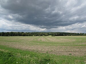
The Hasselberg from the southeast |
||
| height | 58.8 m | |
| location | Brandenburg , Germany | |
| Mountains | Nauen plate | |
| Coordinates | 52 ° 29 '12 " N , 12 ° 35' 29" E | |
|
|
||
| Type | Terminal moraine | |
The Hasselberg is a 58.8 meter high, Ice Age shaped elevation near the village of Radewege in the municipality of Beetzsee in the north of the Potsdam-Mittelmark district in Brandenburg . The municipal boundary to Beetzseeheide runs over the eastern slope . Several important prehistoric urn burial grounds were discovered on the Hasselberg.
morphology
The Hasselberg was formed during the last, the Vistula cold period . Ice masses penetrating from the northeast to Central Europe formed the ridge of the Nauener Platte . Part of this plateau is the Hasselberg, raised by the inland ice as a compression moraine complex. The Hasselberg was built on the edge of the ice sheet 2 of the Brandenburg phase with the line Schwarzer Berg - Hasselberg - Wasenberg - Weinberg - Götzer Berg .
Burial ground

The Hasselberg was used as a burial place in prehistoric times. One of the largest urn grave cemeteries in the Elbe-Havel area and the area around the city of Brandenburg was found on it . The finds could be dated from the late Roman Empire to the beginning of the Great Migration Period. Most of the time, bowl-shaped urns without any additions were found. A single find was, for example, a fibula that can be ascribed to the area around Niemberg and a belt buckle . The finds made were dated between the 3rd and 5th centuries. In addition to these urn graves, other graves from the Stone Age were secured on Hasselberg , which were assigned to the Havelländische culture . The sites are designated as a ground monument.
use
The Hasselberg was prehistorically used as a burial place. In modern times, its warm, dry locations were used for viticulture for a while. Since a reforestation, the Hasselberg has been covered with an extensive pine forest. Furthermore, like the nearby Beetzsee, it is used by the population for recreational purposes. There is a campsite between the lake shore and the mountain. The Radewege elementary school "Am Beetzsee" is located on the southern slope.
Protected areas
The hilly elevation of Hassel Berg is in the conservation area Westhavelland and Westhavelland Nature Park . It is also part of the Mittlere Havelniederung SPA area .
Individual evidence
- ↑ Sebastian children and Haik Thomas Porada (ed.): Brandenburg an der Havel and surroundings. 2006, pp. 5, 7, 138, ISBN 978-3-412-09103-3 .
- ↑ Sebastian children and Haik Thomas Porada (ed.): Brandenburg an der Havel and surroundings. 2006, p. 298, fig. 72, ISBN 978-3-412-09103-3 .
- ↑ Sebastian children and Haik Thomas Porada (ed.): Brandenburg an der Havel and surroundings. 2006, p. 140, ISBN 978-3-412-09103-3 .
- ↑ List of monuments of the state of Brandenburg; Potsdam-Mittelmark district; Ground memorials ( Memento of the original from January 6, 2016 in the Internet Archive ) Info: The archive link was inserted automatically and has not yet been checked. Please check the original and archive link according to the instructions and then remove this notice. . Accessed January 7, 2014
- ↑ Sebastian children and Haik Thomas Porada (ed.): Brandenburg an der Havel and surroundings. 2006, p. 25, fig. 9 (draft by H.-D. Krausch), ISBN 978-3-412-09103-3 .
- ↑ Beetzseeheide municipality; Butzow campsite . Accessed May 29, 2014.
- ^ Primary school "Am Beetzsee" in Radewege . Accessed May 29, 2014.
- ↑ Part sheet Northwest Protected Areas. (PDF) In: Landkreis Potsdam-Mittelmark landscape framework plan. Office for Environmental and Landscape Planning, archived from the original on August 7, 2011 ; Retrieved October 16, 2013 .

