Hatu-Builico
| Hatu-Builico | ||
|---|---|---|
|
|
||
| Coordinates | 8 ° 54 ′ S , 125 ° 31 ′ E | |

|
||
| Basic data | ||
| Country | East Timor | |
| Ainaro | ||
| Administrative office | Hatu-Builico | |
| ISO 3166-2 | TL-AN | |
| Suco | Nuno-Mogue | |
| height | 2155 m | |
|
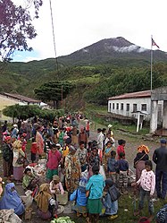
Market day in Hatu-Builico. In the background the Tatamailau .
|
||
Hatu-Builico ( Hatu Builico , Hato Builico , Hato-Builico , Hatobuilico , Hatubulica ) is an East Timorese place in the administrative office of Hatu-Builico ( municipality of Ainaro ).
1936 Hatu-Builico was by the Portuguese after the Lusitanian leader Viriathus in Viriato renamed. But the name did not catch on and a few years after the Second World War , the old name was reverted to. It means "loose stone" in the local language Mambai .
geography
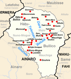
The place Hatu-Builico is in the northwest of the administrative office, in Suco Nuno-Mogue , near the Telemau river . At 2155 m above sea level, Hatu-Builico is the highest and therefore, on average, the coldest place in the country. From here, within two and a half hours, the easiest route leads to Tatamailau ( 2963 m ), East Timor's highest mountain. It is about 37 km to the north as the crow flies to the state capital Dili and about 12 km to the south to the municipal capital Ainaro . The administrative seat of the administrative office is east in Suco Mulo .
There is a primary school, a medical station and a permanent helipad in the village.
history
After crop failures in 2006, twelve percent of the population suffered from malnutrition. António Lopes , Chef de Suco at Nuno-Mogue, accused the FRETILIN government of ignoring appeals for aid.
Town twinning
Sons and daughters
- Sérgio Lobo (* 1958), East Timorese politician
Web links
- Hatu-Builico Walking guide 2011 (PDF, English)
Individual evidence
- ↑ Geoffrey Hull : The placenames of East Timor , in: Placenames Australia (ANPS): Newsletter of the Australian National Placenames Survey, June 2006, pp. 6 & 7, ( Memento of the original from February 14, 2017 in the Internet Archive ) Info: The archive link was inserted automatically and has not yet been checked. Please check the original and archive link according to the instructions and then remove this notice. accessed on September 28, 2014.
- ^ João Soares: Novo Atlas Escolar Português , 5th updated edition, Lisboa 1954
- ↑ Visit East Timor: Mount Ramelau (Foho Tatamailau) , accessed June 9, 2019.
- ↑ UNMIT: Timor-Leste District Atlas version 02, August 2008 ( Memento of the original from December 3, 2011 in the Internet Archive ) Info: The archive link has been inserted automatically and has not yet been checked. Please check the original and archive link according to the instructions and then remove this notice. (PDF; 583 kB)
- ^ Blue Mountains City Council: East Timor Friendship Committee
- ^ Blue Mountains East Timor Sisters

