Haumesserbach
| Haumesserbach | ||
|
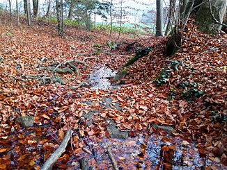
The Haumesserbach at the target range of the Maur shooting range |
||
| Data | ||
| Water code | CH : ZH101643 | |
| location |
Switzerland
|
|
| River system | Rhine | |
| Drain over | Dorfbach → Glatt → Rhine → North Sea | |
| source | in the corridor Töbeli am Wassberg near Aesch 47 ° 20 ′ 7 ″ N , 8 ° 38 ′ 55 ″ E |
|
| Source height | approx. 717 m above sea level M. | |
| muzzle | at the settlement boundary of Maur in the Dorfbach Coordinates: 47 ° 20 ′ 15 ″ N , 8 ° 40 ′ 4 ″ E ; CH1903: 692.89 thousand / 243681 47 ° 20 '15 " N , 8 ° 40' 4" O |
|
| Mouth height | approx. 472 m above sea level M. | |
| Height difference | approx. 245 m | |
| Bottom slope | approx. 14% | |
| length | 1.7 km | |
| Communities | Maur | |
|
The Haumesserbach at the disc stand with a view down the stream |
||
The Haumesserbach is a 1.7 km long left tributary of the Dorfbach in the Swiss municipality of Maur , Canton of Zurich . The stream drains a section of the Pfannenstiel ridge in the Zurich Oberland .
course
The Haumesserbach rises at about 717 m above sea level. M. in a wood on the eastern slope of the Wassberg just north of the Forch . After a short course through a small ravine (Töbeli) he is at the tree line in the Schürwiis culverts first time. He crosses under this and the Schleipfenacher , between Aesch and Looren the Aescherstrasse , the Roggacher and the Hasenacher . The stream now reaches the Haumesser hallway that gives it its name , where it comes to the surface again in a small wood. It flows through the forest above the Maur Schützenhaus and passes the target position . At the tree line it is overturned again and passes under the mountain meadows . It reappears at the settlement boundary of Maur, and forms this at the same time. He is accompanied by thick bushes before he reaches about 472 m above sea level. M. flows from the left into the lower course of the Dorfbach, whose largest tributary it represents.
Web links
- Course of the Haumesserbach on GIS Zurich
- Course of the Haumesserbach on the geoserver of the Swiss federal administration

