Haverhill (Suffolk)
| Haverhill | ||
|---|---|---|
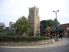
| Market Hill and Church | ||
| Coordinates | 52 ° 5 ' N , 0 ° 26' E | |
| OS National Grid | TL671456 | |
|
|
||
| Residents | 22,010 (as of 2001) | |
| administration | ||
| Post town | HAVERHILL | |
| prefix | 01440 | |
| Part of the country | England | |
| Shire county | Suffolk | |
| District | West Suffolk | |
| British Parliament | West Suffolk | |
| Website: www.haverhill-uk.com | ||
Haverhill is a civil parish in the district of Suffolk , England on the borders of Essex and Cambridgeshire , is 23 km south-east of Cambridge and 80 km north of London and is the second largest city in the West Suffolk district with 22,010 inhabitants .
geography
The town center lies at the foot of a gentle cut in the chalk cliffs of Newmarket Ridge. Through the city flows Stour Brook , in the River Stour flows just outside the town. Due to the rapid expansion of the city over the past two decades, the hamlet of Hanchet Enddie is now on the western edge of Haverhill. The surrounding landscape consists mainly of arable land.
history
Haverhill is already mentioned in the Domesday Book (1086). Most of the historic buildings were lost in the "Great Fire" on June 14, 1667.
The expansion following a planning decision in 1956 changed many aspects of life in Haverhill. The local Suffolk accent has been largely replaced by a London-South-East England accent. Today Haverhill is mostly a modern and young city. The relatively small town center is surrounded by many large residential areas that were built between 1950 and today.
economy
Haverhill's economy is dominated by industry, which is predominantly found in a large industrial area in the southeast of the city.
After the bypass was built, another business park was created, bringing new businesses to Haverhill. The center of the city has been revitalized in the evening with the construction of a Cineworld cinema. In autumn 2009, Tesco opened a new supermarket right in the city center on the site of the old train station.
The weekly high street market every Saturday is a long tradition in Haverhill.
traffic
The A1307 road is the only major road linking Haverhill to Braintree, Cambridge and the M11 motorway. Haverhill bus station also has connections to some of the surrounding villages and hamlets.
Haverhill is one of the largest cities in England without its own train station. The nearest train station is Audley End . Connections between Cambridge and London can be reached here. The nearest airport for domestic and international flights is London Stansted Airport (around 30 km south). The much smaller Cambridge City Airport also serves some domestic flights.
Culture
2000/2001, 2,000 Haverhill residents were photographed by artist Chris Dorley-Brown and transformed into a single image that was exhibited in the National Portrait Gallery in London as the largest photographic morphing project of its kind.
As of November 2004, Haverhill has been the only city to have a laser-illuminated sculpture in a roundabout at night. The 11 meter high steel sculpture “Spirit of Enterprise” (called “The bin” or “The toilet roll” by the locals) was primarily financed by local companies.
Partnerships
Haverhill is partnered with
-
 Ehringshausen , Germany since April 16, 1983
 -
 Pont-Saint-Esprit , France
The city of Haverhill in Massachusetts , USA is named after Haverhill.


