
Haveri
| Haveri ಹಾವೇರಿ |
|||
|---|---|---|---|
|
|||
| State : |
|
||
| State : | Karnataka | ||
| District : | Haveri | ||
| Sub-district : | Haveri | ||
| Location : | 14 ° 48 ' N , 75 ° 24' E | ||
| Height : | 580 m | ||
| Area : | 4.823 km² | ||
| Residents : | 67,102 (2011) | ||
| Population density : | 13,913 inhabitants / km² | ||
 |
|||

Haveri ( Kannada : ಹಾವೇರಿ ) is a city in the Indian state of Karnataka with around 70,000 inhabitants. It is the administrative seat of the district of the same name .
location
Haveri is located in north-central Karnataka about 325 km (driving distance) northwest of Bangalore and 80 km south of Hubli-Dharwad at an altitude of about 580 m above sea level. d. M. on the Dekkan Plateau.
population
Official population statistics have only been kept and published since 1991. The urban population growth is mainly based on immigration from rural regions.
| year | 1991 | 2001 | 2011 |
| Residents | 45,295 | 55,913 | 67.102 |
Approx. 70% of the majority Kannada- speaking population are Hindus and about 27% are Muslims ; other religions ( Jains , Sikhs , Buddhists , Christians etc.) form numerically small minorities. The male population is only slightly higher than the female.
economy
The surrounding area is still oriented towards agriculture, whereby the self-sufficiency economy that had existed for centuries was more and more replaced by market economy elements with the emergence of better transport conditions in the second half of the 20th century. In the city itself, regional handicrafts, retail trade and services of all kinds (health, education, transport, etc.)
history
In the Middle Ages, the place and temple belonged to the sphere of influence of the western Chalukya dynasty; In the 14th century, the Vijayanagar empire took power, which was defeated by the united Dekkan sultanates in the battle of Talikota (1565). The British also controlled southern India from the 18th century .
Attractions
- The main attraction of the city is the Siddheshwara Temple from the Chalukya period in the early 12th century. Exceptionally it faces east, i.e. H. facing towards the rising sun and already shows all the elements that are also used in the mostly later Hoysala temples : a richly structured cella ( garbhagriha ) with a tower structure ( vimana ), a small anteroom ( antarala or sukhanasi ) and a small transverse one Vestibule ( mandapa ) and - probably later - a large vestibule, almost star-shaped in plan, with wide balcony openings. The outer walls of the cella are richly decorated with figures and tower-like reliefs; the wide-open vestibule shows little decoration apart from the turned and carved soapstone columns and the richly decorated ceiling compartments inside. The actual cella is separated from the anteroom by a stone grille ( jali ).
- Next to the temple is an unwritten late medieval hero Tele ( hero stone ) with Shiva lingam (above), sitting Jain - Tirthankara (middle) and a war scene (below).

Exterior wall detail with kirtimukha

Lion monster ( kirtimukha )
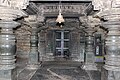
Vestibule ( mandapa )

Hero Tele ( hero stone )


- Surroundings
- Approx. The place Galaganatha with the regionally important medieval Galageshwar temple is located 52 km northeast .
Web links
- Haveri, Temple - Photo + Info (English)