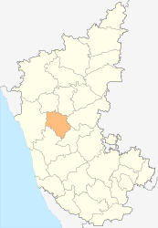
Haveri (district)
| Haveri District ಹಾವೇರಿ ಜಿಲ್ಲೆ |
|
|---|---|

|
|
| State | Karnataka |
| Division : | Belgaum |
| Administrative headquarters : | Haveri |
| Area : | 4,829 km² |
| Residents : | 1,598,506 (2011) |
| Population density : | 331 inhabitants / km² |
| Website : | haveri.nic.in |
The Haveri District ( Kannada : ಹಾವೇರಿ ಜಿಲ್ಲೆ ) is a district of the Indian state of Karnataka . The administrative seat is the eponymous city Haveri .
geography
The Haveri district is located in north-central Karnataka. Neighboring districts are Dharwad in the north, Gadag in the northeast, Bellary in the east, Davanagere in the southeast, Shimoga in the southwest and Uttara Kannada in the west.
The area of the district is 4,829 square kilometers. The district area belongs to the highlands of Dekkan and has an average height of 500 to 600 meters above sea level. The Varada , a tributary of the Tungabhadra, flows through the district . The Tungabhadra itself forms the border with the Davanagere district in the southeast.
The Haveri district is divided into the seven taluks Shiggaon, Savanur, Hangal, Haveri, Byadgi, Hirekerur and Ranibennur.
history
The Haveri district has existed as an independent district since 1997. The area had previously been part of the Dharwad district.
population
According to the 2001 census, Haveri district has 1,598,506 inhabitants. Between 2001 and 2011, the population grew by 11.1 percent and thus a little more slowly than the average in Karnataka (15.7 percent). The population density of 331 people per square kilometer is close to the state average (319 people per square kilometer). 22.3 percent of the population of Haveri district live in cities. The degree of urbanization is thus lower than the mean value in Karnataka (38.6 percent). At 77.6 percent, the literacy rate is in line with the state average (75.6 percent).
According to the 2001 census , Hindus make up the majority of the inhabitants of the Haveri district with 80.8 percent. There is also a larger Muslim minority of 17.6 percent. The census classifies 8.8 percent of the population as members of the tribal population (cf. Adivasi ). These are almost exclusively members of the Naikda . In addition to Kannada , the main language of Karnataka, Urdu is common among the Muslim population of the Haveri district, as in most parts of Karnataka . In the Hangal, Savanur and Shiggaon talks of Haveri District, Urdu has the status of an associated official language due to the high proportion of its speakers in the population.
Cities
| city | Population (2001) |
|---|---|
| Bankapura | 20,264 |
| Byadgi | 25,658 |
| Hangal | 25,011 |
| Haveri | 55,900 |
| Hirekerur | 15,874 |
| Kodiyal | 6,726 |
| Ranibe only | 89,594 |
| Savanur | 35,561 |
| Shiggaon | 24,318 |
Web links
Individual evidence
- ↑ Census of India 2011: Provisional Population Totals: Data Sheet (PDF; 1.7 MB) and Population and decadal growth rate by residence Persons. (PDF; 1.3 MB)
- ^ Census of India 2001: Basic Data Sheet. District Haveri (11), Karnataka (29). (PDF; 55 kB)
- ↑ AR Fatihi: "Urdu in Karnataka", in: Language in India 2: 9 December of 2002.
- ↑ Census of India 2001: Population, population in the age group 0-6 and literates by sex - Cities / Towns (in alphabetic order) ( Memento from June 16, 2004 in the Internet Archive )