
Hangal
| Hangal ಹಾನಗಲ್ |
|||
|---|---|---|---|
|
|||
| State : |
|
||
| State : | Karnataka | ||
| District : | Haveri | ||
| Location : | 14 ° 46 ′ N , 75 ° 8 ′ E | ||
| Height : | 560 m | ||
| Area : | 24.4 km² | ||
| Residents : | 28,159 (2011) | ||
| Population density : | 1154 inhabitants / km² | ||
 |
|||

Hangal or Hanagalla ( Kannada : ಹಾನಗಲ್ ) is a historically significant city with around 30,000 inhabitants in the Indian state of Karnataka .
Location and climate
Hangal is located in the northwest of Karnataka on the Dekkan Plateau at an altitude of about 560 m, about 37 km (driving distance) west of the district capital Haveri . The climate is subtropical and warm; Rain (approx. 780 mm / year) almost only falls in the summer monsoon months .
population
Official population statistics have only been kept and published since 1991.
| year | 1991 | 2001 | 2011 |
| Residents | 20,906 | 25.009 | 28,159 |
A good 51% of the majority of the Kannada- speaking population are Hindus , around 48% are Muslims and less than 1% belong to other religious groups such as Jains , Sikhs , Buddhists and Christians . The male part of the population exceeds the female population by approximately 4%.
economy
The area around Hangal is largely agriculturally oriented; Craftsmen, traders and service providers of all kinds have settled in the city itself.
history

The area around Hangal (formerly Panungal , later Viratakote or Viratanagari ) belonged to the kingdom of the Kadamba , the Chalukyas of Badami and the Rashtrakutas in the early Middle Ages . As inscriptions testify, the city came under the sphere of influence of the Chalukyas of Kalyani in the 11th and 12th centuries until the Kalachuri and the Hoysala gradually took power, which was followed in 1348 by the Vijayanagar Empire, which itself in 1565 in battle von Talikota was subject to the combined armies of the Deccan sultanates . However, these were divided among themselves and so the Hindu princely state of Mysore was able to take over power for a time, which was contested by the sultans of the Adil Shahi dynasty of Bijapur . From 1761 to 1799 Haidar Ali and Tipu Sultan , two more or less independently ruling generals of the princely state of Mysore, occupied power; thereafter the British extended their influence to southern India.
Attractions

- The richly structured ( rathas ) Tarakeshwara temple, consecrated to the Hindu god Shiva , dates from the Chalukya period (12th century). It consists of a dark cella crowned with a tower ( garbhagriha ) and a three-part vestibule supported by turned columns ( mandapa ) , in the middle of which there is an exceptionally large octagonal hall with a diameter of approx. 9 m, the ceiling of which has a cantilever vault with a hanging keystone is formed. Via a multi-tiered portal with an auspicious Gajalakshmi motif, one enters the elevated cella, which is only exposed through the entrance portal and in which there is a Shiva lingam with an enclosing yoni . The outer walls of the temple are decorated with small tower-crowned niches or with baluster-like pilasters ; Figures are missing.
- In the immediate vicinity are a Nandi shrine and a Ganesha temple.
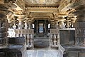
Vestibule ( mandapa )

central space of the lobby

Cantilever dome with hanger

Entrance portal to the cella


- The significantly smaller, but built around the same time, Billeshwara Temple is also dedicated to Shiva; the vestibule (mandapa) is missing. The tower structure above the cella, which is decorated by a ceiling rosette, as well as its stepped and richly relief portal with another Gajalakshmi motif are remarkable. The lingam is over 1 m high.
- In the area of the former fort are a Jain temple and a Virabhadra temple. Both are in need of restoration.