Bijapur
| Bijapur ಬಿಜಾಪುರ |
||
|---|---|---|
|
|
||
| State : |
|
|
| State : | Karnataka | |
| District : | Bijapur | |
| Sub-district : | Bijapur | |
| Location : | 16 ° 50 ' N , 75 ° 43' E | |
| Height : | 600 m | |
| Area : | 97.5 km² | |
| Residents : | 327,427 (2011) | |
| Population density : | 3358 inhabitants / km² | |
| Website : | Vijayapura | |
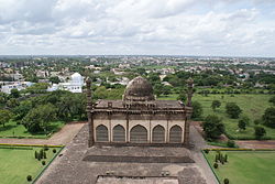
| View of Bijapur from Gol Gumbaz | ||
Bijapur ( Kannada : ಬಿಜಾಪುರ Bijāpura , Urdu : بیجاپور Bījāpur ), officially Vijayapura since 2014, is a city in the Indian state of Karnataka with around 330,000 inhabitants. It is located in the north of Karnataka and is the administrative seat of the district of the same name . From 1490 to 1686, Bijapur was also the capital of an empire of the same name , one of the five Deccan sultanates .
location
Bijapur lies at an altitude of around 600 m above sea level. d. M. on the Dekkan Plateau in the north of the state of Karnataka not far from the border with the neighboring state of Maharashtra . The distance from Bangalore is around 525 km (driving distance) north of Bangalore, Mumbai is almost 500 km in a north-westerly direction. The climate is warm; Rain almost only falls in the summer monsoon months .
population
Official population statistics have only been kept and published since 1991.
| year | 1991 | 2001 | 2011 |
|---|---|---|---|
| Residents | 186,939 | 253,891 | 327,427 |
A good 62% of the majority of the Kannada and Urdu- speaking population are Hindus , around 35.5% are Muslims and around 1% belong to the Jains religious group ; other religions such as Sikhs , Buddhists , Christians etc. form numerically small minorities. The male population is around 2% higher than the female.
economy
The area around Bijapur is used for agriculture; Craftsmen, traders and service providers of all kinds have settled in the city itself. There is a significant cement industry , but there are also sugar refineries .
history
Bijapur was born in 10/11. Century, at the time of the Chalukya dynasty of Kalyani, as Vijayapura ("Victory City"). Towards the end of the 13th century, the city came under Islamic rulers for the first time , namely the Khilji dynasty of the Sultanate of Delhi . In 1347 she came to the Bahmani Sultanate , which split off from the Delhi Sultanate that year. At the end of the 15th century the Bahmani Sultanate fell into disrepair, so that in 1490 Bijapur under Yusuf Adil Shah was able to declare itself independent. During its time as an independent sultanate under the Adil Shahi dynasty, Bijapur experienced a cultural boom. The numerous magnificent buildings of this era bear witness to this to this day. Independence ended in 1686 with the subjugation of Mughal Mughal Aurangzeb . However, the north Indian rulers were again unable to gain a permanent foothold on the Deccan . In 1724 the Nizam of Hyderabad declared its territory to be independent. Bijapur stayed with Hyderabad until the Marathas conquered it in 1760.
With the final victory of the British over the Marathas in 1818, Bijapur also fell to the British East India Company . This allowed the existence of a marathic vassal state called Satara, to which Bijapur was also subordinate. However, Satara was dissolved in 1848 and the city remained part of the British Presidency of Bombay until 1947, the year of Indian independence . In the course of the reorganization of the federal states according to language borders, Bijapur was assigned to the princely state of Mysore in 1956 , which has been called Karnataka since 1973 .
On the occasion of the 50th anniversary of the founding of the state in 2006, the government of Karnataka decided, following a proposal by the writer UR Ananthamurthy , to rename Bijapur to its original name Vijayapura - the Indian central government under Prime Minister Manmohan Singh initially did not agree to the name change; Only under the government of Prime Minister Narendra Modi , which was newly elected in 2014 , did the renaming officially take effect on November 1, 2014.
Attractions
- Gol Gumbaz
The Gol Gumbaz is one of the most famous buildings in India. The huge dome structure - at the time of construction, its dome was about 37 m in diameter after that of the Pantheon , the Duomo in Florence and St. Peter's Basilica in Rome - was built in 1659 as a tomb for Sultan Mohammed Adil Shah, who had died two years earlier built. The 51-meter-high dome is supported by a rather simple, but in its dimensions impressive, square building, which in turn is bordered at each corner by a seven-story corner tower.
The sarcophagi of the sultan and some family members stand on a pedestal in the middle of the huge hall . The actual graves are located in an underground burial chamber. The so-called “ whispering gallery ” runs under the dome , in which multiple echoes can be heard.
- Ibrahim Rauza
The building located just outside the walled old town is the tomb of Ibrahim Adil Shah II (r. 1580–1627), his wife and some other relatives. Much smaller than the Gol Gumbaz , it is less impressive because of its dimensions than because of the fine decorations and elegant domes and minarets .
- Bara Kaman
The huge, but unfinished mausoleum for Ali Adil Shah II due to internal and external problems of the state, was built in 1672.
- Friday Mosque ( Jama Masjid )
Ali Adil Shah I (r. 1558–1579) had the largest Friday mosque in India built in terms of area ; however, it was never completed. Under Aurangzeb it was extended around 1680 by an isolated gate in the east, but the minarets are still missing today.
- citadel
The citadel of Bijapur is largely in ruins today. However, some interesting buildings have been preserved, including the Gagan Mahal , the sultan's palace, which was built in 1561 . The older palace building Sat Manzil , however, is only a ruin. A graceful water pavilion surrounded by gardens has been preserved across from it. There are also two smaller mosques within the citadel. The older Karimuddin Mosque probably dates back to the early 14th century.
- Asar Mahal
In the immediate vicinity of the citadel is the Asar Mahal , built in 1646 as a court of law. Two whiskers of the Prophet Mohammed were temporarily kept there. The frescoes inside, which are not accessible to women, are worth seeing.
- Malik-e-Maidan
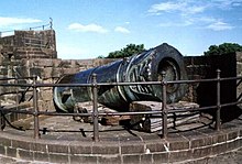
The mighty Malik-e-Maidan (“ruler of the plains”) cannon , one of the largest in the world, stands on the west side of the only partially preserved city wall . It is around 4.50 m long and weighs 55 tons. The cannon was captured as a war trophy in Ahmadnagar in the 17th century .
- More Attractions
In Bijapur there are other, partly unfinished, mausoleums . The Upri Buruj fortified tower from the 16th century stands on an elevation in the west of the old town and offers a beautiful view of the city. Bijapur's 10 km long city wall is only partially preserved; five city gates testify to the former size of the city. The ornate Mihtar Mahal is also a gate; but it is within the city wall and leads to a small mosque.
Web links
- Monuments in Bijapur - Photos and brief information (English)
- Monuments in Bijapur - black and white photos + tooltips (English)
- Bijapur, history and coins - Photos and brief information (English)


