Belgaum
| Belgaum ಬೆಳಗಾವಿ |
||
|---|---|---|
|
|
||
| State : |
|
|
| State : | Karnataka | |
| District : | Belgaum | |
| Sub-district : | Belgaum | |
| Location : | 15 ° 51 ′ N , 74 ° 31 ′ E | |
| Height : | 760 m | |
| Area : | 94.08 km² | |
| Residents : | 490,045 (2011) | |
| Population density : | 5209 inhabitants / km² | |
| Website : | www.belgaumcity.mrc.gov.in | |
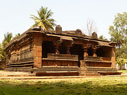
| Jain temple in the fortress of Belgaum | ||
Belgaum , officially Belagavi since 2014 ( Kannada : ಬೆಳಗಾವಿ Beḷagāvi [ ˈbeɭʌɡaːʋi ]; Marathi बेळगांव Beḷgāṃv [ ˈbeːɭɡɑ̃ːo ]) is a city in the southwestern Indian state of Karnataka with around 490,000 inhabitants (2011 census).
It is located in the western highlands of Dekkan , on the edge of the Western Ghats near the border with Maharashtra and Goa , at an altitude of 750 meters above sea level and is about 90 kilometers from the coast of the Arabian Sea . Belgaum is the administrative seat of the Belgaum district . A large part of the population speaks the Indo-Aryan Marathi, the official language is the Dravidian Kannada.
On the occasion of the fiftieth anniversary of the founding of the state in 2006, the government of Karnataka decided, following a proposal by the writer UR Ananthamurthy , to rename the English name of the city to its Kannada name form Belagavi . The Indian central government under Prime Minister Manmohan Singh initially did not agree to the name change. Only under the government of Prime Minister Narendra Modi , who was newly elected in 2014 , did the renaming officially take effect on November 1, 2014.
history
Belgaum emerged at the end of the 12th century when the Ratta dynasty moved their capital from nearby Saundatti . The ratta are mentioned in an inscription from 1199 on a column of the Friday mosque. Another inscription from 1261 indicates the Yadava , which Belgaum conquered around the middle of the 13th century. In the early 14th century the city fell temporarily to the Sultanate of Delhi , soon after to the Hindu Empire Vijayanagara and in 1474 to the Bahmanids , whose crumbling rule was replaced in 1490 by the Adil Shahi of Bijapur . The Adil Shahi expanded the fortress from the Ratta period. In the late 17th century subjugated Mughal emperor Aurangzeb Bijapur and Belgaum also that temporarily took the name Azamnagar. The Marathas followed in the early 18th century . These were finally defeated in 1818 in the Third Marath War by the British , who incorporated Belgaum into the Bombay presidency and used it as an infantry base.
After India's independence in 1947, Belgaum was initially part of the state of Bombay . When the Indian states were reorganized in 1956 according to the language borders, the affiliation to Belgaum, where both Kannada and Marathi were common, became a matter of dispute. In the Taluk Belgaum at that time, Marathi speakers made up a slight majority of 51.4 percent. However, eight of the eleven Taluks in the Belgaum district were predominantly kanada-speaking. Ultimately, Belgaum City came through the States Reorganization Act along with most of the district to the Kannada-speaking state of Mysore, which was renamed Karnataka in 1973 . To this day, the question of Belgaum's affiliation causes tension between Karnataka and the Marathi-speaking state of Maharashtra . In response to Maharashtra's claims, the Karnataka government decided to give Belgaum the status of a “second capital” of the state.
population
According to the 2011 census, Belgaum has 490,045 inhabitants. 73 percent of the population are Hindus , 21 percent Muslim , 4 percent Jain and 1 percent Christian . The most widely spoken language is Marathi , the language of the neighboring state of Maharashtra, which, according to the 2001 census, is spoken by 38 percent of Belgaum's residents as their mother tongue. Kannada , the main language of Karnataka, comes in second with 36 percent. Urdu (18 percent) is also widespread among Muslims . Smaller minorities speak Hindi (3 percent) and Telugu (2 percent).
Economy and Infrastructure
Belgaum is an important regional industrial location. One of the largest alumina plants in India is located in the city . Mechanical engineering (engines, vehicle parts, hydraulic pumps, valves) and, to a lesser extent, the manufacture of textiles and the food industry are also important.
Belgaum is connected to the National Highway 4 between Pune and Bengaluru as well as to the national rail network. In Sambre, about ten kilometers west of the city, there is a regional airfield with regular connections to Mumbai and several major cities in the Deccan.
The city is also the location of the Indian army and a military airfield .
Attractions
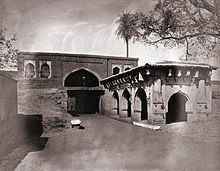
The most important attraction of the city is the fortress from the early 13th century, which was rebuilt and expanded many times by later rulers. It received its present form largely in the 16th century. Within the fortress walls are the Jaina temple Kalama Basti in the late Chalukya style, the Safa mosque and the Friday mosque ( Jama Masjid ) from the 16th century.
Web links
Individual evidence
- ^ Census of India 2011
- ^ S. Rajendran: Center mum on 'Bengaluru' ,. The Hindu , December 18, 2007, accessed October 30, 2015 .
- ↑ Mugdha Variyar: Bangalore, Mysore, Karnataka Other Cities to be Renamed on 1 November. International Business Times, October 18, 2014, accessed October 30, 2015 .
- ↑ Report of the States Reorganization Commission, New Delhi 1955, pp. 97-98.
- ^ Times of India: Decision on second capital status for Belgaum soon, April 13, 2010.
- ^ Census of India 2011: C-1 Population By Religious Community. Karnataka.
- ↑ Census of India 2001: C-16 City: Population by Mother Tongue (Karnataka), accessed under Tabulations Plan of Census Year - 2001 .


