
National Highway 4 (India)
| National Highway NH4 in India | |

|
|
|
|
|
| map | |
.png) |
|
| Basic data | |
| Operator: | National Highways Authority of India |
| Overall length: | 1,235 km |
|
States : |
|
National Highway 4 ( NH 4 ) is a major trunk road in the west and south of the state of India . The route connects four of India's most populous cities - Mumbai , Pune , Bangalore and Chennai and has a length of 1,235 km. It runs through the states of Maharashtra , Karnataka , Andhra Pradesh and Tamil Nadu .
NH 4 forms around 90% of the Mumbai – Chennai section of the Golden Quadrilateral , a motorway project connecting the cities of New Delhi , Chennai, Mumbai and Kolkata . As part of this project, the NH 4 was expanded from a single lane with two lanes to a two-lane street with four lanes. Within the state of Karnataka, the route is also known as the Pune-Bangalore Road. The Mumbai-Pune section was supplemented by the Mumbai Pune Expressway in 2002 .
The highway runs through Satara , Karad , Kolhapur , Belgaum , Dharwad , Hubli , Davangere and Tumkur in Maharashtra and Karnataka . Between Bangalore and Chennai, the trunk road is supplemented by the national highways NH7 and NH46 .
The Pune bypass is a six-lane road with two-lane residential streets that run parallel to the main carriageways on both sides. The city of Katraj is crossed by a tunnel.
NH4 passes the towns of Sangli and Miraj around 40 km away .
Reorganization of the National Highway numbering
In May 2010 the Indian government adopted a new system for numbering national highways . The nationwide implementation of the new system, which is supposed to lead to easier orientation, has been delayed, however. (As of November 2011)
gallery
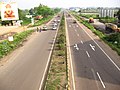
Bypassing Pune
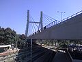
Old Madras Road suspension bridge , National Highway 4, over Krishnarajapuram train station

National Highway 4 at Thiruvalam , Tamil Nadu


Web links
- NH 4 on Google Maps
- Map of the NH4 on the National Highways Authority of India website
- NH 4 at MapsofIndia.com
- Ministry of Road Transport and Highways : Rationalization of Numbering Systems of National Highways (PDF; 3.4 MB)
- Ministry of Road Transport and Highways : Start and end points of the National Highways