Chitradurga
| Chitradurga ಚಿತ್ರದುರ್ಗ |
||
|---|---|---|
|
|
||
| State : |
|
|
| State : | Karnataka | |
| District : | Chitradurga | |
| Sub-district : | Chitradurga | |
| Location : | 14 ° 13 ' N , 76 ° 24' E | |
| Height : | 726 m | |
| Area : | 29.5 km² | |
| Residents : | 145,853 (2011) | |
| Population density : | 4944 inhabitants / km² | |
| Website : | www.chitradurgacity.mrc.gov.in | |
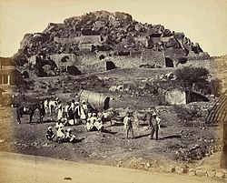
| Historical view of Fort Chitradurga | ||
Chitradurga ( Kannada : ಚಿತ್ರದುರ್ಗ Citradurga [ ˈtʃit̪rʌd̪urɡʌ ]; also: Chitradurg , previously Anglicized Chitaldroog ) is a city in the Indian state of Karnataka with around 145,000 inhabitants (2011 census).
It is located in central Carnataka around 200 kilometers northwest of the capital Bangalore . The city is the administrative seat of the Chitradurga district .
At Chitradurga a chain of hills rises from the otherwise flat plateau in the area, running in a north-south direction. This reaches its highest point at the 1,159 meter high Jogimaradi mountain south of Chitradurga. The city itself lies at the foot of the 984-meter-high Chitradurga rock, on the top of which there is a fortress. The city owes its name to Fort Chitradurga, which means something like "picturesque fortress". Fort Chitradurga was the seat of the nayaks of Chitradurga, who were appointed military governors by the rulers of the Vijayanagar Empire in the 15th century . After the fall of Vijayanagar, the Nayaks went into business for themselves in the 16th century, before Hyder Ali , the ruler of Mysore , conquered the fort in 1779.
According to the 2011 census, Chitradurga has 145,853 inhabitants. 69 percent of the population are Hindus , 29 percent are Muslims, and about 1 percent each are Jains and Christians . The main language is Kannada , which according to the 2001 census is spoken by 62 percent of the population as their mother tongue. Urdu (26 percent) is common among the Muslim minority . Smaller minorities speak Telugu (7 percent), Hindi, and Marathi (2 percent each).
Chitradurga is located on the national highway NH 4 from Chennai via Bangalore to Mumbai . In addition, the city is connected to the railway network via the branch line Birur - Bellary .
Web links
- Chitradurga City Municipal Council (City Council)
- Imperial Gazetteer of India. London 1908. Keyword: Chitaldroog Town. Volume 10, p. 297.
Individual evidence
- ^ Census of India 2011.
- ^ Census of India 2011: C-1 Population By Religious Community. Karnataka.
- ↑ Census of India 2001: C-16 City: Population by Mother Tongue (Karnataka), accessed under Tabulations Plan of Census Year - 2001 .

