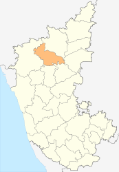
Bagalkot (District)
| Bagalkot District ಬಾಗಲಕೋಟೆ ಜಿಲ್ಲೆ |
|
|---|---|

|
|
| State | Karnataka |
| Division : | Belgaum |
| Administrative headquarters : | Bagalkot |
| Area : | 6,565 km² |
| Residents : | 1,890,826 (2011) |
| Population density : | 288 inhabitants / km² |
| Website : | bagalkot.nic.in |
The Bagalkot district ( Kannada : ಬಾಗಲಕೋಟೆ ಜಿಲ್ಲೆ ; also Bagalkote ) is a district in the Indian state of Karnataka . The administrative seat is the eponymous city of Bagalkot .
geography
The Bagalkot district is located in the north of Karnataka. Neighboring districts are Belgaum in the west, Bijapur in the north, Raichur in the east, Koppal in the southeast and Gadag in the south.
The area of the Bagalkot district is 6,565 square kilometers. The district area belongs to the highlands of Dekkan and has an average height of 550 meters above sea level. In the north, the Krishna River forms the border of the district. On the border with the Bijapur district, the Krishna is dammed up into a reservoir by the Almatti dam . Furthermore, the two Krishna tributaries Malaprabha and Ghataprabha flow through the district area .
The Bagalkot district is divided into the six taluks Jamkhandi, Bilgi, Mudhol, Badami, Bagalkot and Mungund.
history
The area of today's Bagalkot District was the heartland of the early Chalukya Empire between the 6th and 8th centuries . The first capital was Aihole before the capital was moved to Vatapi, today's Badami , in the middle of the 6th century . The last capital was Pattadakal from the end of the 7th century . In 754 the empire was defeated by the Rashtrakutas , former vassals from the north. Subsequently, the area was under the rule of numerous changing dynasties.
In 1818 the area of today's Bagalkot district came under British rule as a result of the Third Marathas War . It was as part of the district Bijapur in the province of Bombay incorporated. Some of the Marathi kingdoms remained as nominally independent princely states under British sovereignty. The princely states of Jamkhandi and Mudhol were in what is now the Bagalkot district . When, after Indian independence, the states were reorganized according to the language borders through the States Reorganization Act , the area came to the Kannada-speaking state of Mysore in 1956 (renamed Karnataka in 1973 ). As an independent district, the Bagalkot district was separated from the Bijapur district in 1997.
population
According to the 2011 Indian census, the Bagalkot district has 1,890,826 inhabitants. Between 2001 and 2011, the population grew by 13.4 percent and thus slightly lower than the average in Karnataka (15.7 percent). The population density of 288 people per square kilometer is below the state average (319 people per square kilometer). 31.7 percent of the residents of the Bagalkot district live in cities. At 69.4 percent, the literacy rate is below average (Karnataka's average is 75.6 percent).
According to the 2001 census , Hindus make up the majority of the residents of the Bagalkot district with 86.2 percent. There is also a larger Muslim minority of 11.1 percent and a smaller minority of Jainas (1.4 percent).
Attractions
As the center of the early Chalukya Empire, the Bagalkot district is rich in monuments from that era. In the former Chalukya capitals of Aihole , Badami and Pattadakal as well as the city of Mahakuta , which are only a few kilometers apart in the Bagalkot district, there are numerous temple buildings from the 6th to 8th centuries. The Chalukya temples in the Bagalkot district are among the most important of the early Indian stone temples and shaped the style of the further development of Indian temple construction. The temples of Pattadakal counts since 1987 for World Heritage of UNESCO .
The temple complex of Kudalasangama , located at the confluence of the rivers Krishna and Malaprabha, is less of architectural than religious importance . Here is the tomb ( samadhi ) of Basava , who founded the Lingayat or Virashaiva sect in the 12th century . Therefore, Kudalasangama is an important pilgrimage destination for followers of this belief.
Cities
| city | Population (2001) |
|---|---|
| Badami | 25,851 |
| Bagalkot | 91,596 |
| Bilgi | 15,464 |
| Guledgudda | 33.991 |
| Hungund | 18,035 |
| Ilkal | 51,956 |
| Jamkhandi | 57,887 |
| Kerur | 17.206 |
| Mahalingpur | 30,861 |
| Mudhol | 42,443 |
| Rabkavi Banhatti | 70,242 |
| Terdal | 23,642 |
Web links
- District Web site Bagalkot (English)
Individual evidence
- ↑ Census of India 2011: Provisional Population Totals: Data Sheet (PDF; 1.7 MB) and Population and decadal growth rate by residence Persons. (PDF; 1.3 MB)
- ^ Census of India 2001: Basic Data Sheet. District Bagalkot (02), Karnataka (29). (PDF; 55 kB)
- ↑ Census of India 2001: Population, population in the age group 0-6 and literates by sex - Cities / Towns (in alphabetic order) ( Memento from June 16, 2004 in the Internet Archive )


