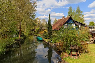
Hechtgraben (Lehder Graben)
|
Hechtgraben / Giglitza Giglica |
||
|
The Hechtgraben in Lehde |
||
| Data | ||
| Water code | DE : 5825399964 | |
| location | Oberspreewald , Niederlausitz , Brandenburg , Germany | |
| River system | Elbe | |
| Drain over | Lehder Graben → Spree → Havel → Elbe → North Sea | |
| Branch | south of Lehde from the Spree 51 ° 51 ′ 33 ″ N , 13 ° 59 ′ 33 ″ E |
|
| Source height | approx. 52 m above sea level NHN | |
| muzzle | in Lehde in den Lehder Graben Coordinates: 51 ° 51 '45 " N , 13 ° 59' 27" E 51 ° 51 '45 " N , 13 ° 59' 27" E |
|
| Mouth height | approx. 54 m above sea level NHN | |
| Height difference | approx. -2 m | |
| Bottom slope | approx. -4.69 ‰ | |
| length | 426 m | |
| Catchment area | 5.1 ha | |
The Hechtgraben , Giglica in Lower Sorbian , alternatively also known as Giglitza , is a 426 meter long river in the Spreewald .
location
The Hechtgraben is located in the Oberspreewald of the Spreewald biosphere reserve and is therefore part of Lower Lusatia . It is also completely within the boundaries of the Spreewald village of Lehde and thus belongs to the urban area of Lübbenau / Spreewald . The Hechtgraben branches off from the Spree south of Lehde , at this point the hatch flows into the Spree when coming from the south . After about 230 meters, Lehde begins on both sides of the Hechtgraben. The houses on both sides of the river can only be reached by barge over the Hechtgraben, the name An der Giglitza is used for the addresses of these houses .
One of the first buildings in Lehde is the Logierhaus (An der Giglitza 3b) on the western side of the Hechtgraben. On its further course, the Hechtgraben also flows past the Spreewaldmuseum Lehde (An der Giglitza 1). Directly behind it it flows into the Lehder Graben .
Individual evidence
- ↑ River directory gewnet25 (Version 4.0, April 24, 2014) at the Ministry for Rural Development, Environment and Agriculture of the State of Brandenburg, accessed on June 26, 2020.
