Spreewald


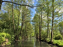
The Spreewald ( Lower Sorbian Błota , "the marshes") is an extensive lowland area and a historical cultural landscape in the southeast of the state of Brandenburg . The main feature is the natural branching of the river Spree , which has been significantly expanded by the canals. As a floodplain and moorland landscape , it is of supraregional importance for nature conservation and is protected as a biosphere reserve (see Spreewald Biosphere Reserve ). The Spreewald as a cultural landscape was decisively shaped by the Sorbs . The area is one of the most famous and popular travel destinations in the state of Brandenburg.
geography
structure
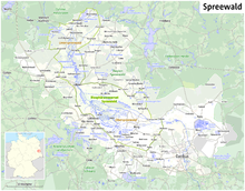
The Spreewald is located in the districts of Spree-Neisse , Dahme-Spreewald and Oberspreewald-Lausitz . It is divided into the southern and larger Oberspreewald and the northern, smaller Unterspreewald. Between the two partial landscapes, the Spree unites over a short distance in the city of Lübben .
The southern boundary of the Spreewald is the Lausitzer Grenzwall , which, however, rises only very gradually from the Spreewald to its main heights further south. In the north, the transition to the dry Lieberoser Heide forms a distinctive landscape boundary . The eastern and western borders of the Oberspreewald are somewhat blurred, as the Baruther glacial valley continues there. The Cottbus-Nord opencast mine now forms the artificially created eastern border. In the Unterspreewald, the Krausnicker Mountains in the west and the Marienberg in the east form landmarks that can be seen from afar. In contrast to the Oberspreewald, the smaller Unterspreewald does not completely fill the valley here and is restricted to the western part. The Neuendorfer See is generally accepted as the northern border of the Spreewald. The branching of the river does not end until a few kilometers to the east where the Pretschener Spree joins the main Spree.
Geology and geomorphology
The landscape was how completely, Brandenburg in the current ice age formed. While the adjoining heights of the Lausitz border wall to the south were formed by the ice advances during the penultimate, the Saale Ice Age , the Spreewald and the areas adjoining it to the north emerged in the subsequent Vistula Ice Age . The Spreewald belongs to the southernmost young moraine region . While the Unterspreewald was still completely covered by the youngest inland ice , the ice in the Oberspreewald reached its maximum extent to the south. However, this advance was of little effect, so that there are no visible traces on the surface. The typical elements of the glacial series can only be found north, on the Lieberoser Heide and on the Krausnicker Mountains , with terminal moraines and sand .
The Oberspreewald itself lies entirely in the Baruther glacial valley , which carried the melt waters of the inland ice to the west. The Unterspreewald, on the other hand, lies in a glacial valley that was created when the meltwater left the Baruther glacial valley to the north. The reason for this is considered to be a gap in the terminal moraine and the low position of the back country. Both the glacial valley and the valley to the north are built up by mighty sands. Only at Leipe is there an island-like marl from the Saale Ice Age. Due to its location in the glacial valleys, the landscape of the Spreewald is extremely flat and almost flat. Only a few dunes , which were blown up from the sands after the meltwater had dried up, rise above the plain around Lübben and in the Unterspreewald. Somewhat elevated and therefore not marshland areas are called Kaupen .
The comparatively small Spree now flows through the extensive lowlands that were not created by it but by the much larger melt waters of the glacial stream. Their gradient is therefore extremely small. Between Cottbus and the Neuendorfer See (approx. 70 km running distance) it is only 15 m.
In the post-ice age , the Spree initially flowed as a meandering rather than a branched river through what is now the Spreewald area. Only the emergence of the characteristic branching of the river, known in the technical language as an anastomosing river , led to today's landscape. At the same time there was extensive bog and the formation of the Klock, as the alluvial clay is called in the Spreewald . However, the exact cause and age of the branching of the river in the Spreewald are still not adequately clarified.
Floors
In the Spreewald, soils influenced by groundwater ( hydromorphic soils ) and bog soils predominate. Gleye are mainly found on slightly higher, flood-free locations . Transitional forms to brown earth are common. Vegen are widespread on the flood-affected areas of the eastern Upper Spreewald , but they mostly show transitions to the gley floors. Anmoorgleye and Moorgleye occur on lower lying but not yet marshland areas . Moors , here as fens, are particularly widespread in the western Oberspreewald and Unterspreewald . They interlock over long stretches with the above-mentioned Gley and Vega floors. Almost all bog areas in the Spreewald show signs of soil formation due to the lowering of the groundwater.
climate
The Spreewald, like all of Brandenburg , lies in the transition area from the oceanic climate of Western Europe to the continental climate of Eastern Europe. Due to its low location compared to the northern and southern environs, the Spreewald has the climatic peculiarities typical of lowlands, which are particularly evident in radiation weather conditions.
The coldest month at the Lübben station is January with an average temperature of −0.7 ° C, and the warmest July with approx. 18.2 ° C (period 1901–1950). The annual mean is 8.5 ° C. Due to its low position, the Spreewald area is susceptible to frost, as a cold air lake can form when the weather is radiant . Foggy days therefore occur much more frequently in the Spreewald than in the surrounding area.
The average annual precipitation in the Spreewald is mostly below 550 mm (station Groß Lubolz 521 mm; 1891-1930) with a pronounced summer maximum and winter / spring minimum. However, the surrounding higher areas with total rainfall of 550 mm are only slightly more humid. On the one hand, the causes lie in the modest height differences to the higher-lying slabs. Heights over 100 m are the exception in the vicinity of the Spreewald. The Krausnicker Mountains , which are up to 144 m high to the west, are too small to create an effective rain shadow . In addition, the Baruther glacial valley, in which the Oberspreewald lies, is oriented from west-northwest to east-southeast. This roughly corresponds to the tracks of numerous precipitation areas, so that hardly any rain shadow effects can have an effect.
Hydrology
The many natural rivers and man-made canals have a total length of over 970 kilometers.
Settlements
Total area: 3,173 km², of which around 2,800 km² is in rural areas
Population: approx. 285,000, of which approx. 103,000 are in rural areas
Population density: 84.9 inhabitants / km², of which population density in rural areas approx. 37 people / km²
- Alt Zauche-Wußwerk
- Babow ( Kolkwitz municipality )
- Castle (Spreewald)
- Byhleguhre-Byhlen
- Luebben (Spreewald)
- Lübbenau (Spreewald)
- New grow
- Raddusch
- Straupitz (Spreewald)
- Schlepzig
- Vetschau
Regional peculiarity in mail delivery
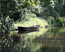
From April to October the post in Lübbenau is delivered by water to the Lehde district. The postmen use a yellow post barge without an outboard motor , which is stalked by a pack . A pack is an ash pole over four meters long that looks like a very narrow oar. Since there is always the risk that the pack will get stuck and break off when pecking, there is at least one replacement pack on each boat.
Utility room
The Spreewald is known throughout Germany as a tourist destination and for the production of natural organic products. The tourist and economic delimitation of the Spreewald is therefore much more difficult than the geographic one. Due to its fame and the associated advantages, the boundaries of the Spreewald tourist or economic area increasingly moved away from the actual Spreewald natural area. The Spreewald economic area was created especially for the regional food industry and is significantly larger than the Spreewald itself. This economic area is protected as a geographical indication within the EU. Before the area was placed under protection, there were several legal disputes over the name Spreewald on food. The so-called cucumber war achieved a certain fame.
Tourist boat trips
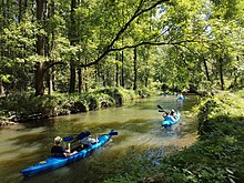
Spreewaldtouristik can find boat trips u. a. from Lübbenau (Großer Kahnhafen, Kleiner Kahnhafen), Lübben , Schlepzig , Straupitz , Burg , Lehde , Raddusch and Neu Zauche . In 1933, 61,000 visitors were punted with the boat. Around the year 1950, 400,000 passengers were counted. By 1975 the number had risen to 1.5 million passengers, 20% of them from abroad. By the mid-1980s, this number had risen to a record figure of around three million passengers a year and was around a million in 2018.
Conservation and endangerment
There are around 18,000 animal and plant species here; In 1991 the Spreewald was recognized by UNESCO as a biosphere reserve .
There are already 830 species of butterflies, 113 mussels and snails and 18 amphibians and reptiles. 48 dragonfly species, 36 fish species, 45 mammal species and 138 breeding bird species have been counted so far. This diversity can be attributed to the numerous types of biotope in the biosphere reserve . These include various forest communities in which black storks, cranes and sea eagles find nesting sites. Types of the open landscape populate meadows and fields, pollard willows and fruit trees. They include marsh and wading birds such as the common snipe and the curlew. They also include the hoopoe , which likes to nest in caves in the old trees, and the typical cultivated bird , the white stork .
The Spreewald is endangered in particular by pollutants from the Lusatian lignite mining area. When iron hydroxide is washed out of the opencast mines , several tons of brown iron ocher sludge are brought into the Spree and other bodies of water every day, which slowly poisons the river fauna and flora. There are also large sulphate inputs. Rivers like the Wudritz , which is already considered dead, are particularly affected .
See also
- Spreewald gherkins
- Cucumber bike path
- Spreeradweg
- Nature reserves Barzlin , Inner Oberspreewald , Inner Unterspreewald
literature
- Burger and Lübbenauer Spreewald (= values of our homeland . Volume 36). 1st edition. Akademie Verlag, Berlin 1981.
- Burger and Lübbenauer Spreewald (= values of the German homeland . Volume 55). 1st edition. Verlag Hermann Böhlaus successor, Weimar 1994, ISBN 3-7400-0933-0 .
- M. Horn, R. Kühner and R. Thiele: The evacuation of the "Merzdorf extensions" in the Cottbus-Nord opencast mine and its relationship to the extent of the Vistula ice in southeast Brandenburg. In: Brandenburg Geoscientific Contributions. Volume 1/2, Kleinmachnow 2005, pp. 37-44.
- O. Juschus: The young moraine south of Berlin. Investigations on the early Quaternary landscape development between Unterspreewald and Nuthe. In: Berlin Geographical Works. Volume 95, Berlin 2003, ISBN 3-9806807-2-X .
- Anja Pohontsch, Mirko Pohontsch, Rafael Ledschbor, Guido Erbrich: Where the Wendenkönig has hidden his treasures - on the move in the Sorbian Lower Lusatia. Domowina-Verlag, Bautzen 2011, ISBN 978-3-7420-1985-1 .
- Jo Lüdemann: Spreewald. A travelguide. 2., revised. Edition. Green Heart, Ilmenau 2011, ISBN 978-3-929993-92-9 .
- Kerstin and André Micklitza: Spreewald - On the way between Burg, Lübbenau, Lübben and Schlepzig. 5th edition. Trescher Verlag, Berlin 2019, ISBN 978-3-89794-485-5 .
Web links
- Link catalog on the subject of "Spreewald" at curlie.org (formerly DMOZ )
- Regional portal Spreewald
- About the creation of the Unterspreewald
- Landscape profile Spreewald of the Federal Agency for Nature Conservation ( information )
Individual references (footnotes)
- ↑ Märkische Tourismuswirtschaft proves to be crisis-proof ( Memento from July 18, 2011 in the Internet Archive )
- ↑ On the history of the river Spree
- ↑ Information on the soil associations is available online on the website of the State Office for Mining, Geology and Raw Materials of the State of Brandenburg
- ↑ Data from M. Hendl: The climate. In: H. Bramer, M. Hendl, J. Marcinek, B. Nitz, K. Ruchholz , S. Sloboda: Physical Geography Mecklenburg-Western Pomerania, Brandenburg, Saxony-Anhalt, Saxony, Thuringia. Gotha 1991, ISBN 3-7301-0885-9 .
- ↑ The mail comes across the water. In: The world . April 16, 2007, accessed May 30, 2015 .
- ^ Information on the cucumber war ( memento of April 21, 2008 in the Internet Archive ) on the former website of a company based in Golßen
- ^ Jörg R. Mettke: GDR: Idyll behind the death strip . In: Der Spiegel . No. 40 , 1975 ( online ).
- ↑ Impending ecological catastrophe in the Spreewald: Emergency action against the brown broth. In: Spiegel Online . April 10, 2013. Retrieved April 10, 2013.
Coordinates: 51 ° 54 '50 " N , 13 ° 55' 35" E


