Krausnicker Mountains
The Krausnicker Mountains are a small high area in southern Brandenburg .
Name and geographic location
The Krausnicker Mountains, also known as the Bergspreewald, are named after the southern village of Krausnick . The highest elevation is the Wehlaberg at 144 meters , which lies on the district of Groß Wasserburg . The Krausnicker Mountains form the border between the Spreewald in the southeast and the Dahmeland in the northwest. Both the mountains themselves and the directly adjacent lakes ( Heideseen and Luchsee ) are part of the Spreewald Biosphere Reserve and are a popular destination. The north-western parts (including the Wehlaberges) are in the Heideseen nature reserve .
Emergence
Like all of Brandenburg, the landscape of the Krausnicker Mountains was created in the Ice Age through the formation of the Scandinavian inland ice . The ice advances of the Saale and Vistula ice ages were characteristic of the Krausnicker Mountains . According to the current state of knowledge, the decisive formation as a high area already took place in the Saale Ice Age. The high area is interpreted as a compression moraine . In the following Vistula ice age, the inland ice on the mountains reached its maximum extent to the south. Initially, the ice flowed around the mountains like a river pillar and formed a glacier tongue south of them, coming from the east, in whose basin the Luchsee is now located. Younger terminal moraines , to which the Wehlaberg also belongs, were added to the compression area . There were two large glacier gates on the mountains. From there, an extensive sander was formed west of the Krausnicker Mountains with the fire . From about 80 m above sea level. NN at the Krausnicker mountains he thought about 60 m above sea level. NN to the south-west, before it borders on the Baruther glacial valley , which carried the melt waters further west. Today, on the fire , which was claimed by the Soviet Army during the GDR era , the Cargolifter shipyard used as Tropical Islands is located.
From the glacier gate on the Bunter Stiel (see below) to the north to the Köthener Lake there is an intensely encircled landscape that was created by the thawing of the dead ice blocks that were buried here in large numbers . In the valleys and gullies of this landscape lie the Heideseen , a lake district with six small forest lakes.
After the ice melted, before reforestation, some periglacial phenomena formed on the Krausnicker Mountains , especially dry valleys and wind edges . Only remnants of the originally existing mixed sessile oak forests remain today. Most of the time, pine forests falter on the sandy areas.
Worth seeing
- Due to the extreme height differences for Brandenburg (100 m in less than a kilometer horizontal distance), the mountains are in themselves a worthwhile excursion destination.
- There has been an observation tower on the Wehlaberg since 2003. When the visibility is good, the view extends as far as the Berlin TV tower and the Jänschwalde power plant (each approx. 60 km away).
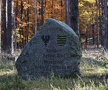
- The border between Saxony and Prussia ran over the Krausnicker Mountains until 1815 . The place name Bunter Stiel , which is today marked by a memorial stone, reminds of the location of the border posts .
- About two kilometers west of the Wehlaberges, another memorial stone on a forest path reminds of the former location of the Hungriger Wolf inn , once a station on the main trade route from Berlin to Cottbus .
- Also worth seeing are the still preserved oaks as remains of the former mixed oak forests.
- The heathland lakes on the Krausnicker Mountains are also a popular destination.
literature
- M. Hannemann: New results on relief design, stratigraphy and glacial dynamics of the Pleistocene in East Brandenburg - Dissertation Department of Geography of the Math. Nat. scientific faculty at the Humboldt University in Berlin. - Berlin 1966
- O. Juschus: The young moraine south of Berlin - Investigations into the young Quaternary landscape development between Unterspreewald and Nuthe. In: Berlin Geographical Works 95 , ISBN 3-9806807-2-X , Berlin 2003
Web links
Coordinates: 52 ° 3 ′ 29 ″ N , 13 ° 48 ′ 3 ″ E


