Luchsee
| Luchsee | ||
|---|---|---|

|
||
| The Luchsee | ||
| Geographical location | Brandenburg | |
| Tributaries | none | |
| Drain | none | |
| Places on the shore | none | |
| Location close to the shore | Krausnick | |
| Data | ||
| Coordinates | 52 ° 2 '38 " N , 13 ° 47' 51" E | |
|
|
||
| Altitude above sea level | 52.7 m | |
| surface | 7.2 ha | |
| length | 300 m | |
| width | 100 m | |
| Maximum depth | 2 m | |
|
particularities |
Total reserve in the biosphere reserve |
|
The Luchsee fills the central part of a moor area in the Brandenburg district of Dahme-Spreewald , approx. 2.5 km northwest of the village of Krausnick .
Origin and structure of the moor
The moor is located in a small glacier tongue basin formed around 20,000 years ago on the Krausnicker Mountains . This is where the main terminal moraine of the Brandenburg stage of the Vistula glaciation runs . The moor is at an altitude of 52.7 m above sea level. NN , is approx. 57 hectares in size and has no natural surface water inflow and outflow. It is only fed by rainwater and groundwater . In the center of the moor is the elongated, 7-hectare Luchsee. This has a depth of less than 2 m. The history of the development of the lynx lake has been well researched by means of pollen analysis drill core investigations. The bog has grown continuously since the subboreal (approx. 5,000 years ago). During the boreal 9,000 to 7,500 years ago, there was a shallow lake here, which was then overgrown by reed and sedge peat . It was only in the last few centuries that peat moss - cotton grass - societies spread on the moor . Recent studies confirm the beginning of sedimentation in the lake as early as the end of the Vistula Ice Age, which ended around 11,600 years ago.
In earlier work, the Luchseemoor was called Kesselmoor . Current studies assume a combination of swamp and silting bog.
Current threat
The water level of the Luchsee has sunk dramatically since the 1990s, so that today it is assumed that the previously assumed lack of underground connection to the aquifer of the Krausnicker Mountains and the Spreewald does not exist. Since the amplitude of the precipitation water and surface water runoff should have remained almost the same in the observed years, it is not assumed that the precipitation conditions are responsible for this trend. Statistical comparisons of the annual total precipitation with the long-term mean of the total precipitation did not reveal any significant anomalies in the amount and distribution of precipitation over the last few years. Rather, it is assumed that an active network of climate change and land use changes has led to a severe lowering of the groundwater. In the case of climate change, the main effect was warming, which leads to increased evaporation. Large areas of the former military airfield in Brand have become forested in recent years, so that evaporation has also increased significantly there. The forest cover, which has become significantly denser in the past few decades, has a similar effect in the immediate vicinity of the moor. An influence of the low water phases of the Spree in the Unterspreewald is also being discussed, since then more groundwater flows from the neighboring plateaus, on which the Luchsee is also located, into the lowlands of the Spreewald.
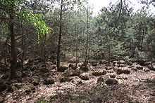
Because of the falling water level, the moor has already largely dried up. Pine trees have largely displaced the original moorland vegetation.
As a total reserve, the Luchsee is a nature reserve and part of the Spreewald biosphere reserve .
See also
swell
- M. Succow , L. Jeschke: Moors in the landscape: origin, household, living world, distribution, use and preservation of moors. Urania-Verlag, Leipzig / Jena / Berlin 1986, ISBN 3-332-00021-7 .
- Andreas Vött Ecosystem changes in the Unterspreewald through mining and amelioration processes - results of an applied ecosystem environmental observation .
- O. Juschus, H. Albert: Sinking lake and groundwater levels in the nature reserve "Luchseemoor" (Spreewald, Brandenburg) - landscape- historical and hydrological findings. In: Current problems in the water balance of northeast Germany: trends, causes, solutions. Scientific Technical Report 10/10. Deutsches GeoForschungsZentrum, Potsdam 2010, pp. 86–92. (PDF file from p. 90; 27 MB)


