Herlinghausen
|
Herlinghausen
City of Warburg
Coordinates: 51 ° 28 ′ 12 ″ N , 9 ° 12 ′ 20 ″ E
|
|
|---|---|
| Height : | 201 m |
| Area : | 2.71 km² |
| Residents : | 446 |
| Population density : | 165 inhabitants / km² |
| Incorporation : | 1st January 1975 |
| Postal code : | 34414 |
| Area code : | 05641 |
|
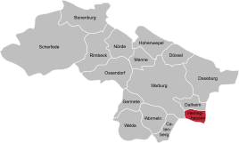
Location of Herlinghausen in Warburg
|
|
Herlinghausen is a district of Warburg in Westphalia with 446 inhabitants. It is located south of the core city on the state border with Hesse .
history
Herlingi , today's Herlinghausen, is mentioned in the founding document of the Neuenheerse women's monastery from May 16, 868 . The place had a close connection with Wettesingen from an early age. There were border disputes between the Landgrave of Hessen-Kassel and the Duchy of Paderborn. In the Hessian-Paderborn Treaty of 1597, Herlinghausen was added to the Paderborn bishopric.
The majority of the population in Herlinghausen is Protestant. Herlinghausen and Hagedorn near Steinheim are the only two villages with a Protestant majority in the area of the former Paderborn Monastery. In Herlinghausen there is a Christian leisure center, the Kirchberghof.
In Herlinghausen there was a Jewish community with a former synagogue and a Jewish cemetery, which is now in the Wettesinger district (Hessen).
On January 1, 1975 Herlinghausen was incorporated into the city of Warburg.
Sons and daughters
- Dieter Nolte (* 1941; † 2010) Hessian politician (SPD)
literature
- Franz Mürmann (1986): Herlinghausen . In: ders. (Ed.): The city of Warburg 1036–1986. Contributions to the history of a city. Volume 2. Warburg: Hermes, pp. 458-459. ISBN 3-922032-07-9 .
Web links
- Herlinghausen website
- Church in Herlinghausen
- Jewish Cemetery
- Herlinghausen in the Westphalia Culture Atlas
Individual evidence
- ^ Federal Statistical Office (ed.): Historical municipality directory for the Federal Republic of Germany. Name, border and key number changes in municipalities, counties and administrative districts from May 27, 1970 to December 31, 1982 . W. Kohlhammer, Stuttgart / Mainz 1983, ISBN 3-17-003263-1 , p. 328 .
