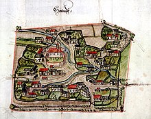
Heudorf near Messkirch
|
Heudorf
City of Messkirch
|
|
|---|---|
| Coordinates: 47 ° 59 ′ 39 ″ N , 9 ° 4 ′ 22 ″ E | |
| Height : | 634 m |
| Area : | 7.87 km² |
| Residents : | 325 (Dec 31, 2012) |
| Population density : | 41 inhabitants / km² |
| Incorporation : | 1st January 1974 |
| Postal code : | 88605 |
| Area code : | 07575 |
|
Location of Heudorf in Meßkirch
|
|
The village of Heudorf is a suburb of the city of Meßkirch with 335 inhabitants (male 164, female 171 [as of Jan. 22, 2015]) in the Sigmaringen district ( Baden-Württemberg ).
geography
Heudorf is about three kilometers west of the city center. The municipal area covers around 787 hectares (as of December 31, 2010). The Dorfbach flows through Heudorf .
history
The Celts settled in the area even before the turn of the ages . A well-preserved Viereckschanze with a side length of 73, 91, 62 and 93 meters can still be found in the Heudorf district in the "Birkstock" forest not far from a sinkhole as evidence of this prehistoric and prehistoric settlement.
The place name Heudorf was first mentioned in 1253 in a document from the Salem monastery .
Until December 31, 1972, the community of Heudorf near Meßkirch belonged to the Stockach district .
On January 1, 1974 the community Heudorf bei Meßkirch was incorporated into the city of Meßkirch.
coat of arms
The blazon of the former municipal coat of arms of Heudorf bei Meßkirch reads: With a silver-blue cloud border of black and silver split and divided three times. The cloud border indicates that it belongs to the Fürstenberg dynasty.
Culture and sights
Buildings
Werner Fischer writes in his chronicle of Heudorf about the three wayside crosses, popularly known as the “three plague crosses”, at the junction of the federal road 311 to Heudorf and Leibertingen-Altheim : “There are reports of plague times in the 15th century. The three plague crosses on Tuttlinger Strasse testify to that ”. Plague crosses were supposed to prevent travelers from entering the place at that time and at the same time urge the stranger to ask and pray for the redemption of the inhabitants from the plague. But they were also set up as thanks after the plague had died down. Presumably these are successor crosses. In fact, the street has always served as an important traffic and travel route here: Probably built as a Roman road , it later served as a post and military road. In 1812 it was laid out as a country road, regulated in 1859 and re-routed to the federal road in 1977/1978. The three wooden crosses show the crucifixion of Christ, the death on the cross on Golgotha and are classified as minor monuments.
societies
- Musikkapelle Heudorf eV
- Country youth Heudorf in the BBL eV
- Modellflugclub Heudorf eV
- Sunshine-Gugge Heudorf / Rohrdorf eV
annotation
- ↑ District area 7,873,727 m²
Individual evidence
- ↑ 2014 population statistics of the city of Meßkirch; accessed on May 17, 2017.
- ↑ Information from Martin Stehmer, Ordnungsamt der Stadt Meßkirch, dated January 12, 2011.
- ^ Hermann Bierl: Archaeological Guide Germany. Ground monuments and museums . Wek-Verlag . Treuchtlingen, Berlin 2007. ISBN 3-934145-39-6
- ^ Federal Statistical Office (ed.): Historical municipality directory for the Federal Republic of Germany. Name, border and key number changes in municipalities, counties and administrative districts from May 27, 1970 to December 31, 1982 . W. Kohlhammer, Stuttgart / Mainz 1983, ISBN 3-17-003263-1 , p. 549 .
- ↑ Plague crosses - plague columns . In: Willi Rößler (Ed.): Field crosses, wayside shrines, memorials and boundary stones in the Sigmaringen district . Geiger-Verlag, Horb am Neckar 2005, ISBN 978-3-86595-043-7 . P. 28f.
- ↑ LAD Tübingen, Reg. 73 D 6


