Himberg (Westerwald)
The Himberg is 335.2 m above sea level. NN high mountain on the edge of the Rheinwesterwald volcanic ridge in the Niederwesterwald . It is located in Aegidienberg , a district of Bad Honnef in the Rhein-Sieg district in North Rhine-Westphalia , between the districts of Himberg in the north and Rottbitze in the southeast. The mountain rises only slightly, at most 30 m, above the surrounding villages and is partly self-built. The type of rock that occurs on the Himberg is alkali basalt , which occurs here in the form of so-called Krotzen .
history
Around 1850 was on Himberg, which used to be 340 m above sea level. NN had (as of 1893) started to mine basalt . Initially operated by tenants from the area (including Christian Uhrmacher), mining was intensified from 1877 onwards by Louis Weinstock from Linz . After the recovered material was first transported by horse-drawn cart through the Schmelztalstraße to Honnef, this was done from 1879 on a newly built narrow-gauge railway to Rottbitze, where there was a loading station that was also approached by the quarry on Dachsberg . The business premises, including workshop and engine shed, were located on the Himberg at around 320 m above sea level. NN height. In 1895 the narrow-gauge railway was extended when crossing the Himberg through the Logebachtal to the Servatiushof and from there as a horse-drawn railway through the Schmelztal to just before Bad Honnef. The branch from the route that tied the quarry directly was about 600 meters southeast of the Himberg.
In 1895, the newly founded basalt trade union Honnef with Weinstock took over the company on the Himberg as a partner, which was expanded from 1897 to include the former mining area of Christian Uhrmacher. Linzer Basalt AG later became the leaseholder of the quarry. From 1905, instead of the route through the Schmelztal, a newly built connecting railway from the Bröltalbahn station in Rostingen to Rottbitze was used for transport. After a shutdown in the First World War , mining on the Himberg was resumed and then stopped again in 1929, with Basalt AG continuing to use the quarry's locomotive shed. In its excavation deepening, after the closure, an excavation water was created that was quickly used as a bathing lake , which was named Hindenburg-See after the National Socialist seizure of power on March 30, 1933 . In 1935, on the occasion of the gravel extraction for the construction of the nearby Reichsautobahn, the quarry was put back into operation and a crusher was built so that the lake had to be drained again.
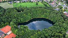
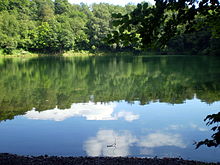
When the quarry was finally shut down in World War II - the lease contract expired on November 1, 1946 anyway - it filled up again with surface water. The excavation water created in this way was named Himberger See ( water level : 318.7 m above sea level ). It is used as a bathing lake and a local recreation area, has an area of 10 hectares and is designated as a landscape protection area and itself covers an area of around 1.5 hectares. In 1960, an elevated tank was built on the Himberger See, which is topographically suitable for this due to its altitude, into which water was pumped from a spring in the southern forest area Im Schwarzen Bruch and then fed into the water pipes for the surrounding villages. In 1970 the Himberger See had a quality class I of very good water quality and had a poorly developed littoral zone . On the Rottbitzer south side of the Himberg, a sports field has been created that goes back to an earlier training camp of the National Socialist Reich Labor Service .
literature
- Carsten Gussmann, Wolfgang Clössner: The Heisterbacher Talbahn and industrial railways in the Siebengebirge: history, vehicles, track plans and maps (= regional traffic history , volume 39). EK-Verlag, Freiburg (Breisgau) 2006, ISBN 3-88255-456-8 , pp. 40-42, 51/52 u. 61-63.
Individual evidence
- ↑ According to the German basic map 1: 5,000 and the State Surveying Office of North Rhine-Westphalia : Topographic map 1: 25,000. 5309 Koenigswinter , Bonn 2000
- ^ Geological State Office North Rhine-Westphalia (ed.); Georg Berg , Otto Burre, Gangolf Knapp (arr.): Geological map of North Rhine-Westphalia 1: 25,000. Sheet 5309 Koenigswinter . 3rd, revised edition, Krefeld 1995.
- ↑ Topographic map (1: 25,000) 1895, based on the Royal Prussian Land Survey 1893
- ^ Ansgar Sebastian Klein : Rise and Rule of National Socialism in the Siebengebirge . Klartext Verlag, Essen 2008, ISBN 978-3-89861-915-8 , p. 179 . (also dissertation University of Bonn, 2007)
- ↑ Information according to the digital terrain model and digital topographic map 1: 10,000 (available in the TIM-online map service )
- ↑ Karl Gast: Aegidienberg through the ages . Aegidienberg 1964, pp. 297-299.
- ↑ Landschaftsverband Rheinland , Landscape Planning Department (ed.); Harald Zepp : Siebengebirge Nature Park. Contents of the present natural and landscape basics (= contributions to regional development , 39). Rheinland-Verlag, Cologne 1982, ISBN 3-792-70706-3 , p. 38.
Coordinates: 50 ° 38 ′ 45 ″ N , 7 ° 18 ′ 19 ″ E

