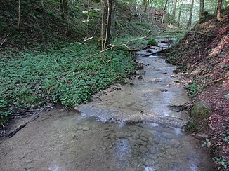
Rear Chrebsbach
| Rear Chrebsbach | ||
|
The rear Chrebsbach just before the riding arena |
||
| Data | ||
| Water code | CH : 23100000 | |
| location | Switzerland | |
| River system | Rhine | |
| Drain over | Töss → Rhine → North Sea | |
| Headwaters | In the Eschenberg near the Eschenberg Tower 47 ° 28 ′ 54 ″ N , 8 ° 44 ′ 1 ″ E |
|
| Source height | approx. 583 m above sea level M. | |
| muzzle | Near the riding arena in the Töss coordinates: 47 ° 28 ′ 32 ″ N , 8 ° 42 ′ 27 ″ E ; CH1903: 695 641 / 259 067 47 ° 28 '32 " N , 8 ° 42' 27" O |
|
| Mouth height | 439 m above sea level M. | |
| Height difference | approx. 144 m | |
| Bottom slope | approx. 49 ‰ | |
| length | 2.9 km | |
| Catchment area | 1.68 km² | |
| Left tributaries | Föhrenbach | |
| Big cities | Winterthur | |
|
The star pond, where the Hintere Chrebsbach flows together with the Föhrenbach |
||
The Hintere Chrebsbach is a 2.9 kilometers long right tributary of the Töss in the urban districts of Stadt and Mattenbach in the south of Winterthur . It rises on the Eschenberg near the Eschenberg Tower , crosses the Bruderhaus wildlife park and flows into the Töss not far from the riding arena .
geography
course
The source area of the brook is about 583 m above sea level. M. on Schneisenstrasse about 100 meters west of the Eschenberg tower. After about 800 meters the brook flows through the lynx , sika deer and red deer enclosure of the Bruderhaus wildlife park over a length of 300 meters.
One and a half kilometers after its source, the stream flows into the small star pond, where it joins the Forrenbach. This is similar in size to the Hintere Chrebsbach and is even a few meters longer.
After the star pond, the Hintere Chrebsbach flows further west, reaches the bottom of the valley at the riding arena and after a small bend flows about a quarter of a kilometer north of the riding arena at an altitude of 439 m above sea level. M. in the Töss.
Catchment area
The catchment area of the Hinterer Chrebsbach is about 1.68 square kilometers. It is the most important of the streams that drain the Eschenberg. Its catchment area lies entirely in the Eschenberg Forest. The 591 m above sea level. The highest point of the catchment area is reached at the Eschenberg Tower , the average height is 527 m above sea level. M.
etymology
Until 1780, the entire length of the Hintere Chrebsbach was run as the Bruderbach - the current name of one of the upper courses.
Web links
Individual evidence
- ↑ a b c GIS browser Canton Zurich, accessed on August 10, 2016
- ↑ Geoserver of the Swiss Federal Administration ( information )
- ↑ catchment area of the rear Chrebsbach. In: Topographical catchment areas of Swiss waters: sub-catchment areas 2km2. Retrieved August 10, 2016 .
- ↑ Jörg Rutishauser: The names of the running waters in the Winterthur district . In: New Year's Gazette of the Winterthur City Library . No. 298 . Buchdruckerei Konkordia, Winterthur 1967, p. 152 .

