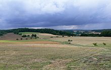
High street between Kocher and Jagst
The Hohe Straße , sometimes also called Hochstraße or Hohstraße , is a historic long-distance trade route that was probably used in the early Celtic times. It runs between Bad Friedrichshall and Heimhausen (Jagst) along the watershed on the ridge between Kocher and Jagst in the Baden-Württemberg part of Franconia and runs through the district of Heilbronn and the Hohenlohe district . In its vicinity there are numerous burial mounds from the Hallstatt period (around 800 to 500 BC), which show that there was already a settlement in the time of the Celts.
course

The Hohe Straße leads from Bad Friedrichshall- Jagstfeld through the Harthäuser Forest and past Diebach to Heimhausen near Mulfingen , crosses the Jagst over the bridge there and then continues towards Rothenburg ob der Tauber . For long stretches the road was or is the border between different territories and markings. Even today, country roads and dirt roads follow the old path in many sections, while elsewhere, especially in forest areas, there are hardly any traces of it to be found.
The fact that the course of the road on the ridge does not align itself with the settlements that were predominantly built in Franconian times indicates that it is much older than these settlement areas. The Romans, on the other hand, are out of the question as the original builders of the road, since the Roman Limes , the eastern border of the Roman Empire , cuts it across halfway through the section from Jagstfeld to Heimhausen. The course of the road leads much further into non-Roman territory.
The route is around 50 km long (45 km as the crow flies).
history
Excavation finds suggest that the ridge between Kocher and Jagst was inhabited as early as the Stone Age. The origins of the long-distance path may lie in this time.
At the time of the Celts, the long-distance trade route played an important role in the salt trade. Important salt towns in the catchment area of the Hohe Straße that were already settled in Celtic times were Niedernhall am Kocher and Kirchberg an der Jagst , to which a smaller offshoot of the street also leads. The Romans , who settled in the Harthausen Forest , laid a military road on part of the Hohe Straße, which connected the forts of Wimpfen and Jagsthausen . That is why the western part of the Hohe Straße is popularly known as the Roman Road . Although the Roman manors in the Harthauser forest were given up around 260 AD, the elevated road remained in use.
In the Middle Ages it was part of a long-distance connection from the imperial cities on the Rhine, especially Worms and Speyer , via the imperial city of Wimpfen am Neckar in the direction of Nuremberg . As the so-called Königstrasse ( Via Regia ) or Kaiserstrasse , it was under the control of the German king or emperor. It is said that in 1235 AD, Emperor Friedrich II took this route to move from Nuremberg to Wimpfen.
Written sources up into the 18th century name escort and customs rights on it.
Numerous, originally orally passed down field names and common names along the course of this interstate road still tell of their existence and former importance. These include names such as An der Hohen Straße , Hochsträßle or Straßenschlag . The field name Leisen is also reminiscent of the old traffic route , derived from the tracks of medieval wagons.
Traditions and legends
Numerous memories of Hohe Strasse have been popularly preserved. A “black” or “fiery man” is said to haunt the Sindeldorf-Diebach intersection, the wild army at Muthof , and the gray rider allegedly roams in the Donnerwald . According to popular belief, several headless or beheaded riders are also up to mischief along the long distance; numerous other legends play in places, forests and grounds in the wider area. Legends let the crusaders move to the Orient on this road. The last great pagan battle against the " Huns " (Hungarians) is said to have been fought on the Ginsberg west of Wendel zum Stein . According to popular belief, such "Huns" are buried in the surrounding barrows.
Tourism
Most of the Hohe Straße can be ridden by bike and some of it can also be hiked. In Schöntal, Hohe Straße is now part of the Paths of Silence , a tourism project of the municipalities of Mulfingen , Dörzbach , Krautheim and Schöntal in cooperation with the Hohenlohe tourism association . Overall, however, this old street and the surrounding Celtic graves are hardly developed as a tourist attraction.
Web links
- The high street. A prehistoric old street between Kocher and Jagst
- High street by the paths of silence
literature
- Emil Kost: The Hohe Straße between Kocher and Jagst . In: Württembergisch Franken . New series 22/23, 1947/48. Historical Association for Württemberg Franconia, Schwäbisch Hall 1949, pp. 47-61.
Individual evidence
- ↑ Course of the road (PDF; 1.4 MB) , accessed on April 10, 2011.
- ↑ Source: Google Earth.
- ^ Emil Kost, The High Street between Kocher and Jagst , (digitized).
- ↑ Paths of Silence at Hohenlohe.de , accessed on April 10, 2011.


