Hohenberg (Grazer Bergland)
| Hohenberg | ||
|---|---|---|
|
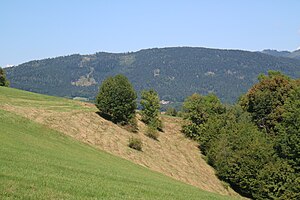
View from the southeast (Linecksattel) |
||
| height | 1048 m above sea level A. | |
| location | near Sankt Radegund near Graz , Styria | |
| Mountains | Grazer Bergland | |
| Coordinates | 47 ° 9 '57 " N , 15 ° 27' 15" E | |
|
|
||
| rock | Schöcklkalk ( Graz Paleozoic ) | |
| particularities | Erhardhöhe 1049 m above sea level. A .; Mura – Raab watershed | |
The Hohenberg is a foothill of the Schöckl in the eastern Grazer Bergland northeast of Graz . The main peak is 1048 m above sea level. A. high, the summit of the Erhardhöhe is 1049 m above sea level. A.
The mountain forms a wooded ridge that stretches in a west-east direction in front of the Schöckl massif. It is connected to the Schöcklstock by the Zwölferkogel ( 1192 m above sea level ). To the west, it falls relatively steeply from the Erhardhöhe into the valley of the upper Andritzbach and the municipality of Stattegg near Buch . Towards the Lebersattel lies the Kreuzkogel ( 816 m above sea level ). To the east the mountain range descends towards St. Radegund , at 910 m above sea level. A high, last elevation, the Novystein monument is visible from afar . The Mühlgrabenbach flows between Hohenberg and Schöckl at Klamm . The valley of the Schöcklbach is located south towards the hill country east of Graz . Here in the municipality of Weinitzen are the villages of Hohenberg and below Weinberg and Oberschöckl at the foot of the mountain. The ridge of Rinnegg stretches southeast between St. Radegund and Weinitzen . The southwest ridge stretches over Gsöllberg ( 843 m above sea level ), Kalkleiten (Kollerniklkogl) and Zösenberg down to between Andritz and Neustift .
The Römerweg , an old road around the Hohenberg towards Semriach and Passail, runs over Rinnegg . This road, which was heavily frequented in the Middle Ages, was guarded by Ehrenfels Castle .
The mountain still belongs to the main mass of Schöckl limestone in the Graz Paleozoic . The back is wooded, this forest is called the Black Forest. The whole ridge lies in the landscape protection area of the northern and eastern hill country of Graz .
Web links
Individual evidence
-
↑ A Roman inscription stone in the parish church of St. Radegund as well as the straight line layout of the route suggest a real Roman mule track into the Passail basin.
Compare Mathias Macher: The cold water sanatorium in St. Radegund am Schöckel near Graz. (The Styrian Graefenberg. ) A guide for spa guests and mountain travelers. Verlag Wilhelm Braumüller, Vienna 1868. 2. Section Parish and local community St. Radegund , Chapter 5. The history of the parish St. Radegund , p. 11 ( Google Books, complete view ); Giancarlo Susini: Notule stiriane. In: Epigraphica 42 (1980). Università di Bologna. Dipartimento di storia antica, pp. 204-206.

