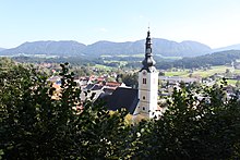
Passail Basin

The Passailer Basin , also known as the Passailer Kessel , is a mountain basin in Styria , in the Grazer Bergland . Three communities - Fladnitz an der Teichalm in the west, the eponymous Passail in the middle and Sankt Kathrein am Offenegg in the east (all of the Weiz district ) - make up the area that is also part of the Almenland region .
It extends around Passail in the south to the Schöckl , in the east to the Patscha , in the northeast to the Plankogel and in the northwest to the Hochlantsch . The highest mountain is the Hochlantsch with 1720 m before the Osser with 1545 m and the Plankogel with 1530 m.
The main river is the Raab with the Raabklamm and its tributary Weizbach with the Weizklamm , which drain to the south. Between the Raabklamm and Weizklamm lies the elongated Sattelberg , to the west with the Gösser walls of the Gösser mountain , followed by the Lärchsattel , the Wachthaussattel and the Wolfsattel to the Weizklamm. In the north are the Teichalm and the Sommeralm . To the west and north of it, the Mixnitzbach drains through the Bärenschützklamm into the Mur .
The most important traffic access from the Murtal leads from the S 35 over the Rechbergpass ( Rechberg Straße B 64 ).
Parts of the basin belong to the Almenland Nature Park . Geologically, the basin belongs to a series of inner-Alpine depressions on the southeastern edge of the Alps north of the Grazer Bay , with the Gratwein-Gratkorner Basin , Reiner Basin and Semriach Basin , of which it is the largest and eastern.
literature
- Sieghard Morawetz : The Passail Basin . In: Communications of the natural science association for Styria . Graz 1988, p. 199–209 ( PDF on ZOBODAT ).
Technical literature:
- Peter Hacker : Results of hydrological investigations and measurements of the environmental isotopes in the catchment area of the Passail Basin (Central Styria) . In: Contributions to Hydrogeology . tape 25 , 1973 ( Index Contribution Hydr. , Joanneum Research ).
- Karl Spreitzhofer : Settlement and ownership history of the Passail basin in Eastern Styria . Phil. Diss. Graz 1976 ( entry list of publications , Hist. Landeskomm. F. St. [accessed on May 15, 2018]).
- Karl Spreitzhofer: The St. Kathrein clearing on Offenegg . A supplement to the "Styrian court descriptions". In: Communications from the Styrian State Archives . tape 34 . Graz 1984, p. 79–85 ( administration.steiermark.at [PDF] legal history).
Maps:
- Austrian map 1: 50,000, sheets 134 Passail , 135 Birkfeld
- f & b hiking map 131 Grazer Bergland-Schöckl-Teichalm-Stubenbergsee 1 :: 50,000 EAN: 9783850847599 (in Neudr. 2/2011, f & b online )
- Geological map of the Republic of Austria 1: 200,000, sheet 134 Passail (Helmut W. Flügel, Hannes Gollner, Hans Gsellmann, Nora Hubauer, Franz Neubauer, et al .: 1982 report on geological surveys on sheet 134 Passail . In: Geologische Bundesanstalt (ed .): Explanation on the GÖK . Vienna 1982. )
Web links
- Sub-region B.10 Passail Basin (basin). In: Umweltinformation Steiermark »Nature and Landscape» Landscape »Landscape Structure. State of Styria - Office of the Styrian Provincial Government, 2010, accessed in 2010 .
- Climatic region B.5 Passail Basin. In: Umweltinformation Steiermark »Climate» Climate regions of Styria. State of Styria - Office of the Styrian Provincial Government, 2010, accessed in 2010 .


