
High Zwiesler
| High Zwiesler | ||
|---|---|---|
 Hoher Zwiesler summit |
||
| height | 1376 m above sea level NN | |
| location | Bavaria , Germany | |
| Mountains | Bavarian Prealps | |
| Dominance | 4.4 km → Gerstenrieder Kopf | |
| Notch height | 664 m | |
| Coordinates | 47 ° 36 '2 " N , 11 ° 32' 23" E | |
|
||
| Normal way | Mountain hike, pathless and unmarked | |

The Hohe Zwiesler is a 1376 m high summit of the Rauchberg ridge in the Bavarian Prealps .
topography
The Hohe Zwiesler is the highest peak of the Rauchberg mountain ridge, which extends between the Jachenau and the Isar north of the Sylvenstein reservoir . In addition to the Hohen Zwiesler, further peaks to the northeast of the Hohen Zwiesler are Paradiesköpfl , Anderlkopf , Mitterkopf and Talkopf and in a south-westerly direction Achselkopf and Brünstkopf . At the northeastern foot of the Rauchberg mountain is the homonymous desert smoke mountain , which belongs to Lenggries.
There is no signposted path leading to the wooded summit. The easiest access is by forest road through the hamlet Rauchberg. The last approx. 200 meters in altitude from the end of the forest path are unmarked and path-free in partly steep terrain. At the highest point there is a trigonometric point ; 30 m below on the north side of the summit, a rock march marks the historical boundary between the Benediktbeuern monastery and the Tölz district court , see list of architectural monuments in Jachenau .
gallery
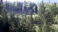
Anderlkopf

Head of Paradise
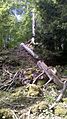
Pathless terrain below the summit

Felsmarch 30 m below the summit on the north side of the Hohe Zwiesler


.jpg)
