Holy Island (Anglesey)
| Holy Island | ||
|---|---|---|
| Map of Anglesey with Holy Island | ||
| Waters | Irish Sea | |
| Geographical location | 53 ° 17 ′ N , 4 ° 37 ′ W | |
|
|
||
| length | 12.3 km | |
| width | 5.6 km | |
| surface | 39.4 km² | |
| Residents | 13,659 (2011) 347 inhabitants / km² |
|
| main place | Holyhead | |
| The northern tip of the island of Anglesey | ||
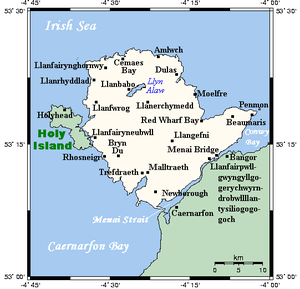
Holy Island (German: Heilige Insel), ( Welsh : Ynys Gybi, the island of Saint Cybi ) is an island west of Anglesey in north Wales . The name Holy Island is based on the fact that there are a number of menhirs , dolmens (the Borthwen Beach Cromlech is a modern replica) and other religious sites on the island . The other, historical name of the island is Holyhead Island . According to the 2011 census, the island has 13,659 residents.
history
Irish pirates invaded Anglesey after the end of Roman rule over England and Wales . The Welsh prince Cunedda began to fight the pirates, but the final victory was Cadwallon Lawhir ap Einion on Holy Island.
landscape
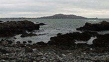
Like Anglesey, Holy Island has a mix of landforms, including mudflats , dunes, beaches, and marshland . Most of the west side of the island is taken up by Holyhead Mountain . The mountain is the highest mountain in County Anglesey at 220 m. The area between Holy Island and Anglesey has been the Beddmanarch-Cymyran Site of Special Scientific Interest (SSSI) since 1961 .
traffic

Holy Island has two road links to Anglesey. One is the Stanley Embankment , a causeway across which the A5 and A55 road links and the main rail line to Chester and Crewe and from there to London and Glasgow, respectively. This is the original route of the A5. The Four Mile Bridge offers another, albeit smaller, road connection to the island.
The main town on the island is Holyhead , from where ferries go to Dún Laoghaire and Dublin in Ireland. Holyhead is the terminus of the North Wales Coast Line railway line.
Approximately 30 miles of the Anglesey Coastal Path , part of the Wales Coast Path , runs on Holy Island.
Lighthouse and shipwrecks
In front of the island are the islands of North Stack and South Stack . There was a fog warning station at North Stack and a lighthouse at South Stack warning of the island's dangerous cliffs, which posed a great threat to shipping, the sinking of the Royal Charter in 1859 being just one example.
See also
Individual evidence
- ↑ Beddmanarch-Cymyran SSSI ( Memento of the original from October 4, 2013 in the Internet Archive ) Info: The archive link was automatically inserted and not yet checked. Please check the original and archive link according to the instructions and then remove this notice. at Countryside Council for Wales, accessed June 26, 2014


