Holzberg (Taunus)
| Holzberg | ||
|---|---|---|
| height | 280 m above sea level NHN | |
| location | near Kransberg ; Hochtaunuskreis , Hessen ( Germany ) | |
| Mountains | Taunus | |
| Coordinates | 50 ° 21 '25 " N , 8 ° 35' 56" E | |
|
|
||
| particularities | - Ringwall wooden castle - Marienkapelle |
|
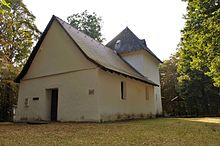
The Holzberg is about 280 m above sea level. NHN high elevation in the Taunus . It is located near Kransberg in the Hessian Hochtaunuskreis ; to the east is the Wetteraukreis . On it are the ring wall wooden castle and the Marienkapelle .
geography
location
The Holzberg rises in the Taunus Nature Park . It is located between the nearby Kransberg (Usingen) in the south-south-west and between Friedrichsthal ( Wehrheim ) in the south-east, Wernborn (Usingen) in the west-north-west and Langenhain-Ziegenberg (Ober-Mörlen) in the east-north-east. The Holzbach flows past to the south and flows west of the elevation into which this north tangent Usa flows.
Natural allocation
The Holzberg belongs to the natural area main unit group Taunus (No. 30) and in the main unit Eastern Hintertaunus (302) to the natural area Münster-Maibach-Schwelle (302.4). The landscape drops to the west into the natural area Usinger Becken (302.5).
Ringwall wooden castle
On the Holzberg there is the Ringwall Holzburg , which dates from around 900 BC. Its ring walls are still clearly visible in the area today. In addition to the finds from this time, other finds from the 4th / 5th were found during excavations. Century.
Deserted Ober- and Unterholzburg
In 1275 two villages on the Holzberg are mentioned in a document: Oberholzburg and Unterholzburg (Hoilzburch) . 1653 is mentioned in a document as Oberholzberg and Unterholzberg. Both places perished in the turmoil of the Thirty Years' War . In 1653 the parish of Holzburg was moved to Kransberg.
Lady Chapel
The Marienkapelle, which was first mentioned in a document in 1218, stands on the Holzberg. It is located in the ring wall wooden castle .
See also
literature
- Hildegunde Trier: The Marienkapelle zu Kransberg. In: Yearbook of the Hochtaunuskreis. 2003, ZDB -ID 2580038-3 , pp. 173-184.
- Reinhard Michel: About the desert in the Hochtaunuskreis . In: Ingrid Berg, Eugen Ernst, Hans-Joachim Galuschka, Gerta Walsh (eds.): Heimat Hochtaunus . Kramer, Frankfurt am Main 1988, ISBN 3-7829-0375-7 , p. 163-171 .
Individual evidence
- ↑ Brigitte Schwenzer: Geographical land survey: The natural space units on sheet 139 Frankfurt a. M. Federal Institute for Regional Studies, Bad Godesberg 1967. → Online map (PDF; 4.9 MB)


