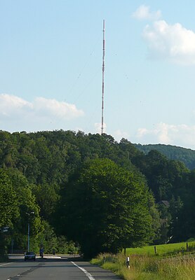
Hordtberg
| Hordtberg | ||
|---|---|---|
| height | 244.4 m above sea level NHN | |
| location | North Rhine-Westphalia , Germany | |
| Coordinates | 51 ° 21 '23 " N , 7 ° 8' 3" E | |
|
|
||
| particularities | - Bismarck Tower ( AT ) - Langenberg transmitter |
|
The Hordtberg is at 244.4 m above sea level. NHN the highest point in Langenberg (City of Velbert ). To the east, the border with the Ennepe-Ruhr district runs over the altitude.
The Hordtberg is characterized by a largely contiguous 120 hectare forest area and has been used mainly for recreational purposes since the 19th century. A wooden observation tower, the 21 m high Hordtberg Tower, was built here as early as 1893, which was replaced in 1906 by the construction of a massive Bismarck tower. In the period that followed, an excursion restaurant was also added. There are several WDR broadcasting systems on the Hordtberg , including the 301 m high Langenberg transmitter . Since the opening of the forest climbing park at the summit in 2009, the Hordtberg has also been attracting numerous visitors.
On the Hordtberg are the Velbert districts and residential areas Am Brill , Bertram , Flasdiek , Hansberg , Meyberg , Niederhordt , Plätzken , Quellberg , Rommel , Sondern , Schwarzer Adler , Thielen , Texas and Übelgünne . In terms of nature, the Hordtberg is part of the Hardenberger hill country (337 1 12).
The valley in the west of the elevation is formed by the Deilbach , east of it flows the Felderbach , which flows north of the ridge to the Deilbach. Several tributaries such as the Hordtbach , the Künningbach , the Quellbergbach , the Kinkhauser Bach / Vogelsbach and the Meybergsbach structure the mountain flanks into deep sieves . Neighboring elevations in the ridge are the Ottoplatte in the south and the Löper Berg in the north. The district road K30 crosses the elevation and connects the transmitter, the localities and the Bismarck tower.
The subsurface of the ridge is formed by folded, clastic rocks from the empty Namurium A and B , which were previously quarried in small quarries for local use. In addition to clay stones , quartzites and gray-wacke banks dominate the structure of the subsoil.
Individual evidence
- ↑ Geoserver NRW (interactive query) , accessed on January 7, 2013
- ↑ a b German basic map 1: 5000
- ↑ Handbook of the natural spatial structure of Germany: Sheet 108/109: Düsseldorf / Erkelenz (Karlheinz Paffen, Adolf Schüttler, Heinrich Müller-Miny) 1963; 55 p. And digital version of the corresponding map (PDF; 7.4 MB)
- ^ Eva Paproth (1960): The Kulm and the empty facies of the Namurs. Status of investigations and open questions. - Progr. Geol. Rheinld. u. Westf., 3,1: 385 - 422, 7 figs., 1 tab., 1 plate; Krefeld
- ^ Geological map of Prussia and neighboring German states, sheet 4608 Velbert, Berlin 1929
Web links
- Bismarck Tower Velbert , accessed on January 7, 2013
- Reconstruction plans for the restoration at the Bismarck Tower , accessed on January 8, 2013
- History of the station Langenberg , accessed on January 8, 2013

