Hrvatska Kostajnica
| Hrvatska Kostajnica | ||
|
||
|
|
||
| Basic data | ||
|---|---|---|
| State : |
|
|
| County : |
|
|
| Height : | 109 m. i. J. | |
| Area : | 55.4 km² | |
| Residents : | 2,756 (2011) | |
| Population density : | 50 inhabitants per km² | |
| Telephone code : | (+385) 044 | |
| Postal code : | 44 430 | |
| License plate : | SK | |
| Structure and administration (as of 2017) |
||
| Community type : | city | |
| Mayor : | Dalibor Bišćan ( HDZ ) | |
| Website : | ||
Hrvatska Kostajnica , often just called Kostajnica , (German outdated Castanowitz ) is a small town in central Croatia .
location
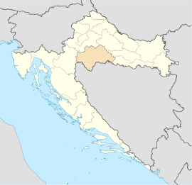
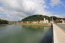
It is located in the Sisak-Moslavina County south of Petrinja and Sisak on the Una River , which forms the border with Bosnia and Herzegovina . On the opposite side of the river is the former border fortress Stari Grad and, behind a silted up river arm, the village of Bosanska Kostajnica , which belongs to the Republika Srpska in Bosnia and Herzegovina. Thus, the state border at this point does not run directly in the Una, but a little south of the river.
population
The population of the municipality Hrvatska Kostajnica was 2,756 people at the 2011 census. The urban area has 2,127 inhabitants. 69.34% of the inhabitants of the municipality describe themselves as Croatians and 25.04% as Serbs .
History of the name
The name is supposedly derived from the term "kostanj" (chestnut, chestnut). Previous names of the city were:
- 1240: Koztainicha
- 1258: Kozstanicha
- 1272: Kaztanicha
- 1351: Coztanycha
- 1362: Costgnanice
- 1600: Castanowiz
traffic
Hrvatska Kostajnica has a stop on the Banja Luka – Sunja railway line . South of the road bridge over the Una is an international border crossing between Croatia and Bosnia-Herzegovina.
Sons and daughters
- Svetozar Boroëvić von Bojna , Austro-Hungarian field marshal


