Hubenhecke
| Hubenhecke | ||
|---|---|---|
|
Hubenhecke |
||
| height | 269.1 m above sea level NHN | |
| location | Heppenheim ; Bergstrasse District , Hesse ( Germany ) | |
| Mountains | Odenwald | |
| Dominance | 0.7 km → Lindenstein | |
| Coordinates | 49 ° 39 '31 " N , 8 ° 38' 49" E | |
|
|
||
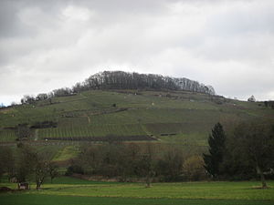
The Hubenhecke in the district Unter-Hambach between the Bergstrasse in the west and the Hambach valley in the east is 269.1 m above sea level. NHN high elevation on the edge of the Odenwald . At the foot of the western slope, viticulture is practiced up to medium heights. The vineyards are in the Heppenheim district and are part of the Hessische Bergstrasse cultivation area . Most of the Riesling is grown, but also Ruländer and Silvaner . The mountain top is covered by a small wood. The Hubenhecke lies entirely in the urban area of Heppenheim in the Bergstraße district in southern Hesse .
The mountain road between Hemsberg (left), Hubenhecke (panorama center) and Starkenburg (right)
Individual evidence
- ↑ Map services of the Federal Agency for Nature Conservation ( information )
- ↑ Heppenheim Wine Experience Trail , accessed on February 10, 2014


