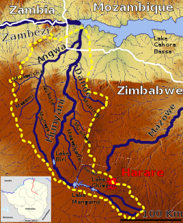
Hunyani
|
Hunyani Manyame River, Rio Panhame |
||
|
The catchment area of the Hunyani |
||
| Data | ||
| location |
|
|
| River system | Zambezi | |
| Drain over | Zambezi → Strait of Mozambique | |
| source | 6 km west of Marondera 18 ° 10 ′ 57 ″ S , 31 ° 29 ′ 13 ″ E |
|
| Source height | 1631 m | |
| muzzle | in the Cahora Bassa reservoir coordinates: 15 ° 42 ′ 21 ″ S , 30 ° 39 ′ 0 ″ E 15 ° 42 ′ 21 ″ S , 30 ° 39 ′ 0 ″ E |
|
| Mouth height | 326 m with full traffic | |
| Height difference | 1305 m | |
| Bottom slope | 5 ‰ | |
| length | 260 km | |
| Catchment area | 25,497 km² (excluding Rukomechi and Musengezi) | |
| Outflow A Eo : 25,497 km² at the mouth |
MNQ MQ Mq MHQ |
0 l / s 26.5 m³ / s 1 l / (s km²) 198 m³ / s |
| Left tributaries | Angwa | |
| Right tributaries | Dande | |
| Reservoirs flowed through | Lake Chivero , Lake Manyames | |
| Medium-sized cities | Chinhoyi | |
The Hunyani is a 260 km long tributary of the Zambezi in Zimbabwe and Mozambique .
course
The river has its source at an altitude of 1,631 m west of Marondera in the province of East Machonaland . It flows north-west into the province of West Maschonaland , where it is dammed just beyond the provincial border to Lake Chivero ( Lage ) and just 20 km further to Lake Manyamesee ( Lage ). From there it flows north to Chinhoyi and on through the semi-arid north through the province of Central Machonaland to Mozambique and there about 25 km below Kanyemba as Rio Panhame in the Cahora-Bassa dam .
Hydrology
The flow rate of the river was measured about 100 km before the mouth in Gururve in almost half of the catchment area (excluding Angwa and Dande) in m³ / s (values read from the diagram).

Reservoirs
The reservoirs of the Hunyani are very popular destinations for the people of Harare . But the Hunyanipoort Dam of the 26 km² Chivero Lake, formerly Lake McIlwaine, was built in 1952 to supply the city with drinking water and the irrigation systems of the estates downstream. The Manyamesee was later dammed, formerly Darwendale's Lake Robertson, which is also used for the drinking water supply of Harares and for fish farming.
Behind these two reservoirs the waters of the Hunyani are almost used up. In the dry season it no longer reaches the Zambezi.
Web links
Individual evidence
- ^ Drought and Flood Risk Assessment on Manyame River Basin, Zimbabweunder Climate Change
- ^ The Zambezi River Basin - A Multi-Sector Investment Opportunities Analysis - Volume 3 State of the Basin
- ↑ Soviet General Staff Map , accessed via http://loadmap.net/
- ↑ Integrated Flood Management - Case Study - Zimbabwe: Flood Management Practices - Selected Flood Prone Areas Zambezi Basin

