
Hurricane Pink (1994)
| Category 2 hurricane ( SSHWS ) | ||
|---|---|---|
 |
||
| Emergence | 8th October | |
| resolution | 15th October | |
|
Peak wind speed |
|
|
| Lowest air pressure | 974 mbar ( hPa ; 28.8 inHg ) | |
| dead | 4 direct, 22 indirect, 4 missing | |
| Property damage | Unknown | |
|
Affected areas |
Mexico , Texas | |
| Season overview: 1994 Pacific hurricane season |
||
Hurricane Rosa was a tropical cyclone in the eastern Pacific Ocean . He killed at least four people in Mexico . The humidity from the hurricane was a contributing factor in the widespread flooding in the state of Texas that resulted in the deaths of 22 and hundreds of millions of dollars in damage in October 1994. Rosa peaked as a hurricane in category two on the Saffir-Simpson hurricane wind scale . Pink was the last hurricane and the nineteenth tropical storm of hurricane season in the eastern Pacific in 1994 .
course

By October 8, circulation combined with a weather disturbance had gained enough convection to be classified as the 19th tropical depression of the year by the National Hurricane Center . Wandering slowly, development was steadily hampered by wind shear and the low pressure area had problems organizing itself. On October 9, the system was so disorganized that the storm warnings were discontinued.
The rest of the lows migrated eastwards and were exposed to another weather disturbance, which restarted the convection, and on October 10th the depression was able to regenerate, possibly with a new circulation center. With little forward movement in a favorable environment, the depression was upgraded to Tropical Storm Rosa on October 11, and a day later to Hurricane. At that time, the center of the system was around 555 km south of the southern tip of Lower California . Rosa continued his slow drift for a day and a half. Then a trough forced Rosa to accelerate and pull away in a north-northeast direction. On October 14, Rosa reached its intensity peak as a Category 2 hurricane on the Saffir-Simpson hurricane wind scale with wind speeds of around 165 km / h and a central air pressure of 974 hPa (mbar). A few hours later after reaching the mainland near La Concepción about 110 km south-southeast of Mazatlán , Rosa's circulation over the mountains weakened and the system disintegrated on October 15.
Preparations and predictions
On October 12, hurricane warnings were triggered for the Mexican coast between Culiacan and Manzanillo and for Baja California south of the 24th parallel. A tropical storm was warned for the stretch of coast between Manzanillo and Tepic . These warnings were changed on October 14th - the hurricane warning now only affected the coast between Culiacán and Cabo Corrientes , between Cabo Corrientes and Manzanillo only one tropical storm was now expected. All warnings were lifted after the storm hit land during October 14th.
The predictions on pink were generally worse than most other systems. In particular, a resolution due to strong wind shear was predicted for the previous gravure printing system. Although the low initially dissolved, the subsequent regeneration was not predicted.
Effects
Mexico

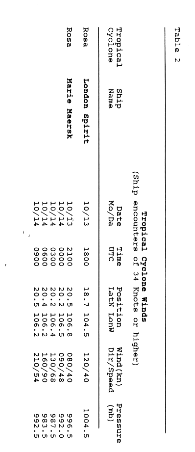
On October 13 and 14, two ships, the London Spirit and the Marie Maersk, reported winds of the strength of a tropical storm or hurricane, with the Marie Maersk being particularly close to Rosa's eye . The measurements from both ships were helpful to the meteorologists.
Two people drowned in each of the states of Nayarit and Durango , and four people went missing in Sinaloa . The homes of more than 100,000 residents in Nayarit were damaged. The wind from the hurricane damaged phone lines, electricity networks and homes in Sinaloa. Rainfall between 75 and 130 mm caused landslides and mudslides in mountainous terrain. This made it necessary to evacuate 400 residents from two villages on the Jalisco coast . Rosa sometimes dumped large amounts of rain on the coast and inland Mexico, with most of the rain at 360 mm measured in Mesa de Pedro Pablo.
United States
Rosa brought an abundant amount of moisture into the United States, which, in conjunction with warm, humid air from the Gulf of Mexico via Texas, led to violent thunderstorms. Thirty-eight counties in the state saw flooding between October 15 and October 19, which were most severe on the San Jacinto River and the Trinity River Basin . The amount of precipitation totaled 200–700 mm. At 19 gauges the precipitation caused floods with a hundred-year probability of recurrence, numerous record levels were exceeded, some of which had existed since 1940 and in the case of Edna on the Lavaca River since 1936. The floods destroyed 3,069 houses, damaged 6,560 badly and caused a further 6,148 minor damage. Railways and highways were eroded, gas and oil pipelines broke, causing oil spills and other environmental damage in the lower reaches of the San Jacinto River and in Galveston Bay . By the natural disaster people were killed twenty-two, the damage in southeast Texas amounted to 700 million US dollars (at 1995 prices). The Federal Emergency Management Agency declared the hardest hit areas a disaster area on October 18, a total of around 26,000 requests for disaster relief were received, and this federal agency disbursed $ 54 million in financial aid.
No deletion of the name
The name Rose was not removed from the list of tropical cyclone names and was therefore reused in 2000 and 2006 and is also planned for 2012.
Web links
- National Hurricane Center : Hurricane Rosa Preliminary Report (English)
- Unisys : Railway map (English) ( page no longer available , search in web archives )
Individual evidence
- ↑ Mayfield: Tropical Depression Nineteen-E Special Discussion 1 ( English ) National Hurricane Center . October 8, 1994. Retrieved October 3, 2008.
- ↑ Mayfield: Tropical Depression Nineteen-E Discussion Number 2 ( English ) National Hurricane Center . October 8, 1994. Retrieved October 3, 2008.
- ↑ Mayfield: Tropical Depression Nineteen-E Discussion Number 1 ( English ) National Hurricane Center . October 8, 1994. Retrieved October 3, 2008.
- ↑ a b c d Lixion Avila : Preliminary Report Hurricane Rosa ( English , GIF) National Hurricane Center . S. 1. November 22, 1994. Retrieved October 1, 2008.
- ^ Rappaport: Tropical Depression Nineteen-E Discussion Number 7 ( English ) National Hurricane Center . October 10, 1994. Retrieved October 4, 2008.
- ^ Rappaport: Tropical Storm Rosa Discussion Number 11 ( English ) National Hurricane Center . October 11, 1994. Retrieved October 4, 2008.
- ^ Rappaport: Hurricane Rosa Discussion Number 11 ( English ) National Hurricane Center . October 12, 1994. Retrieved January 3, 2011.
- ^ Lixion Avila : Preliminary Report Hurricane Rosa ( English , GIF) National Hurricane Center . S. 5. November 22, 1994. Retrieved October 1, 2008.
- ↑ a b c d Lixion Avila : Preliminary Report Hurricane Rosa ( English , GIF) National Hurricane Center . S. 2. November 22, 1994. Retrieved October 1, 2008.
- ^ Lixion Avila : Preliminary Report Hurricane Rosa (GIF) National Hurricane Center . S. 4. November 22, 1994. Retrieved September 24, 2008.
- ^ Mexican West Coast Survives Hurricane , Chicago Daily Herald . October 15, 1994, p. 3. Retrieved October 4, 2008.
- ↑ David M. Roth : Hurricane Rosa ( English ) Hydrometeorological Prediction Center . Archived from the original on October 4, 2008. Info: The archive link was automatically inserted and not yet checked. Please check the original and archive link according to the instructions and then remove this notice. Retrieved October 4, 2008.
- ↑ a b c Floods in Southeast Texas, October 1994 ( English , PDF; 565 kB) United States Geological Survey . S. January 1, 1995. Retrieved October 1, 2008.
- ↑ Floods in Southeast Texas, October 1994 ( English , PDF; 565 kB) United States Geological Survey . S. January 2, 1995. Retrieved October 1, 2008.
- ↑ Texas Severe Storm, Thunderstorms, Flooding . Federal Emergency Management Agency . May 23, 2005. Archived from the original on March 15, 2012. Info: The archive link was automatically inserted and not yet checked. Please check the original and archive link according to the instructions and then remove this notice. Retrieved October 4, 2008.
- ↑ National Hurricane Center: Eastern Pacific hurricane best track analysis 1949-2014 ( English ) United States National Oceanic and Atmospheric Administration's Office of Oceanic & Atmospheric Research. October 15, 2015. Retrieved October 25, 2015.
- ^ Tropical Cyclone Naming . World Meteorological Organization . Retrieved October 4, 2008.