
Pacific hurricane season 1994
 All the storms of the season | |
| Formation of the first storm |
18th of June |
|---|---|
| Dissolution of the last storm |
October 26th |
| Strongest storm | Gilma - 920 hPa ( mbar ), 140 kn (260 km / h ) (1 minute) |
| Tropical lows | 22nd |
| Storms | 20th |
| Hurricanes | 10 |
| Severe hurricanes ( Cat. 3+ ) | 5 |
| Total number of victims | 4 direct, 8 missing, 22 indirect |
| Total damage | $ 20 million (1994) |
|
Pacific hurricane seasons 1992 , 1993 , 1994 , 1995 , 1996 | |
The 1994 Pacific hurricane season officially began on May 15 in the eastern and June 1 in the central Pacific Ocean . It ended in both basins on November 30, 1994. These dates typically limit the period of year in which most tropical cyclones form in the northeastern Pacific . The first storm formed on June 18, the last system broke up on October 26. The season in which twenty-two tropical systems formed in the northern Pacific east of the date line was the final season of major hurricane activity. All but two of the systems developed into tropical storms or hurricanes.
What is remarkable about this season is the unusual accumulation of very intense storms. Hurricanes Emilia , Gilma , John and Olivia all reached a central air pressure of less than 930 mbar (hPa). In terms of duration, no other tropical cyclone in the world has existed as long as Hurricane John since the beginning of weather records. Hurricane Pink was the only tropical storm or hurricane of the season to make landfall.
Season overview
Twenty-two tropical cyclones formed east of the date line in the Pacific during that season, all but two of which developed into at least one tropical storm. East of the 140 ° western longitude, 19 tropical low pressure areas formed, of which 17 became named storms. Nine of them reached hurricane strength, including five severe hurricanes, i.e. those that reach at least Category 3 on the Saffir-Simpson hurricane wind scale . These numbers are above the long-term average of fifteen tropical storms, nine hurricanes and four major hurricanes.
In the area of responsibility of the Central Pacific Hurricane Center - between 140 ° west longitude and the date line - three low pressure areas formed, two of which developed into tropical storms and one into a hurricane. In total, there were eleven systems, eight named storms, five hurricanes and three major hurricanes in the Central Pacific. These numbers are well above the mathematical average, the rounded values of which form four tropical systems with two hurricanes, one tropical storm and two low pressure areas. This extremely high activity is also due to a strong El Niño .
The only named storm to make landfall was Hurricane Rosa , which killed several people in Mexico. Other notable storms were Hurricane Olivia, one of the most intense Pacific hurricanes, the three Category 5 hurricanes Emilia , Gilma and John , which, like Hurricane Li, existed in all three tropical cyclone basins in the Pacific Ocean.
The season was the swan song of the last period of active hurricane seasons in the Pacific Ocean. This began in 1982 and comprised the five most active hurricane seasons that have been recorded since the beginning of satellite observation and ended in 1994. The influencing factors that had existed for several decades changed from 1995 to a phase in which Pacific hurricane activity was suppressed. Since then, the Pacific hurricane seasons have been largely inactive.
Weather records
The 1994 hurricane season in the Pacific Ocean set several weather records. For the first time, three hurricanes reached category 5 on the Saffir-Simpson hurricane wind scale . This weather record was set in 2002 . ( Unlike the Central Pacific Hurricane Center, the National Hurricane Center does not assume that Emilia has achieved Category 5.) Two systems existed in all three basins of the Northern Pacific Ocean; this has not been the case in any other year since records began. Hurricane John was the tropical cyclone with the longest duration and the longest track in the world. There were eleven tropical cyclones in the central Pacific, setting the previous record for the 1992 season. Of the four most intense recorded hurricanes in the Central Pacific, three occurred in the 1994 season.
Storms
Tropical storm Aletta
| Tropical storm | |||
|---|---|---|---|
|
|||
| Duration | June 18 - June 23 | ||
| intensity | 45 kn (85 km / h ) (1 minute) , 999 hPa | ||
.JPG)

Tropical depression Eins-E formed on June 18 and intensified into Tropical Storm Aletta the next day. This intensified further and reached its greatest intensity on June 20. Vertical wind shear caused the storm to begin to weaken afterwards. The system broke up on June 23rd. However, the remaining depth could be followed on satellite images for several days before it finally disappeared completely north of Hawaii. Aletta had no impact on land and as a result there are no reported loss of life or property damage.
Tropical Depression One-E intensified into Tropical Storm Aletta on June 19. This date is the fourth latest date on which a tropical storm has formed in the eastern Pacific Basin since 1966.
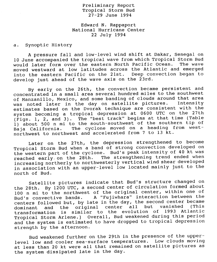
Tropical storm bud
| Tropical storm | |||
|---|---|---|---|
|
|||
| Duration | June 27th - June 29th | ||
| intensity | 40 kn (75 km / h ) (1 minute) , 1003 hPa | ||


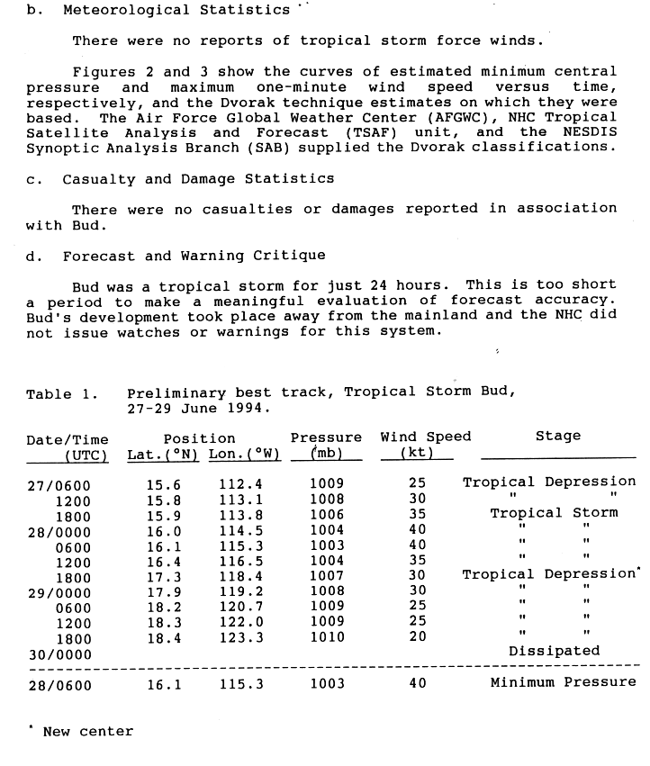
The second tropical low pressure area of the season formed on June 27 about 925 km south-southwest of the southern tip of Lower California . The low pressure area initially moved in a west-northwest direction, but then turned to the northwest and intensified into Tropical Storm Bud. In the morning of the following day, Bud reached his greatest intensity. Wind shear, caused by a nearby low altitude , slowly weakened Bud. A second circulation center was formed late on June 28th . A Fujiwhara effect was noticeable until the second center finally dominated and the first disappeared. This somewhat confused structure of the storm was similar to the development of Tropical Storm Arlene in 1993. It caused Bud to weaken to the tropical depression as the second circulation center formed. Bud eventually migrated westward and disbanded on June 29th. Bud spent the time of his existence entirely over the open ocean, staying far from land. No damage or casualties were reported.
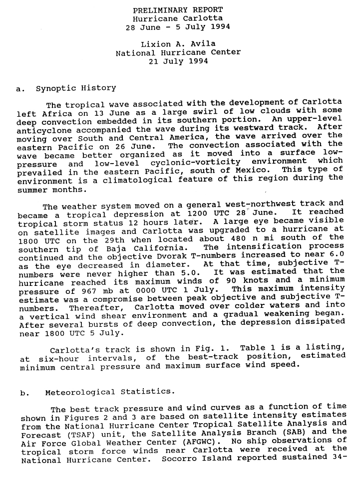
Hurricane Carlotta
| Category 2 hurricane | |||
|---|---|---|---|
|
|||
| Duration | June 28th - July 5th | ||
| intensity | 90 kn (165 km / h ) (1 minute) , 967 hPa | ||


A tropical low pressure area, from which the Tropical Storm Carlotta quickly developed, formed on July 28th. After Carlotta developed an eye , the NHC classified the storm as a hurricane. As such, Carlotta peaked on July 1st with wind speeds of 165 km / h. The hurricane weakened gradually over cooler water and dissolved on July 5th without endangering the mainland.
Carlotta reached sustained winds of 65 km / h on Socorro on June 30th.
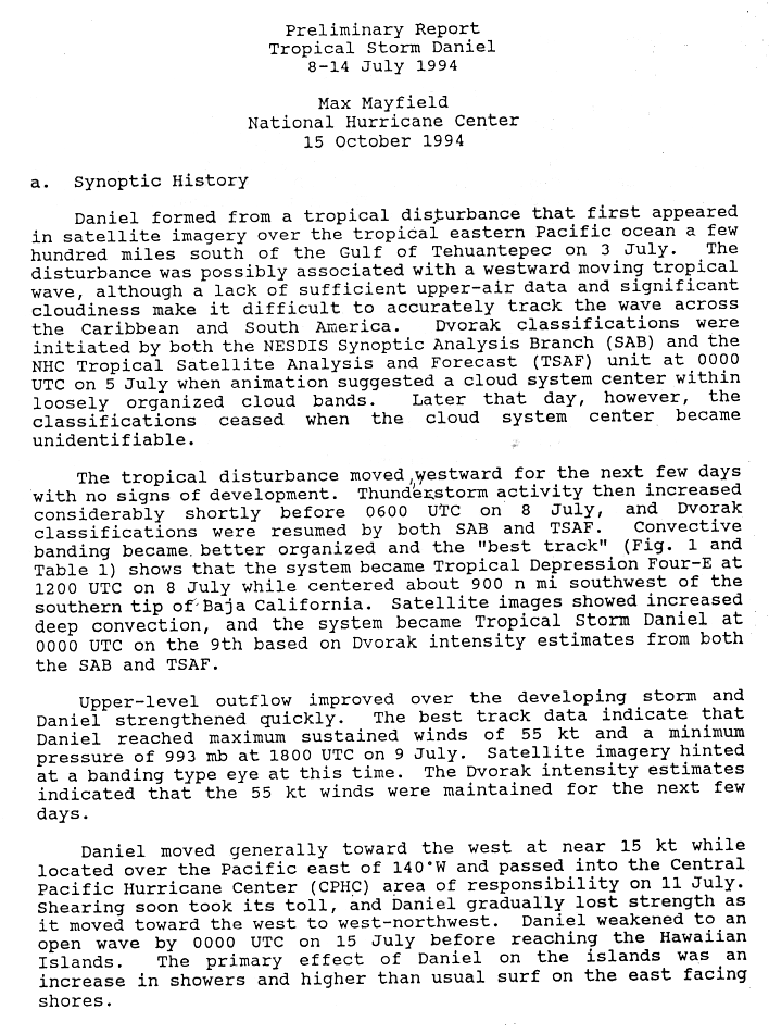
Tropical storm Daniel
| Tropical storm | |||
|---|---|---|---|
|
|||
| Duration | July 8th - July 14th | ||
| intensity | 55 kn (100 km / h ) (1 minute) , 993 hPa | ||
.JPG)

On July 8, a fault developed a circulation about 1,600 km southwest of the southern tip of Lower California and became Tropical Low Pressure Area Vier-E. The atmospheric convection increased and the system intensified into Tropical Storm Daniel. The high discharge improved and Daniel reached his peak intensity on July 9th. This slowly receded as Daniel moved further west. He arrived in the Central Pacific on July 11th. Wind shear weakened Daniel as he approached Hawaii, and by July 15th Daniel had degenerated into an open wave.
As Daniel approached Hawaii, moderate surf hit the south and southeast shores of the Big Island on July 13 and 14. Daniel's remaining low passed about 160 km south of Ka Lae on July 15th . On that day, the remaining low caused rainfall on the windward sides of the island, which locally adds up to 125 mm. However, no harmful effects were reported by Daniel.
Hurricane Emilia
| Category 5 hurricane | |||
|---|---|---|---|
|
|||
| Duration | July 16 - July 25 | ||
| intensity | 140 kn (260 km / h ) (1 minute) , 926 hPa | ||


On July 16, a low pressure area associated with a tropical wave organized itself into the fifth tropical low pressure area in the eastern Pacific Basin. It intensified in the course of the day into Tropical Storm Emilia, which intensified on its west-northwest course towards the hurricane. As such, Emilia entered the Central Pacific on July 17, intensified further, and on July 19 reached Category 5, the first Category 5 hurricane since Ava . Emilia began to ease off rapidly on July 21; Emilia weakened to a tropical storm on July 23 and broke up two days later.
Emilia passed the Hawaiian Islands to the south and caused waves 180–300 cm high on the coasts of Punas and Kaʻūs . The wind caused minor damage and the rain was moderate. People were not killed.
Tropical storm Fabio
| Tropical storm | |||
|---|---|---|---|
|
|||
| Duration | July 19 - July 24 | ||
| intensity | 40 kn (75 km / h ) (1 minute) , 1002 hPa | ||


A tropical depression formed on July 19th. During the course of the day, the system intensified into Tropical Storm Fabio. This moved generally westward or northwestward. It entered the central Pacific Ocean as a tropical depression and dissolved on July 24th.
Fabio's remaining depth caused heavy rainfall in Hawaii , which totaled 75–100 mm, but there was no damage.
Hurricane Gilma
| Category 5 hurricane | |||
|---|---|---|---|
|
|||
| Duration | July 21st - July 31st | ||
| intensity | 140 kn (260 km / h ) (1 minute) , 920 hPa | ||


Part of a tropical wave organized into a tropical depression on July 21st. This migrated westward out to sea and intensified into a tropical storm the next day. Gilma intensified rapidly and became a hurricane after exactly twenty-four hours of existence as a tropical storm. As such, Gilma reached the Central Pacific, where the hurricane continued to intensify, eventually reaching Category 5 on the Saffir-Simpson Hurricane Wind Scale as the second hurricane of the season. For some unknown reason, Gilma suddenly weakened to a tropical storm on July 27th, and three days later to a tropical low, which resolved on July 31st. Hurricane Gilma had less of an impact on Johnston Atoll , where it rained and the winds reached gale force and the waves were high. In connection with Gilma there are no reports of damage or victims.
Hurricane Gilma was the second most intense hurricane in the Pacific Ocean at the time; as of 2008 Gilma is in sixth place. Gilma is the strongest July tower that has formed in the eastern and central Pacific.
Hurricane Li
| Category 1 hurricane | |||
|---|---|---|---|
|
|||
| Duration | July 31st - August 18th | ||
| intensity | 65 kn (120 km / h ) (1 minute) , 1007 hPa | ||
.JPG)

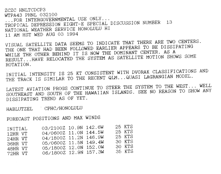
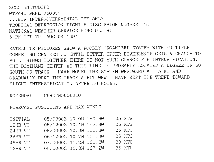
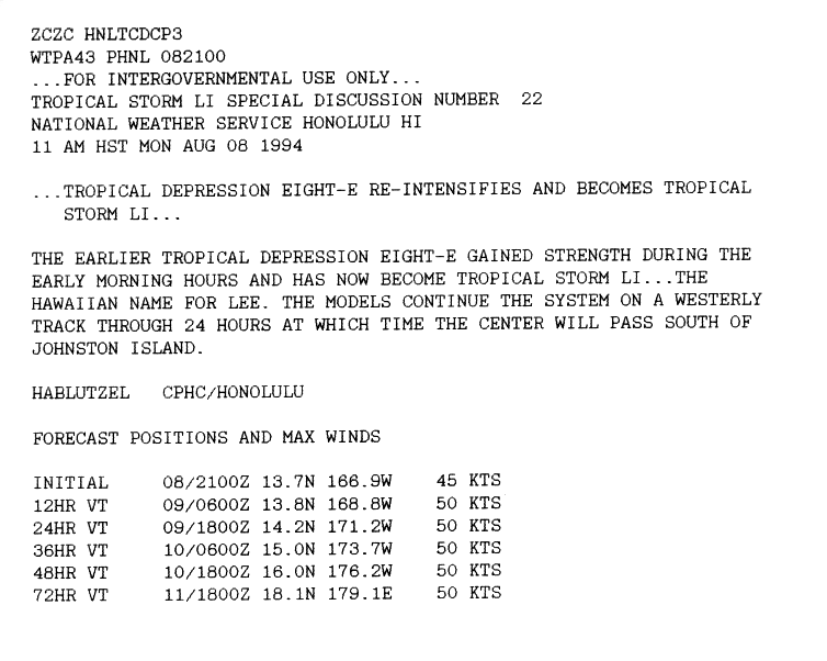
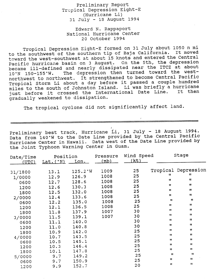
A tropical disturbance south of Cabo San Lucas organized itself into Tropical Depression Eight-E on July 31st. It migrated west-northwest without strengthening significantly before reaching the central Pacific on August 2. Eight-E developed a second circulation center that eventually dominated before the low pressure area was finally captured by the intertropical convergence zone . Eight-E was then disorganized and had multiple circulation centers. The storm warnings were discontinued on August 5th. The remnants of the low pressure area migrated further west, passing Hawaii far to the south. On August 8, the depression was able to regenerate and soon intensified into Tropical Storm Li. Li was approaching the date line on a largely western course. Shortly before reaching the date line, Li intensified into a Category 1 hurricane. It crossed the date line on August 12 and became a typhoon in the western Pacific Ocean . Wind shear through a tropical trough in the upper troposphere caused the weakening and the Joint Typhoon Warning Center downgraded Li to a tropical storm with its first storm warning. Li remained a tropical storm until August 16, then weakened to a low pressure area and resolved after a curve on August 18. On Wake , "o causes shivers, but otherwise had no impact on land. There are no reports of property damage or loss of life caused by Li.
Hurricane Li is one of only six tropical cyclones that existed in all three cyclone basins of the Pacific Ocean. He is one of the three that formed in the Eastern Pacific but were not named until the Central Pacific - the other two are Lala and Iniki . The question of whether Li actually did both is not easy to answer. Although the first observations by the National Hurricane Center were issued for the tropical low pressure area Eight-E, the first data point of Li in the official database has a longitude of 140 ° west longitude, i.e. exactly on the border between the eastern and central Pacific Ocean. However, preliminary data include a number of positions east of this line. Li's status as an East Pacific storm is somewhat controversial in this respect.
Tropical storm Hector
| Tropical storm | |||
|---|---|---|---|
|
|||
| Duration | August 7th - August 10th | ||
| intensity | 55 kn (100 km / h ) (1 minute) , 993 hPa | ||
.JPG)

On August 7th, a tropical wave formed a few hundred kilometers south of Baja California into a tropical depression that quickly developed into Tropical Storm Hector. This moved parallel to the coast of Mexico , weakened and dissolved on August 10th. No damage was reported in connection with Hector.
Originally it was predicted that the storm would approach the Baja California peninsula, which is why storm warnings were issued for the coast on August 8, but these could be lifted during the day. Hector's major impact came in the form of rain. The tropical storm dumped a disjointed zone of heavy rainfall over the coast and inland Mexico. The highest amounts of precipitation were measured with 200; mm at Cerro de Ortega in Ixtlahua and with 193 mm in Caduano, Santiago. However, no damage to property or persons caused by Hector was reported.
Tropical Depression One-C
| Tropical depression | |||
|---|---|---|---|
|
|||
| Duration | August 9th - August 14th | ||
| intensity | 30 kn (55 km / h ) (1 minute) | ||
.JPG)

A weather disturbance organized on August 9 about 1190 km southeast of Hilo to the tropical low pressure area Eins-C. This migrated westward without intensifying and dissolved on August 14th.
The moisture in the system resulted in extensive rainfall over Hawaii that totaled 380mm. Flash floods blocked all major roads in Hilo; these floods have been judged to be the worst in forty years. The rain destroyed two houses and damaged 214, 14 of them badly. Roads and commercial properties were also affected. The damage on the island totaled US $ 5 million (1993). Also on Maui , there was flooding, landslides blocked portions of the Hana Highway. Precipitation from One-C ranks seventh on the list of the wettest tropical cyclones in Hawaii.
Hurricane Ileana
| Category 1 hurricane | |||
|---|---|---|---|
|
|||
| Duration | August 10th - August 14th | ||
| intensity | 65 kn (120 km / h ) (1 minute) , 986 hPa | ||
.JPG)

A disturbance originating in the intertropical convergence zone developed various centers of circulation. After organizing, it broke up and was classified as a Tropical Depression Elf-E on August 10, when the system was about 1,100 miles south-southeast of Baja California Sur . At the time of the second storm observation round, the system was upgraded to Tropical Storm Ileana, at the same time as John, the next storm arose. An eye appeared and on August 12, Ileana became a hurricane. Immediately afterwards, Ileane came across cooler water and was exposed to increasing wind shear. Ileana weakened to a tropical storm on August 13 and was only recognizable the next day as a disintegrating vortex of rain clouds around 840 km west of Punta Eugenia . Although Ileana moved along the coast of Mexico, no specific storm warnings were issued since winds of the strength of a tropical storm were not expected to reach the coast. No damage to persons or property was reported in connection with Ileana.
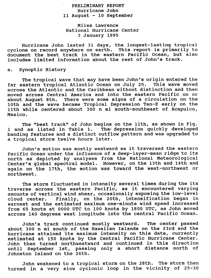
Hurricane john
| Category 5 hurricane | |||
|---|---|---|---|
|
|||
| Duration | August 11th - September 10th | ||
| intensity | 150 kn (280 km / h ) (1 minute) , 929 hPa | ||


- → Main article: Hurricane John (1994)
On August 11th, the Tropical Depression Zehn-E formed south of Mexico. It generally migrated in a westerly direction and was upgraded to Tropical Storm John twelve hours after it was formed. During his further move to the west, John's intensity was changeable, but he was always able to maintain the status of a tropical storm. On August 20, a steady intensification began, and when John got into the Central Pacific, John was a major hurricane. It moved further west and reached Category 5 on August 23rd. It passed Hawaii about 400 km south and passed Johnston Atoll directly north on August 26th . John remained a hurricane until it crossed the dateline on August 28 and became a typhoon of the 1994 typhoon season . After John had weakened to a tropical storm, he took a curve, made a loop, and after another curve, now intensifying, from west to east across the date line, John came back to the central Pacific. Hurricane John moved in a north-northeast direction until it became extratropical on September 10, thirty-one days after its formation.
Before the hurricane hit, 1,100 people were evacuated from Johnston Atoll . The hurricane caused damage amounting to 15 million US dollars (1994) on the atoll. The hurricane did not cause any personal injury; except for the Johnston Atoll, no land areas were affected by John.
Hurricane John was the longest-running tropical cyclone and the cyclone with the longest recorded trajectory that has been observed worldwide since weather records began. It is one of only six tropical cyclones that existed in all three Pacific observation areas. John was also an unusual storm because it crossed the dateline from west to east and because it crossed it multiple times.
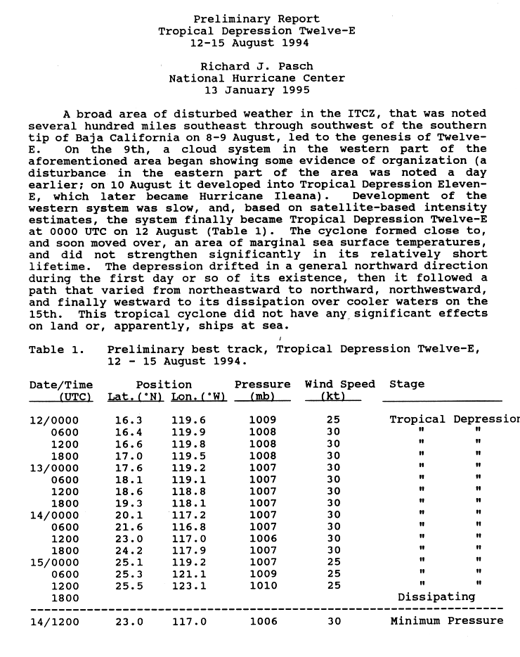
Tropical Depression Twelve-E
| Tropical depression | |||
|---|---|---|---|
|
|||
| Duration | August 12th - August 15th | ||
| intensity | 30 kn (55 km / h ) (1 minute) , 1006 hPa | ||
.JPG)

On August 14th, a convection area had organized itself to such an extent that it was classified as a tropical low pressure area. Controlled by John's extensive circulation , it was not believed that the system would intensify significantly because it was too close to cool surface water. The system drifted along, first northwards, then eastwards, now north again, and finally westwards over the northwest. The National Hurricane Center declared the system disbanded on August 15. The depression had no land impact.
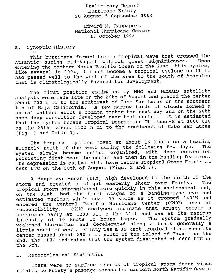
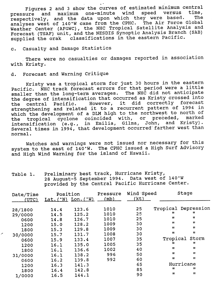
Hurricane Kristy
| Category 2 hurricane | |||
|---|---|---|---|
|
|||
| Duration | August 28th - September 5th | ||
| intensity | 90 kn (165 km / h ) (1 minute) , ≤992 hPa | ||
.JPG)

On August 28, the Tropical Depression Thirteen-E formed about 2,100 km southwest of the tip of Baja California. It became Tropical Storm Kristy on August 30th. When Kristy got to the Central Pacific, one eye formed and Kristy intensified into the hurricane, which twelve hours later was Category 2, which is its greatest intensity. Kristy continuously weakened from then on due to wind shear. The system passed Hawaii about 480 km south and disintegrated on September 5th. The lowest central air pressure of Kristy is unknown, the last determination was made under the responsibility of NHC Miami when Kristy was still a tropical storm in the eastern Pacific.
As the storm neared the Hawaiian Islands, warnings of high winds and high waves were raised for the Big Island , but storm-related damage or casualties were not detected.
Hurricane Lane
| Category 4 hurricane | |||
|---|---|---|---|
|
|||
| Duration | September 3 - September 10 | ||
| intensity | 115 kn (215 km / h ) (1 minute) , 948 hPa | ||
.JPG)

The same tropical wave that had produced Tropical Depression Five in the Atlantic became Tropical Depression Fourteen-E on September 3rd. It rapidly intensified into Tropical Storm Lane. A high pressure ridge centered north of Lane urged it on a westerly course. This put Lane in very favorable conditions for its development and Lane intensified. When the storm reached hurricane strength, a phase of rapid intensification began, making it a Category 4 hurricane with winds of 215 km / h. The high pressure ridge pulled east, clearing the way for Lane. Lane reached unfavorable conditions because of this and weakened until he broke up on September 10th.
Tropical storm Mele
| Tropical storm | |||
|---|---|---|---|
|
|||
| Duration | September 6th - September 9th | ||
| intensity | 35 kn (65 km / h ) (1 minute) | ||
.JPG)

A tropical fault became Tropical Depression Two-C on September 6th. The next day it reached the strength of a tropical storm and was named Mele . This name means song in the Hawaiian language and it is also the Hawaiian form of the English female name Mary . Mele migrated in a west-northwest direction, but weakened to a tropical low on September 9 and dissolved during the day without incident due to the storm.
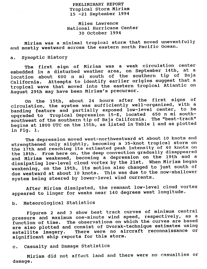
Tropical storm Miriam
| Tropical storm | |||
|---|---|---|---|
|
|||
| Duration | September 15 - September 21 | ||
| intensity | 40 kn (75 km / h ) (1 minute) , 1002 hPa | ||
.JPG)

Miriam formed on September 15th from a mild disorder. This intensified to the light tropical storm Miriam, which dissolved without further development and without any effects on September 21st. However, after the system dissolved near 140 ° W, the remains of Miriam were still visible for several weeks.
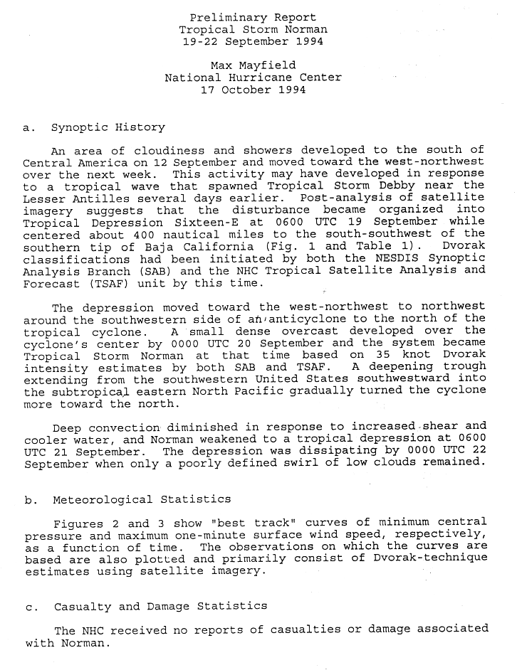
Tropical storm Norman
| Tropical storm | |||
|---|---|---|---|
|
|||
| Duration | September 19 - September 22 | ||
| intensity | 35 kn (65 km / h ) (1 minute) , 1004 hPa | ||
.JPG)

A tropical depression formed on September 19, which intensified the next day into Tropical Storm Norman. Originally migrating west, the system began to change course to the north because of a trough and the convection began to subside. Norman disbanded on September 22nd without having had land impact.
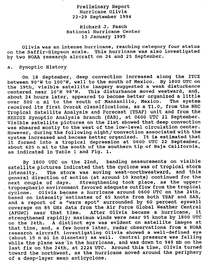
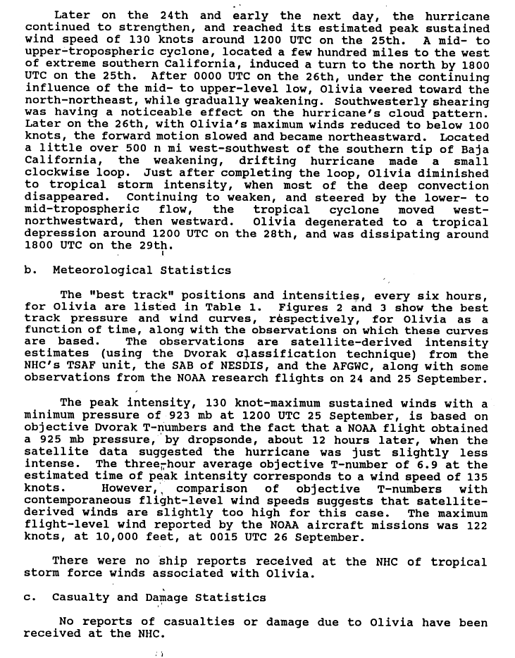
Hurricane Olivia
| Category 4 hurricane | |||
|---|---|---|---|
|
|||
| Duration | September 22nd - September 29th | ||
| intensity | 130 kn (240 km / h ) (1 minute) , 923 hPa | ||


Hurricane Olivia arose from a disturbance that broke away from the intra-tropical convergence zone on September 19. The fault moved slowly westward and organized itself into the tropical depression on September 22, about 1,160 km south of Cabo San Lucas . The depression moved west-northwest and intensified into a tropical storm on September 22nd. This intensified steadily and turned into a hurricane on September 24th. Hurricane Rosa intensified rapidly into a major hurricane that made a curl-like movement towards the northwest. Olivia reached the greatest intensity on September 25 with a central air pressure of 923 hPa. In the meantime, a large cyclone had formed off the extreme south of California , which was taking a northward path. So Olivia started a small anti-cyclonic loop that resulted in the wind shear weakening of the hurricane. By the time Olivia completed the loop, the hurricane had weakened into a tropical storm. As such, it moved westward and weakened to tropical depression on September 28; Olivia broke up the next day. The hurricane had no reported land impact.
At the time, Hurricane Olivia was the third strongest hurricane in the Pacific Ocean and the second strongest in the Eastern Pacific Basin. Since then, a few more hurricanes have reached lower air pressure in their core, Olivia is currently the ninth strongest Pacific hurricane and the seventh strongest in the Eastern Pacific Ocean. Olivia was also the strongest hurricane in September at the time. That record was later broken by Hurricane Linda . Olivia is the strongest Pacific hurricane that was not classified in Category 5 on the Saffir-Simpson Hurricane Wind Scale. Hurricane Juliette reached exactly the same central air pressure in 2001 and is therefore ranked in the same place.
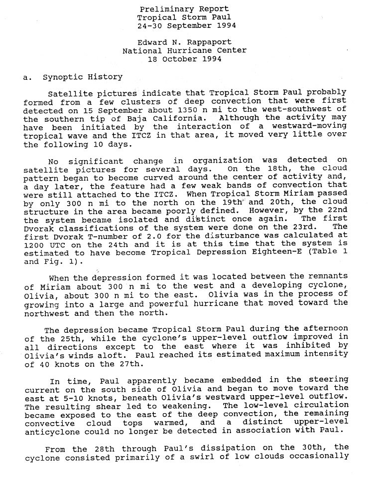
Tropical storm Paul
| Tropical storm | |||
|---|---|---|---|
|
|||
| Duration | September 24th - September 30th | ||
| intensity | 40 kn (75 km / h ) (1 minute) , 1003 hPa | ||
.JPG)

A near-stationary area with thunderstorms and atmospheric convection has been hanging around since September 15, avoiding destruction by Tropical Storm Miriam. It evolved into Tropical Depression Eighteen-E on September 24th. The system was located between the residual low Miriams and the developing Hurricane Olivia. It turned into Tropical Storm Paul on the afternoon of September 25th, which reached its peak two days later on September 27th. Then Olivia's discharge began to shear Paul on high . On September 30th the wind shear completely destroyed Paul. The tropical storm did not threaten any land area and as a result no damage to property or loss of life was reported.
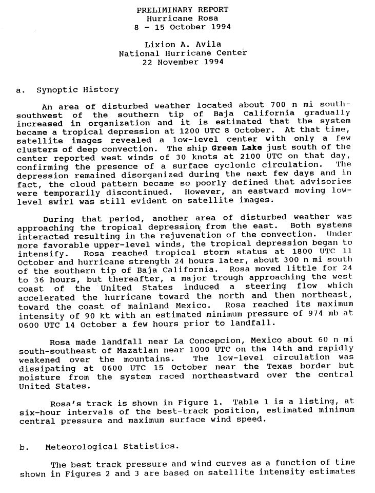
Hurricane pink
| Category 2 hurricane | |||
|---|---|---|---|
|
|||
| Duration | October 8th - October 15th | ||
| intensity | 90 kn (165 km / h ) (1 minute) , 974 hPa | ||


- → Main article: Hurricane Pink
An area with a weather disturbance organized itself into a tropical depression at noon on October 8th. The system was having difficulty organizing itself and the storm warnings were temporarily suspended. The cyclone finally became a tropical storm on October 11th and was named Rosa . Rosa walked very slowly until a trough finally steered the storm north and later northeast. Rosa quickly intensified to her greatest strength in Category 2 on the Saffir-Simpson Hurricane Wind Scale, just before landfall on the morning of October 14th near La Concepción on the Mexican coast. Pink was rapidly disintegrating over the Mexican mountains, and the remaining cloudfield quickly moved northward over the United States, spreading its moisture.
Four deaths, two each in the states of Nayarit and Durango , have been reported. Four more were missing in Sinaloa . Those killed have all drowned . More than 10,000 residents of Nayarit were affected by the storm because their apartments and houses were damaged or destroyed. Telephone poles and the power grid were torn down in Sinaloa. The rain from the hurricane caused landslides and flash floods in the mountainous regions . As a result , 400 residents of two coastal villages in Jalisco had to be evacuated. The highest amount of precipitation was measured at 358 mm in Mesa de Pedro Pablo. The moisture that rose to the United States contributed to the record rainfall in southeast Texas between October 15 and 19. This heavy rain event triggered floods that killed 22 people and destroyed more than 3,000 houses. The property damage as a result amounted to about 700 million US dollars.
Tropical storm Nona
| Tropical storm | |||
|---|---|---|---|
|
|||
| Duration | October 21st - October 26th | ||
| intensity | 35 kn (65 km / h ) (1 minute) | ||
.JPG)

Tropical Depression Drei-C formed in the Central Pacific on October 21. It moved west for about four days before intensifying into a tropical storm on October 25th. The CPHC assigned the name "Nona". Nona immediately weakened back to the low pressure area. High westerly winds destroyed the system on October 26th. Nona did not result in any loss of property or life. Nona was classified as a tropical storm for only six hours, the shortest possible time.
Season course

The season began with the formation of Tropical Depression Eins-E a on June 18th and ended with the dissolution of Nona on October 26th. No named storm formed in May, three formed in June, four in July, five in August, six in September, and two in October. No named storm formed in November. Overall, the 1994 Pacific hurricane season lasted 130 days from the formation of the first to the dissolution of the last.
Accumulated Cyclone Energy (ACE)
| Accumulated Cyclone Energy | |||||
|---|---|---|---|---|---|
| rank | Surname | ACE | rank | Surname | ACE |
| 1 | John | 10.1 (43.9) | 11 | Ileana | 3.16 |
| 2 | Emilia | 1.72 (31.4) | 12 | Hector | 1.65 |
| 3 | Gilma | 5.80 (18.8) | 13 | Aletta | 1.42 |
| 4th | Olivia | 16.5 | 14th | Miriam | 1.30 |
| 5 | Lane | 12.7 | 15th | Paul | 1.22 |
| 6th | Carlotta | 10.5 | 16 | Mele | (0.980) |
| 7th | pink | 6.21 | 17th | Fabio | 0.65 |
| 8th | Kristy | 1.02 (5.16) | 18th | Norman | 0.613 |
| 9 | Daniel | 2.91 (2.22) | 19th | Bud | 0.565 |
| 10 | Li | (4.48) | 20th | Nona | (0.123) |
| Total: 78.0 (107) | |||||
The Accumulated Cyclone Energy (ACE) is a measure with which the activity of a hurricane season can be compared. It is calculated by squaring the wind speed of a tropical cyclone determined every six hours. This number is accumulated and finally divided by 10 4 . Only tropical cyclones that reached at least the wind speed of a tropical storm are taken into account. The measure is given to three significant places. For the eastern Pacific, only the storm warnings that were issued when the storm center was between 140 degrees west longitude and the American mainland are used; the ACE values for the Central Pacific (between the date line and 140 ° west longitude) are given in parentheses. The table does not include the ACE for Li and John when they were west of the dateline, as these values belong to the 1994 typhoon season .
The National Hurricane Center uses the cumulative ACE of all tropical storms to assess whether the hurricane season was below average, almost normal or above average, and the number of storms. According to the NHC, a hurricane in the Pacific Ocean is considered to be below average if the ACE is lower than 95 × 10 4 kn 2 ; An ACE sum of more than 150 × 10 4 kn 2 and at least two of the following three values are exceeded: 15 tropical storms, 9 hurricanes, 4 severe hurricanes are considered to be above average . A hurricane season with an ACE sum between 100 and 150 × 10 4 kn 2 or, if the ACE is higher than 150 × 10 4 kn 2 , if at most one value of the average number of storms is exceeded is considered almost normal .
Seventeen tropical storms occurred in the eastern and central Pacific Oceans in 1994, nine of which developed into hurricanes, including five major hurricanes. The season's ACE is 185 10 4 kn 2 . So this season was above average.
Storm names
The following names were used for storms that formed in the eastern and central Pacific Oceans in 1994; unused names are marked in gray . None of these names were removed from the list of tropical cyclone names after the season, so the list was used again unchanged in the 2000 Pacific hurricane season . The list is almost identical to the one used during the 1988 Pacific hurricane season - only Ileana replaced Iva.
|
|
In addition, three storm names from the list were used for the central Pacific - Li, Mele, and Nona. All three were used for the first time.
Web links
- NHC archive to the Pacific hurricane season 1994 (English)
- Report on hurricane season 1994 of the Central Pacific Hurricane Center (English)
Individual evidence
- ↑ a b c d e f g h i j k l m n o p q National Hurricane Center: Eastern Pacific hurricane best track analysis 1949-2014 ( English ) United States National Oceanic and Atmospheric Administration's Office of Oceanic & Atmospheric Research. October 15, 2015. Retrieved October 25, 2015.
- ↑ a b c Background Information: East Pacific Hurricane Season . Climate Prediction Center . May 22, 2008. Retrieved September 23, 2008.
- ↑ a b Previous Tropical Systems in the Central Pacific ( English ) Central Pacific Hurricane Center . Retrieved December 12, 2008.
- ↑ Andy Nash, Tim Craig, Sam Houston, Roy Matsuda, Jeff Powell, Ray Tanabe, & Jim Weyman: 2006 Tropical Cyclones Central North Pacific ( English ) Central Pacific Hurricane Center . July 2007. Retrieved December 12, 2008.
- ↑ a b Benjamin Hablutzel, Hans Rosendal, James Weyman, & Jonathan Hoag: The 1997 Central Pacific Tropical Cyclone Season ( English ) Central Pacific Hurricane Center. Retrieved December 12, 2008.
- ↑ a b Lixion Avila: Preliminary Report Hurricane Rosa (GIF) National Hurricane Center . S. 2. November 22, 1994. Retrieved December 12, 2008.
- ↑ a b c d e f g h i j k l m n o p q r s t u v w The 1994 Central Pacific Tropical Cyclone Season ( English ) Central Pacific Hurricane Center. Retrieved December 12, 2008.
- ↑ a b Gary Padgett: Monthly Global Tropical Cyclone Summary April 2004 ( English ) Archived from the original on September 30, 2007. Information: The archive link was automatically inserted and not yet checked. Please check the original and archive link according to the instructions and then remove this notice. Retrieved December 12, 2008.
- ^ NOAA: 2008 Eastern Pacific Hurricane Season Outlook . Climate Prediction Center. May 22, 2008. Retrieved December 12, 2008.
- ^ Historical East Pacific Seasonal Activity ( English , GIF) Climate Prediction Center. Retrieved December 12, 2008.
- ^ A b Neal Dorst: Subject: E6) Which tropical cyclone lasted the longest? ( English ) In: FAQ: Hurricanes, Typhoons, and Tropical Cyclones . Atlantic Oceanographic and Meteorological Laboratory . Retrieved December 8, 2008.
- ^ Richard Pasch: Preliminary Report Tropical Storm Aletta ( English , GIF) National Hurricane Center. S. 1. October 25, 1994. Retrieved December 12, 2008.
- ^ Richard Pasch: Preliminary Report Tropical Storm Aletta ( English , GIF) National Hurricane Center. S. 2. October 25, 1994. Retrieved December 12, 2008.
- ^ Edward Rappaport: Preliminary Report Tropical Storm Bud ( English , GIF) National Hurricane Center. S. 1. July 22, 1994. Retrieved December 12, 2008.
- ^ Edward Rappaport: Preliminary Report Tropical Storm Bud ( English , GIF) National Hurricane Center. S. 2. July 22, 1994. Retrieved December 12, 2008.
- ↑ a b Lixion Avila: Preliminary Report Hurricane Carlotta ( English , GIF) National Hurricane Center. S. 1. July 21, 1994. Retrieved December 12, 2008.
- ↑ a b Lixion Avila: Preliminary Report Hurricane Carlotta ( English , GIF) National Hurricane Center. S. 2. July 21, 1994. Retrieved December 12, 2008.
- ↑ Max Mayfield: Preliminary Report Tropical Storm Daniel ( English , GIF) National Hurricane Center. S. October 14, 1994. Retrieved December 12, 2008.
- ↑ Max Mayfield: Preliminary Report Tropical Storm Daniel ( English , GIF) National Hurricane Center. S. 2. October 14, 1994. Retrieved December 12, 2008.
- ↑ Miles Lawrence: Preliminary Report Hurricane Emilia ( English , GIF) National Hurricane Center. S. 1. August 13, 1994. Retrieved December 12, 2008.
- ↑ Miles Lawrence: Preliminary Report Hurricane Emilia ( English , GIF) National Hurricane Center. S. 2. August 13, 1994. Retrieved December 12, 2008.
- ^ Max Mayfield: Preliminary Report Tropical Storm Fabio ( English , GIF) National Hurricane Center. S. 1. October 15, 1994. Retrieved December 8, 2008.
- ^ Max Mayfield: Preliminary Report Tropical Storm Fabio ( English , GIF) National Hurricane Center. S. 2. October 15, 1994. Retrieved December 8, 2008.
- ^ Richard J. Pasch: Preliminary Report Hurricane Gilma ( English , GIF) National Hurricane Center. S. 1. January 20, 1995. Retrieved December 12, 2008.
- ^ A b Richard J. Pasch: Preliminary Report Hurricane Gilma (GIF) National Hurricane Center. S. 2. January 20, 1995. Retrieved December 12, 2008.
- ↑ a b Pasch: Tropical Depression Eight-E Discussion 1 ( English ) National Hurricane Center. July 31, 1994. Retrieved December 12, 2008.
- ^ Rappaport: Tropical Depression Eight-E Discussion Number 10 ( English ) National Hurricane Center. August 2, 1994. Retrieved December 12, 2008.
- ↑ Hablutzel: Tropical Depression Eight Special Discussion Number 13 (GIF) National Hurricane Center. August 3, 1994. Retrieved December 12, 2008.
- ^ Farrell: Tropical Depression Eight E Discussion 16 (GIF) National Hurricane Center. August 4, 1994. Retrieved September 24, 2008.
- ^ Rosendal: Tropical Depression Eight-E Discussion 18 (GIF) National Hurricane Center. August 4, 1994. Retrieved September 24, 2008.
- ↑ Hablutzel: Tropical Storm Li Special Discussion Number 22 ( English , GIF) National Hurricane Center. August 8, 1994. Retrieved December 12, 2008.
- ↑ Typhoon Li (08E) (PDF) In: 1994 Annual Tropical Cyclone Report . Joint Typhoon Warning Center . Pp. 105-106. Retrieved on September 24, 2008. ( Page no longer available , search in web archives ) Info: The link was automatically marked as defective. Please check the link according to the instructions and then remove this notice.
- ^ Edward Rappaport: Preliminary Report Tropical Depression Eight-E (Hurricane Li) ( English , GIF) National Hurricane Center. October 20, 1994. Retrieved December 12, 2008.
- ^ Lixion Avila: Preliminary Report Tropical Storm Hector ( English , GIF) National Hurricane Center. S. 1. September 20, 1994. Retrieved December 12, 2008.
- ↑ a b Lixion Avila: Preliminary Report Tropical Storm Hector ( English , GIF) National Hurricane Center. S. 2. September 20, 1994. Retrieved December 12, 2008.
- ^ David M. Roth: Tropical Storm Hector ( English ) Hydrometeorological Prediction Center . Archived from the original on October 19, 2008. Info: The archive link was inserted automatically and has not yet been checked. Please check the original and archive link according to the instructions and then remove this notice. Retrieved December 12, 2008.
- ↑ Flood Report: Kauai Mountains ( English ) National Climatic Data Center . Archived from the original on May 19, 2011. Retrieved December 12, 2008.
- ↑ Flood Report: Kauai Leeward ( English ) National Climatic Data Center . Archived from the original on July 21, 2011. Retrieved December 12, 2008.
- ^ A b Max Mayfield: Preliminary Report Hurricane Ileana ( English , GIF) National Hurricane Center . S. 1. October 17, 1994. Retrieved December 12, 2008.
- ^ Rappaport: Tropical Storm Ileana Discussion Number 2 ( English ) National Hurricane Center. August 11, 1994. Retrieved December 12, 2008.
- ^ Rappaport: Tropical Storm John Discussion Number 3 ( English ) National Hurricane Center. August 11, 1994. Retrieved December 12, 2008.
- ^ Max Mayfield: Preliminary Report Hurricane Ileana ( English , GIF) National Hurricane Center. S. 2. October 17, 1994. Retrieved December 12, 2008.
- ^ Miles Lawrence: Preliminary Report Hurricane John ( English , GIF) National Hurricane Center. January 3, 1995. Retrieved December 12, 2008.
- ^ Typhoon John (10-E) ( English , PDF) Joint Typhoon Warning Center . 128. Archived from the original on March 18, 2009. Retrieved December 12, 2008.
- ↑ Mayfield: Tropical Depression Twelve-E Discussion Number 1 ( English ) National Hurricane Center. August 14, 1994. Retrieved December 12, 2008.
- ^ A b Richard Pasch: Preliminary Report Tropical Depression Twelve-E (GIF) National Hurricane Center. January 13, 1995. Retrieved December 12, 2008.
- ↑ Mayfield: Tropical Depression Twelve-E Discussion Number 5 ( English ) National Hurricane Center. August 15, 1994. Retrieved December 12, 2008.
- ↑ Edward Rappaport: Preliminary Report Hurricane Kristy ( English , GIG) p. October 1, 1994. Retrieved September 25, 2008.
- ^ Edward Rappaport: Preliminary Report Hurricane Kristy (GIG) pp. October 2, 17, 1994. Retrieved December 12, 2008.
- ^ National Hurricane Center. Hurricane Lane. Retrieved December 12, 2008.
- ↑ Behind the Name: Meaning, Origin and History of the name Mele ( English ) Behind the Name: The Etymology and History of First Names. Retrieved December 12, 2008.
- ^ Miles Lawrence: Preliminary Report Tropical Storm Miriam ( English , GIF) National Hurricane Center. S. 1. October 30, 1994. Retrieved November 26, 2008.
- ^ Max Mayfield: Preliminary Report Tropical Storm Norman ( English , GIF) National Hurricane Center. S. October 17, 1997. Retrieved November 23, 2008.
- ^ Richard Pasch: Preliminary Report Hurricane Olivia ( English , GIF) National Hurricane Center. S. 1. Retrieved September 26, 2008.
- ^ Richard Pasch: Preliminary Report Hurricane Olivia ( English , GIF) National Hurricane Center. P. 2. Retrieved September 26, 2008.
- ^ Edward Rappaport: Preliminary Report Tropical Storm Paul ( English , GIF) National Hurricane Center. S. 1. October 18, 1994. Retrieved December 12, 2008.
- ^ Edward Rappaport: Preliminary Report Tropical Storm Paul ( English , GIF) National Hurricane Center. S. 2. October 18, 1994. Retrieved December 12, 2008.
- ^ Lixion Avila: Preliminary Report Hurricane Rosa ( English , GIF) National Hurricane Center. S. 1. November 22, 1994. Retrieved December 12, 2008.
- ^ Mexican West Coast Survives Hurricane , Chicago Daily Herald . October 15, 1994, p. 3. Archived from the original on December 25, 2015 Info: The archive link was automatically inserted and not yet checked. Please check the original and archive link according to the instructions and then remove this notice. . Retrieved December 12, 2008.
- ↑ David M. Roth: Hurricane Rosa ( English , GIF) Hydrometeorological Prediction Center. Archived from the original on October 19, 2008. Info: The archive link was inserted automatically and has not yet been checked. Please check the original and archive link according to the instructions and then remove this notice. Retrieved December 12, 2008.
- ↑ Floods in Southeast Texas, October 1994 ( English , PDF; 565 kB) United States Geological Survey . January 1995. Retrieved December 12, 2008.
- ↑ Original HURDAT format . Atlantic Oceanographic and Meteorological Laboratory Hurricane Research Division. Retrieved October 2, 2008.

1960 | 1961 | 1962 | 1963 | 1964 | 1965 | 1966 | 1967 | 1968 | 1969 | 1970 | 1971 | 1972 | 1973 | 1974 | 1975 | 1976 | 1977 | 1978 | 1979 | 1980 | 1981 | 1982 | 1983 | 1984 | 1985 | 1986 | 1987 | 1988 | 1989 | 1990 | 1991 | 1992 | 1993 | 1994 | 1995 | 1996 | 1997 | 1998 | 1999 | 2000 | 2001 | 2002 | 2003 | 2004 | 2005 | 2006 | 2007 | 2008 | 2009 | 2010 | 2011 | 2012 | 2013 | 2014 | 2015 | 2016 | 2017 | 2018 | 2019 | 2020 | 2021