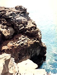
Ka Lae
| South Point Complex | ||
|---|---|---|
| National Register of Historic Places | ||
| Historic District | ||
| National Historic Landmark | ||
|
Rock cliff at Ka Lae |
||
|
|
||
| location | west of Nāʻālehu , Hawaii County , Hawaii | |
| Coordinates | 18 ° 54 '36 " N , 155 ° 40' 52" W | |
| NRHP number | 66000291 | |
| The NRHP added | October 15, 1966 | |
| Declared as an NHL | December 29, 1962 | |
Ka Lae ( Hawaiian for "the tip"), also known as South Point (southern tip) is the southernmost headland of the Big Island in the state of Hawaii . It is also the southernmost point of the 50 states of the United States of America . It is located in the traditional ahapuaʻa Kamaoa in the Kaʻū district .
history
Ka Lae is very likely the site of the oldest Polynesian settlement on the Hawai'i archipelago, as it is closest to the likely place of origin of this ethnic group - the Marquesas or Society Islands . Remains of a heiau and other religious buildings were found, which archaeologists at the Bishop Museum in Honolulu dated to 124. In addition, numerous boreholes were found in the area of the cliffs , which were probably used to secure fishing boats drifting in the current. The area of the National Historic Landmark District known as the South Point Complex - which the area was declared on December 29, 1962 - is home to numerous Polynesian burial sites. On October 15, 1966, Ka Lae was added to the National Register of Historic Places as a Historic District .
Natural space
The convergence of different currents ensures a species-rich and extensive marine fauna, especially the occurrences of the ulua belonging to the jackfish and the Pacific redfish . Hawaiian turtles are often found in the area of the cliffs, some of which use the nearby beaches to lay eggs, and Hawaiian monk seals occasionally use the rocks for sunbathing.
Since the steadily strong blowing wind prevents larger plants from settling on land, the flora is characterized by extensive grassy areas, larger land animals do not occur.
The currents of the Pacific garbage vortex and the inaccessibility of the cliffs also mean that this stretch of coast is one of the most polluted in the entire USA.
Access
Ka Lae can be reached from Hawai'i State Route 11 via the paved South Point Road, approximately 30 kilometers . To do this, leave the main road about 11 kilometers west of the village of Nāʻālehu . Near the Pu'u Nanaia there is a lookout point on the highway that offers a view of the cape and the nearby wind farm.
About one kilometer east of the cape, the Kaulana Ramp offers access from the sea.
Web links
- Hawaii Visitors and Convention Bureau website
- Ka Lae in the Geographic Names Information System of the United States Geological Survey
Individual evidence
- ↑ cf. Ka Lae in Place Names of Hawaii
- ↑ [1]
- ↑ Listing of National Historic Landmarks by State: Hawaii. National Park Service , accessed July 22, 2019.
- ^ South Point Complex on the National Register Information System. National Park Service , accessed August 8, 2017.


