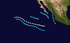
1964 Pacific hurricane season
 All the storms of the season | |
| Formation of the first storm |
July 6, 1964 |
|---|---|
| Dissolution of the last storm |
September 9, 1964 |
| Strongest storm | Odessa - Unknown hPa ( mbar ), 75 kn (140 km / h ) |
| Tropical lows | 5 |
| Storms | 5 |
| Hurricanes | 1 |
| Severe hurricanes ( Cat. 3+ ) | 0 |
| Total number of victims | Unknown |
| Total damage | Unknown |
|
Pacific hurricane season 1962 , 1963 , 1964 , 1965 , 1966 | |
The 1965 Pacific hurricane season officially began on May 15, 1965 in the Eastern Pacific Ocean and June 1, 1965 in the Central Pacific. It lasted until November 30, 1965. That hurricane season was the least active hurricane season on record. During this season only five tropical storms formed and only one intensified into a hurricane . The first storm of the season, Tropical Storm Natalie, hit the countryside in Mexico . About a week later, Hurricane Odessa became the strongest storm of the season.
Storms
Tropical storm Natalie
| Tropical storm | |||
|---|---|---|---|
|
|||
| Duration | July 6th - July 7th | ||
| intensity | 45 kn (85 km / h ) (1 minute) | ||
The first tropical storm developed just off the coast of Mexico on July 6th. Natalie wandered north without strengthening. Shortly before his transition the next day, Natalie developed into an extra-tropical cyclone. The rest lasted until July 8th.
Hurricane Odessa
| Category 1 hurricane | |||
|---|---|---|---|
|
|||
| Duration | July 15 - July 19 | ||
| intensity | 75 kn (140 km / h ) (1 minute) | ||
Hurricane Odessa formed on July 15th. Initially, the hurricane moved west-northwest, but on July 18, it turned north-west, and shortly thereafter west-southwest. In the meantime, Odessa kept the hurricane intensity for several days in order to disperse on July 19 at 18:00 UTC.
Tropical storm Prudence
| Tropical storm | |||
|---|---|---|---|
|
|||
| Duration | Jul 20 - July 24 | ||
| intensity | 45 kn (85 km / h ) (1 minute) | ||
Prudence developed on July 20th. It was moving west-northwest and failed to intensify. After a short turn to the west on July 22nd, it returned to a west-northwest direction. Shortly before disbanding on July 24th, the system turned back west. Although it never moved across the country, the cyclone produced high waves along the California coast, with the highest waves in Newport Beach .
Tropical storm Roslyn
| Tropical storm | |||
|---|---|---|---|
|
|||
| Duration | August 21 - August 22 | ||
| intensity | 45 kn (85 km / h ) (1 minute) | ||
Tropical Storm Roslyn formed around 800 km south-southwest of Cabo San Lucas on August 21 . Roslyn was drifting west-northwest with the same intensity as the previous system. The storm subsided at 6:00 p.m. UTC on August 22nd.
Tropical storm Tillie
| Tropical storm | |||
|---|---|---|---|
|
|||
| Duration | September 7th - September 9th | ||
| intensity | 45 kn (85 km / h ) (1 minute) | ||
The last tropical cyclone of the season, Tropical Storm Tillie, developed on July 7th. Initially the cyclone moved north-northwest, but on September 8, about 160 km southwest of Cabo San Lucas, the storm moved west-northwest. The storm was active for less than 48 hours, Tille dismantled on September 9 at 6:00 a.m. UTC. Although the storm remained at sea, residual moisture was over southern Arizona advected so that a passing cold front triggered the evening of September 9 widespread showers and thunderstorms. In Tusco, precipitation fell 77mm between September 9th and 10th. At two other locations, one in the Santa Catalina Mountains and the other near Sahuarita , 171 mm of precipitation was measured.
Season summary
With just five named storms, the season was well below the 13 storm average. In fact, with only five named storms, this is the lowest number of storms in the hurricane database. Only one tropical cyclone achieved hurricane status, compared to the average of seven per year. 1964 is also one of the few seasons without a major hurricane. However, it is possible that some storms were missed due to the lack of satellite coverage in the area.

Storm names
The following names were used for named storms that formed in the East Pacific in 1964. No names were removed from this list after the season. This is part of List 2 that was in use from 1960-1965. Names that have not been assigned are marked in gray .
|
|
|
See also
Web links
Individual evidence
- ↑ a b c d e National Hurricane Center: Eastern Pacific hurricane best track analysis 1949-2014 ( English ) United States National Oceanic and Atmospheric Administration's Office of Oceanic & Atmospheric Research. October 15, 2015. Retrieved October 25, 2015.
- ↑ Towering surf hits California . In: Tri-City Herald , July 21, 1964. Retrieved October 29, 2011.
- ^ Coastal Services Center: Historical Hurricane Tracks . National Oceanic and Atmospheric Administration . Archived from the original on April 10, 2006. Info: The archive link was inserted automatically and has not yet been checked. Please check the original and archive link according to the instructions and then remove this notice. Retrieved October 29, 2011.
- ↑ United States Army Corps of Engineers : Santa Cruz River, Paseo de las Iglesias (Pima County, Arizona) Final Feasibility Report and Environmental Impact Statement (PDF; 5.0 MB) Retrieved July 21, 2011.
- ^ Raymond, A. Green: The Weather and Circulation of September 1964 . In: Monthly Weather Review . 92, No. 12, December 1964, pp. 601-606. bibcode : 1964MWRv ... 92..601G . doi : 10.1175 / 1520-0493 (1964) 092 <0601: TWACOS> 2.3.CO; 2 .


