Hvítá (Borgarfjörður)
| Hvítá | ||
|
Hvítá above the Hraunfossar |
||
| Data | ||
| location | Iceland | |
| River system | Hvítá | |
| Drain over | Borgarfjörður → Atlantic | |
| source | in the Hvítárdrög between Eiríksjökull and Strútur | |
| muzzle |
Borgarfjörður coordinates: 64 ° 34 ′ 0 ″ N , 21 ° 46 ′ 0 ″ W 64 ° 34 ′ 0 ″ N , 21 ° 46 ′ 0 ″ W.
|
|
| length | 117 km | |
| Catchment area | 1.685 km² | |
| Left tributaries | Geitá , Reykjadalsá , Flókadalsá , Grímsá | |
| Right tributaries | Norðlingafljót , Norðurá , Þverá | |
| Communities | Borgarbyggð | |
| Waterfalls: Hraunfossar , Barnafoss | ||
|
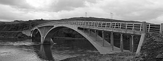
Bridge at Ferjukot , built in 1928 |
||
Hvítá is a river in West Iceland , near the Reykholtsdalur . The river is located in the municipality of Borgarbyggð .
Most important dates
The collecting river Hvítá, which absorbs the water from both spring and glacier rivers, has a length of 117 km, the highest measured amount of water was 500 m³ / s. Average amounts in summer are 60–100 m³ / s, in winter 70– 90 m³ / s. The catchment area covers 1685 km².
course
The Hvítá rises in the Hallmundarhraun lava field , more precisely in the so-called Hvítárdrög between Eiríksjökull and Strútur . This lava field was formed by the eruption of craters on the northern edge of the Langjökull glacier about 1100 years ago.
The river initially flows to the northwest, only to turn to the west after a few kilometers and from now on mostly maintain this main direction. It flows past Kalmanstunga, turns slightly south and then west again to flow at the foot of Mount Tunga northeast of Húsafell . Not far from the driveway to the Kaldidalur highland piste , still above Húsafell, the tributary Geitá, which comes down from the Langjökull glacier, flows into the Hvítá. This changes from the source to the collective flow .
After the Hvítá has passed the town of Húsafell , which consists of an extensive holiday home area and a few farms, it flows further west along the slopes of the Bæjarfell and the Lambafell.
The Barnafoss and Hraunfossar waterfalls are located about 10 km downstream on the Hvítá, the headwaters of which are also located in the Hallmundarhraun. The Hvítá then flows through the Hvítárdalur valley named after it , which runs parallel to the Reykholtsdalur. The valley divides below the Hraunfossar into the old districts of Hvítársíða in the north of the river and Hálsasveit in the south of the same towards Reykholt .
After about 30 kilometers the valley landscape widens and the river makes a clear bend to the southwest. It flows more slowly, passes the former municipalities of Stafholtstungur and Bæjarsveit, and after another 40 km finally flows into the Borgarfjörður fjord at Hvanneyri and Andakil .
fishing
It is one of the most important salmon rivers in Iceland.
See also
Web links
- Nat.is (English)

