IJgeul
| IJgeul | |
|---|---|
|
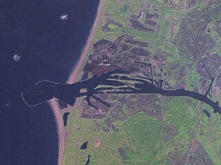
End of IJgeul at the IJmuiden jetties |
|
| location | Netherlands , North Holland |
| length | 43 kilometers |
| Built | 1982 |
| Expanded | until 2006 |
| Beginning | North Sea traffic separation area |
| The End | IJmuiden on the North Sea |
| Ports | Ijmuiden , Amsterdam , |
| Deep water ferry with a water depth of 21 meters | |
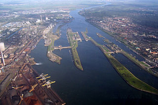
| End of IJgeul: North Sea Canal lock systems in IJmuiden | |
IJgeul or IJ-geul ( Dutch ) refers to a waterway for seagoing vessels off the coast of the Netherlands . The man-made fairway ( geul in Dutch ) is, so to speak , the extension of the North Sea Canal , which connects the port of Amsterdam with the North Sea in the province of North Holland . With a length of 43 kilometers, ships with a draft of up to 17.8 meters will be able to call at the port of IJmuiden .
Naming
The name IJ is the original name of a bay at the southern end of the former Zuidersee . This bay reached west from the old port of Amsterdam to the dunes of Velsen . For the construction of the North Sea Canal in the 18th century, the IJ was polded and a breakthrough to the North Sea was created at Velsen. There at the "mouth" (Dutch Muide ) of the North Sea Canal, the port city of IJmuiden was created with two approximately one kilometer long jetties , which opened up the coast over a kilometer at their base. With the mostly south-easterly winds and the south-north current along the coast, this makes it easier for the ships to stay on course in the port entrance. At the ends of the jetty, the entrance was initially 260 meters wide and seven meters deep. In Ijmuiden, there are two lighthouses with different heights in the extension of the entrance formed by the moles to help ensure safe access to the port . The two towers form a fire guide , the beacons of which must be one above the other when entering the lake.
Expansion of the fairway
The increase in ship sizes and shipping traffic in the canal made it necessary to enlarge and deepen the port entrance. Investigations and model tests at the University of Delft resulted in an optimized design of the protective moles with a semicircular, asymmetrical course, which can counteract silting up of the harbor entrance. The old pier head on the south side was set back so that the passage width is 450 meters. The extensions were added at both sea-side inflection points of the old piers, so that the north pier protrudes 800 meters and the south pier 1500 meters further into the North Sea. The width at the entrance to the IJgeul is 750 meters today. The work was carried out between 1960 and 1967 with the deepening of the entire access channel to 15 meters.
The coastline on the south side was adapted to the new course of the south mole by filling the gusset between the old and new mole with sand. This created a wide beach area with a beach resort and the beach lake Kennemermeer as IJmuiden aan Zee . In 2004 a breakthrough was made at the old pier to create the Marina Seaport IJmuiden as the fourth port basin in this area.
IJgeul
The fairway was further expanded until 1982, when the IJgeul was opened for ships with a maximum draft of 16.5 meters. The IJgeul is a straight extension of the fire guidelines of the two lighthouses of IJmuiden and extends 23 kilometers into the North Sea (measured from the end of the pier). The dredged width is 450 to 600 meters. Ships with a draft of over 14.10 meters have to sail in the IJgeul.
In order to also handle the fully loaded bulk carriers (e.g. For example, to transport ore to the steelworks in IJmuiden, to enable access to the port of IJmuiden, Rijkswaterstaat decided to deepen the fairway to 21 meters. The extension of the access channel associated with the deepening brought the IJgeul to a length of 43 kilometers and thus extends to the deep water routes and the traffic separation area of the North Sea. As a result, ships with a maximum draft of 17.8 meters have been able to call at the port since 2006. A turning point for large ships was created eleven kilometers from IJmuiden so that they can return to the port of call in an emergency. In order to maintain the IJ fairway at the necessary depth, ongoing dredging work is required, which amounts to around 10 million euros per year.
The ships with the maximum draft for the IJgeul can only call at the northern outer canal (Noorderbuitenkanaal) in IJmuiden in order to be unloaded at the deep-water berths there . Ships heading for the North Sea Canal may only have a draft of up to 13.70 meters.
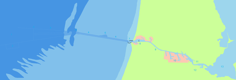
1st approach area; 2. Roadstead ; 3. End of IJgeul (43 km before the IJmuiden piers); 4. IJgeul; 5. End of the fire control line (23 km before IJmuiden); 6. insert; 7. Beginning of IJgeul (km 0);
8. IJmuiden port and locks; 9. North Sea Canal; 10. Amsterdam seaport; 11. Inland IJ; 12. Amsterdam; 13. Outer IJ (IJmeer);
See also
Web links
- The North Sea Rijkswaterstaat (Dutch)
- Map IJmuiden Site plan and port map IJmuiden (PDF)
Individual evidence
- ↑ History of Kennemerstrand, accessed on May 30, 2019 (Dutch).
- ↑ Key figures for the North Sea and the access channels accessed on March 4, 2019 ( Dutch ).
- ↑ Rijkswaterstaat 2014 award reports (PDF) accessed on March 4, 2019 (Dutch).
- ↑ Admission policy for IJgeul and the deep water berths accessed on March 4, 2019 (Dutch).
Coordinates: 52 ° 28 ' N , 4 ° 32' E


