Ilgenbach (Rems)
| Ilgenbach | ||
|
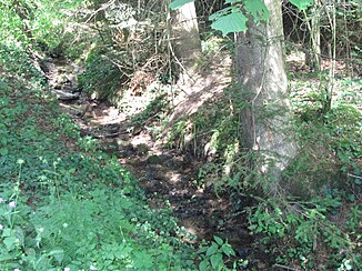
The Ilgenbach in the Ilgenklinge |
||
| Data | ||
| Water code | DE : 238365314 | |
| location |
Baden-Württemberg
|
|
| River system | Rhine | |
| Drain over | Rems → Neckar → Rhine → North Sea | |
| Source height | over 360 m above sea level NHN | |
| muzzle | in Lorch (Württemberg) at the summit bridge from the right and north into the Rems coordinates: 48 ° 47 ′ 49 ″ N , 9 ° 42 ′ 0 ″ E 48 ° 47 ′ 49 ″ N , 9 ° 42 ′ 0 ″ E |
|
| Mouth height | approx. 287 m above sea level NHN | |
| Height difference | approx. 73 m | |
| Bottom slope | approx. 70 ‰ | |
| length | 1 km | |
| Catchment area | approx. 60 ha | |
The Ilgenbach is a short tributary of the Rems , which flows into the Rems from the right and northeast in Lorch in the Ostalbkreis in Baden-Württemberg .
course
The Ilgenbach arises at about 360 m above sea level. NN in the Ilgenklinge , a quarter of a kilometer north of the tennis courts on the edge of the forest, where the water from a warrior fountain higher on the slope at almost 400 m above sea level. NN and several small source streams from small forest sound flowing together. The young stream flows southwest, passes the tennis courts on the left slope at the edge of the forest and then the sports area Echo above the right slope on a platform of the Schäfersfeld . The route of the Upper German-Raetian Limes cuts it in the area where it emerges from the forest . Here it is crossed today by the L 1154 from Lorch to Bruck and Pfahlbronn , which then climbs up the left ridge. Below the castle-like at over 340 m above sea level. NN on the left spur of the valley Lorch monastery , it gathers in the pond of a former small quarry. From there it continues to descend steadily to the former federal road 29 (today K 3313) through the Remstal, where it disappears in a short canal and, meanwhile, still crosses the Remstalbahn on a south course . It passes the Gasthof Gipfel , and flows into the Rems in the immediate vicinity of the summit bridge .
The Ilgenbach is only about 1.0 km long, but falls over 70 meters in altitude on its short running route. Its sources arise from the same layer as a tributary of the neighboring Götzenbach . The city of Lorch uses some of the water for its water supply.
See also
literature
- Topographical map 1: 25,000 Baden-Württemberg, as single sheet No. 7124 Schwäbisch Gmünd North and No. 7224 Schwäbisch Gmünd South
Individual evidence
- ↑ a b Height according to the contour line image on the background layer Topographic map of the online map server of the State Institute for the Environment, Measurements and Nature Conservation Baden-Württemberg (LUBW). See the → web links .
- ↑ Length according to the water network layer ( AWGN ) of the LUBW's online map server.
- ↑ Catchment area measured on the background layer topographic map of the LUBW's online map server.
