
Illhorn
| Illhorn | ||
|---|---|---|
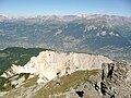
 View from Illsee to the Illhorn |
||
| height | 2716 m above sea level M. | |
| location | Canton of Valais , Switzerland | |
| Mountains | Valais Alps | |
| Dominance | 1.98 km → Schwarzhorn | |
| Notch height | 234 m ↓ Illpass | |
| Coordinates | 613694 / 123 512 | |
|
||


The Illhorn is a mountain above the resort of Chandolin in the canton of Valais , Switzerland . The summit with a height of 2716 m above sea level. M. is the northernmost mountain in the mountain range from Les Diablons via Bella Tola to Illhorn, which separates the Val d'Anniviers from the Turtmann valley and also forms the language border. The small Illstausee is located in the south of the Illhorn . The Illhorn is only about 7 kilometers away from the town of Sierre , which is almost 2200 meters below .
The Illhorn offers an excellent view from Mont Blanc in the west over the Bietschhorn , the Bernese Alps to the Valais four-thousand-meter peaks with the Weisshorn , the Zinalrothorn , the Dent Blanche and the Matterhorn .
The ascent from Chandolin takes about 2 hours via the Alpage de Chandolin and the Pas de l'Illsee , by the chairlift to the Tsapé mountain station at 2580 m above sea level. M. it can be abbreviated. In winter, a ski lift takes skiers to just below the summit.
From the summit, the terrain plunges steeply into the Illgraben, which is over 1,500 meters lower, and the Pfynwald in the Rhone Valley. The Illgraben is one of the most geologically unstable valleys in Switzerland. The strong erosion makes vegetation impossible.
photos

Summit of the Illhorn.

Illhorn above Chandolin.

The Pfynwald with the snow-covered Illhorn.
View from the Illhorn to the Illgraben.


