
Invalidenstrasse (Vienna)
| Invalidenstrasse | |
|---|---|
|
|
|
 |
|
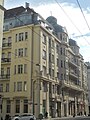
| The last part of Invalidenstrasse with the Elisabethinen-Haus (right) | |
| Basic data | |
| place | Vienna |
| District | Country road |
| Created | 1909 |
| Connecting roads | Am Heumarkt , Hintere Zollamtsstrasse |
| Cross streets | Ungargasse , Landstraßer Hauptstrasse |
| use | |
| User groups | Pedestrian traffic , bicycle traffic , car traffic , tram |
| Road design | Multi-lane |
The Invalidenstrasse located on the 3rd Vienna district highway . The street was named in 1883 after the former invalids ' house that was located here.
history
Cardinal Sigismund von Kollonitz , Archbishop of Vienna , acquired - with financial support from Emperor Karl VI. and other benefactors - in 1727 a palace in the suburb of Landstrasse to build a poor and supply house. Joseph II rededicated the building as a military house for invalids . Around 1830 the building had orientation number 1. The Imperial and Royal Invalidenhaus was moved to Lainz in 1909 , the old building was demolished and the property was parceled out. Today there are Untere Viaduktgasse, Ditscheinergasse and Grailichgasse (called Invalidenstrasse district ). It is a closed ensemble that was created within a short time (1910/11), which also includes some houses in Untere Viaduktgasse.
Location and characteristics
The street runs as an extension of the Hinteren Zollamtsstraße from the Marxergasse along the former market hall, then crosses the Landstraßer Hauptstraße and divides at the Stadtpark into the Ungargasse and right over the Große Ungarbrücke towards the Stadtpark into the Heumarkt . Coming from Hintere Zollamtsstraße, the Wien Mitte train station is on the right and residential buildings with shops on the left. When you cross the country road, you will first find the shopping and entertainment center W3 on the right-hand side and then the headquarters of Raiffeisen Bank International . On the left side there are residential buildings with business premises.
building
Important buildings, city-inward side
- Wien Mitte train station
- Business and cinema center W3
- Raiffeisen Bank International (Entrance Am Stadtpark )
Important buildings, side out of town
On the outskirts of the city, the building was built with representative facades facing the city center - the train station and its ancillary buildings were not an obstacle to view at that time
- No. 1: The building was built by Adolf Oberländer around 1910 .
- No. 3: Built in 1910 by Emil Reitmann, seat of the Kyrgyz embassy
- No. 5-7: The house was built in 1911 by Arthur Baron . It is a mighty semi-detached house designed for long-distance effects with domed bay windows connected to balconies and a high gable with a studio floor. There is a surrounding stone balcony above the base storeys. The marble-clad reception room of the management rooms of the Poldihütte steelworks designed by Josef Hoffmann has been preserved.
- No. 9 (= Ditscheinergasse 2–4): The house was built in 1910 by Jakob Gartner . It has neo-baroque-secessionist facade decor and wrought iron portals.
- Elisabethinen's residential and commercial building (No. 13–19 unger.), Built by Karl Koblischek 1932–1936 ( listed )
traffic
The road is a main road A reported. It take tram O and night bus N75. The tram lines E2, G2 and H2 ran here.
Picture gallery

The house Invalidengasse 1 (= Marxergasse 6)
No. 5-7

No. 9 (Ditscheinergasse 2–4)

Elisabethinen's residential and commercial building
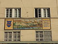
Mosaic depicting the old building on the Elisabethinen House (No. 13-19)
,_Vienna,_2018_(I).jpg)


literature
- Felix Czeike : Historical Lexicon Vienna . Kremayr & Scheriau: Vienna 1994
- Walther Brauneis , Géza Hajós : Die Kunstdenkmäler Wien , Volume 2, Österreichische Kunsttopographie , Verlag Schroll, 1980, ISBN 978-370310470-1 , Chapter III. Invalidenstrasse district: Ditscheinergasse, Invalidenstrasse, Untere Vaduktgasse , p. 55 ff
Individual evidence
- ↑ Embassy of the Kyrgyz Republic ( page no longer available , search in web archives ) Info: The link was automatically marked as defective. Please check the link according to the instructions and then remove this notice. , bmeia.gv.at
- ^ Dehio Vienna II-IX & XX, Verlag Anton Schroll & Co., Vienna, 1993, p. 111
- ^ Dehio Vienna II-IX & XX, Verlag Anton Schroll & Co., Vienna, 1993, p. 106
Coordinates: 48 ° 12 '19.4 " N , 16 ° 23' 6.6" E