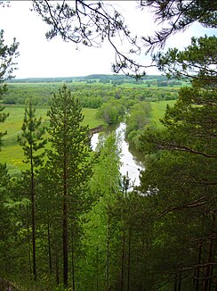
Irish (Sylwa)
|
Irish Ире́нь |
||
| Data | ||
| Water code | RU : 10010100812111100013170 | |
| location | Perm Region ( Russia ) | |
| River system | Volga | |
| Drain over | Sylwa → Chusovaya → Kama → Volga → Caspian Sea | |
| source | in Oktyabrsky district 56 ° 41 ′ 20 ″ N , 57 ° 13 ′ 16 ″ E |
|
| muzzle |
Sylwa coordinates: 57 ° 27 '7 " N , 56 ° 55' 41" E 57 ° 27 '7 " N , 56 ° 55' 41" E
|
|
| length | 214 km | |
| Catchment area | 6110 km² | |
| Drain |
MQ |
35.5 m³ / s |
| Medium-sized cities | Kungur | |
| Communities | Urasmetievo , Chaika | |
The Irish ( Russian Ире́нь ) is a left tributary of the Sylwa in the Russian region of Perm .
The Irish rises in Oktyabrsky district in the southeast of the Perm region. It flows mainly in a northerly direction and flows into the Sylwa, a tributary of the Chusovaya , in the city of Kungur . The Irish has a length of 214 km. It drains an area of 6110 km². The mean discharge is 35.5 m³ / s. There are karst phenomena in the catchment area of the Irish . The river is mainly fed by the snowmelt . It is covered with ice between November and April.
