
Jakobsberg (Beverungen)
|
Jakobsberg
City of Beverungen
Coordinates: 51 ° 37 ′ 56 ″ N , 9 ° 19 ′ 46 ″ E
|
|
|---|---|
| Height : | 325 (390–343) m above sea level NHN |
| Area : | 3.03 km² |
| Residents : | 300 |
| Population density : | 99 inhabitants / km² |
| Incorporation : | January 1, 1970 |
| Postal code : | 37688 |
| Area code : | 05273 |
 Location of Jakobsberg in Beverungen
|
|
Jakobsberg is a district of Beverungen in the Höxter district , North Rhine-Westphalia .
Geographical location
Jakobsberg is located in the Oberwälder Land about 5 km southwest of the city center of Beverungen and about 1.5 km east (as the crow flies ) above the confluence of the Jakobsberg brook near Dalhausen (in the deep valley ) with the Bever . On the western slopes of the Schlee Bergs (also Schlehberg called; 350.1 m above sea level. NHN ), a forestless North spurs of adjacent south at Haarbrück located Höltkenkamm ( 365.1 m ), it spreads and 290 interlocutory 343 m of height; A wind farm is located on these elevations .
history
Jakobsberg takes its name from the Catholic parish church of St. James the Elder , which was built in 1150. In 1485 a brotherhood of James was founded. The village was part of the Corvey Monastery for a long time until it fell to the Paderborn Monastery in 1779, which had already enclosed the village.
On January 1, 1970 Jakobsberg was incorporated into the city of Beverungen.
traffic
District road 44, which climbs steeply west of the village , runs through Jakobsberg - from federal road 241, which runs past the Jakobsberg estuary near Dahlhausen, to state road 838, which runs between this road at Beverungen in the north and Haarbrück in the south - in a west-east direction .
Buildings
_-_Jakobuskapelle_(003).JPG)
- Jakobusplatz (on the right-hand side of Jakobusstraße just before the exit towards Dalhausen) with the Jakobsberger Quelle and the Jakobus Chapel. The chapel was built in 1957 to replace the old chapel.
- historic parish church of St. James
- Way of the Cross on the Kiepenberg (shortly after leaving the town towards Dalhausen) with a panoramic view
gallery
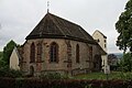
Parish Church of St. James, old part of the building

Parish Church of St. James, entrance

Parish church St. Jakobus, entrance area with cross, bells and portal stones from the 15th century
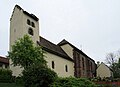
Bell tower and new extension with its own small. chapel

St. James Chapel

Cemetery right next to St. Jakobus, view towards Haarbrück

Cemetery right next to St. Jakobus, view towards Dalhausen
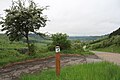
Marking on the high-altitude hiking trail "Kalkmagerrasen adventure area" near Jakobsberg

_1.jpg)
_2.jpg)
.jpg)
_-_Jakobuskapelle_(002).JPG)
_1.jpg)
_1.jpg)
.jpg)
Web links
Individual evidence
- ↑ Topographical Information Management, Cologne District Government, Department GEObasis NRW ( Notes )
- ↑ Jakobsberg on beverungen.de
- ↑ Martin Bünermann: The communities of the first reorganization program in North Rhine-Westphalia . Deutscher Gemeindeverlag, Cologne 1970, p. 107 .
- ↑ Jakobsberg - idyllic gem on Bergeshöh , on beverungen.de (PDF; 332.6 kB)
- ↑ Catholic Church of St. Jakobus the Elder in Jakobsberg - history of the parish and pilgrimage on www.heiligstedreifaltigkeit-beverungen.de
- ↑ Flyer Way of the Cross ; published by the Tourist Information of the city of Beverungen