Jakobselva (Sør-Varanger)
|
Jakobselva Ворьема, Worjema, Vuorján, Vuoremijoki |
||
|
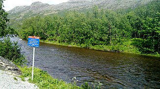
Jakobselva with a warning sign that indicates the border |
||
| Data | ||
| Water code | NO : 247.Z, RU : 02010000112101000000252 | |
| location |
Sør-Varanger municipality in Troms og Finnmark county ( Norway ), Murmansk Oblast ( Russia ) |
|
| River system | Jakobselva | |
| source | in Rajon Pechenga ( Russia ) | |
| muzzle |
Varangerfjord ( Barents Sea ) Coordinates: 69 ° 47 ′ 20 " N , 30 ° 49 ′ 9" E 69 ° 47 ′ 20 " N , 30 ° 49 ′ 9" E |
|
| Mouth height |
0 m
|
|
| length | 45 km | |
| Catchment area | 236.44 km² | |
| Drain |
MQ |
4.13 m³ / s |
| Left tributaries | Holmvasselva, Sandvasselva, Korpvasselva | |
| Right tributaries | Siuvjakuru | |
| Communities | Grense Jakobselv | |
|
Border marking on the Norwegian bank of the Jakobselva |
||
The Jakobselva ( Russian Ворьема ; Russian transcription : Worjema; Nordsam. Vuorján; Finnish Vuoremijoki ) is a 45 km long river in the far north of Scandinavia.
The river has its source in the Russian Rajon Pechenga flows north, then runs between the municipality Sør-Varanger in the Fylke Troms og Finnmark and Murmansk Oblast . It forms the state border between Norway and Russia . Finally, the Jakobselva flows into a small estuary near the Norwegian settlement Grense Jakobselv and flows over the Varangerfjord into the Barents Sea .
The catchment area covers 236.44 km², the mean discharge at the mouth 4.13 m³ / s. Between 1920 and 1944, the river formed the border between Norway and Finland. The river is considered an excellent salmon river . However, along the section of the river that now forms the border between Norway and Russia, fishing is only permitted under very specific circumstances and only for a specific group of people.
Web links
Individual evidence
- ↑ Jakobselva (Sør-Varanger) in the State Water Register of the Russian Federation (Russian)

