Sør-Varanger
| coat of arms | map | |
|---|---|---|

|
|
|
| Basic data | ||
| Commune number : | 5444 | |
| Province (county) : | Troms and Finnmark | |
| Administrative headquarters: | Kirkenes | |
| Coordinates : | 69 ° 30 ′ N , 29 ° 4 ′ E | |
| Surface: | 3,971.42 km² | |
| Residents: | 10,158 (Feb 27, 2020) | |
| Population density : | 3 inhabitants per km² | |
| Language form : | Bokmål | |
| Website: | ||
| politics | ||
| Mayor : | Rune Rafaelsen ( Ap ) (2019) | |
| Located in the province of Troms and Finnmark | ||

|
||
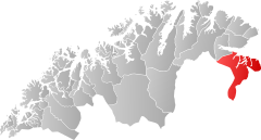
Sør-Varanger or Syd- Varanger (German: Süd-Varanger) is a Norwegian municipality bordering Russia and Finland in the Fylke Troms og Finnmark , formerly Finnmark .
The neighboring municipalities are Nesseby in the west, Petschenga (Russia) in the east and Inari ( Finland ) in the southwest. 10,158 people (as of February 27, 2020) live in Sør-Varanger in an area of around 3,968 km². The administrative seat and largest town is the city of Kirkenes .
The parish parts
The municipality of Sør-Varanger consists of the towns of Kirkenes , Bjørnevatn , Storskog , Grense Jakobselv , Pasviktal , Bugøynes and Neiden .
Kirkenes
Kirkenes is the largest town in the municipality of Sør-Varanger with around 4900 inhabitants. In the town of Kirkenes is the Sør-Varanger Museum - Borderland Museum as the main museum of the municipality. There is also the Andergrotte, an air raid shelter as a museum and the Savio Museum, the museum of the Sami artist Savio.
Bjørnevatn
Bjørnevatn was created together with the AS Sydvaranger mining company and is also known as the “mining town”. The place has 1500 inhabitants. The place is characterized by long spoil heaps. Here is a tunnel in which around 2,500 people found shelter at the end of the Second World War. The mine facilities were closed in 1996 and reopened in 2009. Bjørnevatan is connected to the port of Kirkenes by the Kirkenes – Bjørnevatn railway to transport iron ore .
Storskog
Here in Storskog is the only official border crossing between Russia and Norway.
Grense Jakobselv
The place Grense Jakobselv is about 60 km east of Kirkenes . The place is located on the Jakobselv river of the same name . Salmon can be fished here; however, only 30 Norwegians receive a fishing license a year. In 1869 the King Oscar II Chapel was built to mark the border with Russia. You can also see the priest's house from 1867 and the remains of old houses. Nobody lives in the place at the moment.
Pasvik
The Pasvik valley extends from Kirkenes for about 100 km in a southerly direction. The Pasvikelva River flowing through the valley forms the border with Russia. It is the second longest river in Norway and an outflow of Lake Inari in Finland and flows into the Barents Sea at Elvenes . The area is well developed for tourism; Several parts of the Sør Varanger Museum are located in the main town of the valley, Svanvik . The Øvre-Pasvik National Park , an extension of the Siberian taiga, is also located in the Pasvik Valley . The Treriksrøysa triangle is located in the national park .
Bugøynes
The place Bugøynes is located about 100 km north-west of Kirkenes. 300 inhabitants, mostly of Finnish descent, live in the former fishing village. The place did not burn down during World War II, so the Finnish design of the houses from the 19th century has been preserved. In Bugøynes, too, you can see parts of the Sør-Varanger Museum, such as a restored quay and a merchant's house from 1850. The king crab is caught in the local waters .
Envy
Neiden is on the European route 6 west of Kirkenes . The distance to the Finnish border is ten kilometers. The place is a center of the Scoltsamian culture. The Neidenelv river with the Skoltefossen waterfall is rich in salmon . The Russian Orthodox St. George's Chapel, which is said to have been built in 1565, is worth seeing.
coat of arms
Description : In gold and red with large, right-angled flames.


