
Båtsfjord
| coat of arms | map | ||
|---|---|---|---|

|
|
||
| Basic data | |||
| Commune number : | 5443 | ||
| Province (county) : | Troms and Finnmark | ||
| Administrative headquarters: | Båtsfjord | ||
| Coordinates : | 70 ° 29 ′ N , 29 ° 56 ′ E | ||
| Surface: | 1,434.78 km² | ||
| Residents: | 2,221 (Feb 27, 2020) | ||
| Population density : | 2 inhabitants per km² | ||
| Language form : | neutral | ||
| Website: | |||
| politics | |||
| Mayor : | Ronald Wærnes ( Sp ) (2019) | ||
| Located in the province of Troms and Finnmark | |||

|
|||

Båtsfjord ( Sami : Báhcavuona ) is a municipality in the Norwegian Fylke Troms og Finnmark . The municipality has 2221 inhabitants (as of February 27, 2020). The administrative seat is the place of the same name Båtsfjord.
geography
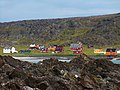
Båtsfjord is located in eastern Finnmark on the Barents Sea . The municipality borders on the neighboring municipalities of Vardø , Vadsø , Berlevåg and Tana . The two fjords Båtsfjord and Syltefjord intersect in the area of the municipality . The town of the same name, which is the administrative center, is located on the Båtsfjord. The village is the only Tettsted in the municipality and almost the entire population of the municipality lives there.
In the interior of the commune there are larger uninhabited areas that slope steeply towards the sea. Several rivers flow from the area into the Barents Sea. The highest elevation is the Skipskjølen (Sami: Bealjáidčearru) with a height of 633.8 moh. which is located on the border with Vadsø in the south.
The inhabitants of the municipality are called Båtsfjording . Like many other municipalities in the province of Troms og Finnmark, Båtsfjord has neither Nynorsk nor Bokmål as an official language, but is neutral on this issue.
history
Until December 31, 2019, Båtsfjord was part of what was then the province of Finnmark . As part of the regional reform in Norway, this was transferred to the newly created province of Troms og Finnmark on January 1, 2020. During the Second World War , the community's settlements were only slightly damaged. This is why Båtsfjord was set up as a supply base in 1944.
The municipality's boundaries were last changed in 1964. At that time, a part in the southeast of the former municipality was transferred to Vardø . While almost the entire population lives in the village of Båtsfjord today, there were three fishing villages Hamningberg , Makkaur and Syltefjord in the middle of the last century . 700 people lived in the former in 1940. All three villages are now uninhabited.
The port of Båtsfjord is protected in the fjord. Båtsfjord is the landing stage for Hurtigruten . The connecting road to Europastraße 6 is open all year round. The båtsfjord airport is located just south of the village Båtsfjord.
economy
The main source of income for the community is fishing and the related processing. Reindeer are kept in the uninhabited area inside in summer.
Coat of arms and name
The coat of arms, which has served as the municipality's official coat of arms since 1985, shows a silver fish hook on a blue background. It should symbolize the fishing in Båtsfjord. The name Båtsfjord consists of the two parts “Båt” and “-fjord”, the former standing for “botn”, meaning the inner end of a fjord.
Attractions
- The church from 1971 with a 85 m² glass painting
- TV mast (241.8 m, the highest in Norway)
- Skarvskiten, a bird mountain 1 km from Båtsfjord
Personalities
- Frank Bakke-Jensen (* 1965), politician
photos

Båtsfjord
Hamningberg in Båtsfjord

Båtsfjord
.jpg)


Web links
- Båtsfjord in the store norske leksikon (Norwegian)
- Facts about Båtsfjord from Statistisk sentralbyrå (Norwegian)
Individual evidence
- ↑ Statistisk sentralbyrå - Befolkning
- ↑ a b Båtsfjord municipality. In: Norgeskart. Kartverket, accessed August 13, 2020 (Norwegian).
- ↑ Tettsteders following og areal. Statistisk sentralbyrå , December 4, 2019, accessed August 13, 2020 (Norwegian).
- ↑ a b c Svein Askheim: Båtsfjord . In: Store norske leksikon . March 15, 2020 (Norwegian, snl.no [accessed August 13, 2020]).
- ↑ Høyeste fjelltopp i hver commune. September 1, 2015, accessed on August 13, 2020 (Norwegian Bokmål).
- ↑ Innbyggjarnamn. Språkrådet, accessed August 13, 2020 (Norwegian Nynorsk).
- ↑ Forskrift om målvedtak i Kommunar og fylkeskommunar (målvedtaksforskrifta). In: Lovdata. January 6, 2020, accessed August 13, 2020 (Norwegian).
- ↑ Kommunal- og moderniseringsdepartementet: Nye kommune- og fylkesnummer fra 2020. In: regjeringen.no. October 27, 2017, accessed August 13, 2020 (Norwegian).
- ↑ Svein Askheim: Hamningberg . In: Store norske leksikon . June 8, 2020 (Norwegian, snl.no [accessed August 13, 2020]).
- ^ Båtsfjord Airport. Avinor, accessed August 13, 2020 .
- ↑ Båtsfjord. In: Norsk stadnamnleksikon. Retrieved August 13, 2020 (Norwegian).