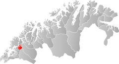
Sørreisa
| coat of arms | map | |
|---|---|---|

|
|
|
| Basic data | ||
| Commune number : | 5419 | |
| Province (county) : | Troms and Finnmark | |
| Administrative headquarters: | Sørreisa | |
| Coordinates : | 69 ° 5 ' N , 18 ° 11' E | |
| Surface: | 362.95 km² | |
| Residents: | 3,464 (Feb 27, 2020) | |
| Population density : | 10 inhabitants per km² | |
| Language form : | neutral | |
| Website: | ||
| politics | ||
| Mayor : | Jan-Eirik Nordahl ( Ap ) (2015) | |
| Located in the province of Troms and Finnmark | ||

|
||
Sørreisa ( Sami Ráisavuona ) is a municipality in the north Norwegian province ( Fylke ) Troms og Finnmark . The municipality has 3464 inhabitants (as of February 27, 2020). The administrative seat is the place of the same name Sørreisa.
geography
Sørreisa is located on the south-east bank of the Reisafjorden, a south-east continuation of the Solbergfjord . Lake Reisvatnet (Sami: Ráissajávri ) and most of the Andsvatnet belong to the municipality .
On the coast and in the north the area is flat, especially in the south-east there are larger elevations and several valleys. The highest elevation is the Hjerttinden (Sami: Basečohkka ) with 1381 moh. The population is mainly concentrated in the area around the Reisafjord. The place Sørreisa is the only Tettsted in the municipality. 1566 inhabitants live there (as of 2019). The two provincial roads 84 and 86 also meet in the village, both of which connect to European route 6 (E6).
Like many other municipalities in the province of Troms og Finnmark, Sørreisa has neither Nynorsk nor Bokmål as an official language, but is neutral on this issue. The inhabitants of the municipality are called Sørreisværing .
history
Sørreisa Municipality was founded in 1886 when it was split off from Tranøy . In 1964, the southeastern part of the island of Senja , which had 129 inhabitants at the time, was handed over from Sørreisa to Lenvik .
economy
The village's agriculture is mainly based on cattle and sheep farming . The wood products industry is of great importance for industrial production, as, among other things, a chipboard and a prefabricated house factory are located in the community. Another important employer is the Norwegian military , as there is a branch of the Norwegian Air Force in the area.
In 2019 only 828 of the 1723 inhabitants of the municipality worked in Sørreisa itself. 527 people were employed in the neighboring municipality of Lenvik and 142 others in Målselv .
Surname
The name "Sørreisa" is derived from the name of the Reisaelva river. This in turn probably comes from "rísa", meaning "to rise". Further north is the municipality of Nordreisa , which also got its name from this river.
Personalities
- Herborg Finnset (* 1961), Lutheran clergyman and theologian
Web links
- Sørreisa in the store norske leksikon (Norwegian)
Individual evidence
- ↑ Statistisk sentralbyrå - Befolkning
- ^ Sørreisa commune. In: norgeskart.no. Kartverket, accessed July 21, 2020 (Norwegian).
- ↑ Høyeste fjelltopp i hver commune. September 1, 2015, accessed on July 21, 2020 (Bokmål in Norwegian).
- ↑ Tettsteders following og areal. In: ssb.no. Statistisk sentralbyrå, November 4, 2019, accessed July 21, 2020 (Norwegian).
- ↑ Forskrift om målvedtak i Kommunar og fylkeskommunar (målvedtaksforskrifta). In: Lovdata. January 6, 2020, accessed July 21, 2020 (Norwegian).
- ↑ Høyeste fjelltopp i hver commune. In: Kartverket. September 1, 2015, accessed on July 21, 2020 (Bokmål in Norwegian).
- ↑ a b Geir Thorsnæs: Sørreisa . In: Store norske leksikon . March 5, 2018 (Norwegian, snl.no [accessed July 21, 2020]).
- ↑ Pendlingsstrømmer. In: Statistics Norway. Retrieved July 21, 2020 (Norwegian).
- ↑ Sørreisa. In: Norsk stadnamnleksikon. Retrieved July 21, 2020 (Norwegian).
- ↑ Nordreisa. In: Norsk stadnamnleksikon. Retrieved July 21, 2020 (Norwegian).
