
Kåfjord (municipality)
| coat of arms | map | ||
|---|---|---|---|

|
|
||
| Basic data | |||
| Commune number : | 5426 | ||
| Province (county) : | Troms and Finnmark | ||
| Administrative headquarters: | Olderdalen | ||
| Coordinates : | 69 ° 27 ' N , 20 ° 45' E | ||
| Surface: | 991.24 km² | ||
| Residents: | 2,071 (Feb 27, 2020) | ||
| Population density : | 2 inhabitants per km² | ||
| Language form : | Bokmål , North Sami and Kven | ||
| Website: | |||
| politics | |||
| Mayor : | Bernt Eirik Lyngstad ( Ap ) (2019) | ||
| Located in the province of Troms and Finnmark | |||

|
|||

Kåfjord ( North Sami Gáivuotna ; Kven Kaivuono ) is a municipality in northern Norway in the province ( Fylke ) Troms og Finnmark . The administrative seat of the municipality is Olderdalen.
The inhabitants of Kåfjord are predominantly Sami , but most of them speak Norwegian as their mother tongue due to the long state pressure to assimilate .
The international ethno festival Riddu Riđđu is held annually in Manndalen (Sami Olmmáivággi ) .
geography
The municipality of Kåfjord is located on the east side of the Lyngenfjord and is named after one of its tributaries, the Kåfjord , which cuts 25 kilometers south-east into the inland . The municipality extends in the south to the Finnish border. Here, just on the Finnish side, lies the Haltitunturi , the highest point in Finland , at 1,324 meters above sea level . The highest mountain in the municipality is the 1375 meter high Isfjellet , whose massif rises almost vertically from the southern end of the Kåfjord. The Ráisduottarháldi (1361 m), the Nordmannviktinden (1355 m) and the Čiččenvárri (1316 m) are also among the highest peaks .
The length of the coast in the area of the municipality of Kåfjord is approx. 70 kilometers. These are steep rocky coasts, interrupted by trough valleys , some of which are wide , of which Kåfjorddalen, Manndalen, Olderdalen and Nordmannvikdalen are the most important. The most important rivers also flow through these valleys, of which the Kåfjordelva ( called Guolášjohka and Smuolkojohka in the upper reaches ) is the longest at 40 kilometers. It flows through the Guolasjávri , with approx. 10 km² the largest of the numerous fell lakes in the municipality.
Settlements
In addition to the administrative headquarters in Olderdalen, the municipality consists of other settlements:
|
|
Sabitjåkka and some "hytter" on and around the Guolasjávri are not permanently inhabited, but only during the short period of summer. This also applies to large parts of the settlements in Manndalen or Kåfjorddalen that are not directly by the sea.

Olderdalen, the Kåfjord community center
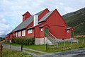
Kåfjord Church
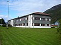
Kåfjord City Hall


The valley of the Kåfjord

Church in the settlement of Birtavarre at the end of the Kåfjord
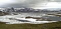
The Guolasjávri near the Finnish border


