Kvænangen (municipality)
| coat of arms | map | |
|---|---|---|

|
|
|
| Basic data | ||
| Commune number : | 5429 | |
| Province (county) : | Troms and Finnmark | |
| Administrative headquarters: | Burfjord | |
| Coordinates : | 69 ° 53 ' N , 21 ° 58' E | |
| Surface: | 2,109.37 km² | |
| Residents: | 1,191 (Feb 27, 2020) | |
| Population density : | 1 inhabitant per km² | |
| Language form : | neutral | |
| Website: | ||
| politics | ||
| Mayor : | Eirik Losnegaard Mevik ( Ap ) (2019) | |
| Located in the province of Troms and Finnmark | ||

|
||
Kvænangen ( Sami Návuona ) is a municipality in Northern Norway .
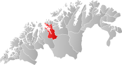
It is located in the north of the province ( Fylke ) Troms og Finnmark and includes the area around the eponymous fjord Kvænangen and the coastal hinterland. Burfjord is the administrative center.
The majority of the population belongs to the Sami people , the Kvener (descendants of Finnish immigrants of the 18th century) and Norwegians are in the minority; however, all three ethnic groups speak mostly Norwegian today.
history
The island of Skorpa in the Kvænangen Fjord belongs to Kvænangen. In May and June 1940, after the German invasion of Norway , a Norwegian prisoner of war camp for around 450 captured German soldiers and interned crews of German merchant and fishing ships was set up.
During the German occupation of Norway, there was a Wehrmacht labor camp in Kvænangen . The prisoners were supported by the population with food and therefore had comparatively good prison conditions. When the Germans withdrew, the camp was forcibly evacuated and burned down.
Individual evidence
Web links
